
A photograph captioned by BeckerFraserPhotos, "This house at 23 Seabreeze Close, Bexley, was badly affected by liquefaction in the previous earthquakes. The impact of the 23 December 2011 earthquakes and further liquefaction was to break the house through the middle".

A photograph of liquefaction along the footpath in front of St Paul's Church on Gayhurst Road. The church was severely damaged during the 4 September earthquake. Tape has been placed around the building to warn people off.

A photograph of cracks running through the driveway of a residential property on Glenarm Terrace in Dallington. The cracks have been filled in with stones and planks of wood have been placed over them to allow the residents to continue using the driveway.

A photograph of volunteers from the Wellington Emergency Management Office standing outside St Paul's School on Gayhurst Road. There are cracks in the asphalt in front, and liquefaction on the ground.

A photograph of large cracks in the pavement in front of St Paul's School in Dallington. Liquefaction silt can also be seen. Police tape has been draped across the entrance of the building to the left.

A photograph of a CERA billboard in a paddock in Dallington, near the Gayhurst Road bridge. The billboard heading reads, "Crown-owned land clearance in the residential red zone". Graffiti has been spray-painted over the rest of the sign.

A photograph of a scarecrow on Kingford Street in Horseshoe Lake. A sign next to the figure reads, "You like my wig. I love you Santa. Ho ho ho, is Santa coming to Kingsford? Please sit on my lap".

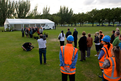
Students from the University of Canterbury observing a two minute silence during their lunch break to remember those who died in the 22 February 2011 earthquake. The students have volunteered to dig up liquefaction as part of the Student Volunteer Army.

An aerial photograph of Burwood. The photograph has been captioned by BeckerFraserPhotos, "This area of houses circumscribed by a green belt in a horseshoe shape is called Horseshoe Lake, and is all residential red zoned".

Photograph captioned by BeckerFraserPhotos, "Extensive cracking to the Wainoni Road bridge. There has been a vehicle weight limit of 3500kg placed on the bridge. A person was placed on duty at all times to police this".

An aerial photograph of a residential area in New Brighton. The photograph has been captioned by BeckerFraserPhotos, "New Brighton Ave, Waygreen Ave, Wattle Drive and Atlantis Street, all red zoned".

Members of the Student Volunteer Army walking down Fleete Street in Dallington. Many of the students are holding shovels which they will use to dig liquefaction out of residents' properties. In the background, students can be seen digging as well as piles of liquefaction already placed on the road.

A road cone on the side of Kingsford Street in the Horseshoe Lake district. The cone has been decorated to look like Santa Claus. The photograph has been captioned by BeckerFraserPhotos, "This cone looks jaunty with a particularly flirtatious swing to its skirt, which provides a nice contrast to the sand-bagged road sign".

A powhiri performed by Ngai Tahu elders to welcome workers of the Stronger Christchurch Infrastructure Rebuild Team (SCIRT). Phil Goff is standing in the centre of the group that is being welcomed. The ceremony was held in Burwood Park.

Leader of the Student Volunteer Army, Sam Johnston, speaking to students from on top of the ENSOC fire engine in Burwood Park. The students have been enjoying a barbeque lunch break after volunteering to dig up liquefaction as part of the Student Volunteer Army.

Photograph captioned by BeckerFraserPhotos, "The Avon River is at this point on Avonside Drive 10 km from the estuary. At high tide the river now overflows its banks showing that the ground has sunk by about 40 cm".

An aerial photograph captioned by BeckerFraserPhotos, "The River Avon winding its way through densely populated housing. For now, much of the land alongside the River Avon is zoned red, and will not be built upon any time soon".

A photograph of a cardboard sign outside St Paul's Church in Dallington. The sign reads, "St Paul's Parish Mass, Sunday 10am, Marian College Hall, North Parade". In the background police tape is draped around the building.

An aerial photograph of St Paul's School in Dallington. The photograph has been captioned by BeckerFraserPhotos, "St Pauls School, 17 Gayhurst Road, suffered badly from liquefaction in the September earthquake. This area is all red zoned".

Reverend Peter Beck leading a prayer at the Stronger Christchurch Infrastructure Rebuild Team (SCIRT) opening. Mayor Bob Parker is standing to the right of Reverend Peter Beck. The ceremony was held in Burwood Park.

A photograph of the Wellington Emergency Management Office, taking photos of St Paul's Church in Dallington. The church was severely damaged after the 4 September earthquake. Police emergency tape can be seen around the building, keeping people away.

A powhiri performed by Ngai Tahu elders to welcome workers of the Stronger Christchurch Infrastructure Rebuild Team (SCIRT). Reverend Peter Beck and Earthquake Minister Gerry Brownlee can be seen standing amongst the group. The ceremony was held in Burwood Park.
A powhiri performed by Ngai Tahu elders to welcome workers of the Stronger Christchurch Infrastructure Rebuild Team (SCIRT). Phil Goff is standing in the centre of the group that is being welcomed. Two cameras are filming the welcome. The ceremony was held in Burwood Park.

A photograph of the earthquake damage to the entrance of a driveway on Glenarm Terrace. A large hole in the foreground has had a road cone placed inside it. Other large cracks and liquefaction can bee seen. A man in overalls has parked his van next to the damage.

A house on Avonside Drive showing damage from the 4 September 2010 earthquake. Numerous cracks in the masonry can be seen, and several sections of brick have fallen off the walls. The building's porch has also collapsed. A pile of dried liquefaction is visible in the driveway.

An aerial photograph of a residential area in Avonside. The photograph has been captioned by BeckerFraserPhotos, "Sullivan Park, Avonside. All of this is residential red zoned except for a tiny piece in the top right hand corner".

A photograph of the earthquake damage to St Paul's School in Dallington. Large cracks can be seen in the surface of the asphalt. Silt from liquefaction is visible in front of the school buildings. Tape has been placed on the building to keep people away.

An aerial photograph of the Horseshoe Lake residential area. The photograph has been captioned by BeckerFraserPhotos, "The prominent street is Kingsford Street (bottom left to top centre), with Moncrieff Street off it at the top right and Tasman Place at the bottom. Horseshoe Lake".

An aerial photograph of a residential area in New Brighton. The photograph has been captioned by BeckerFraserPhotos, "New Brighton Road, Wattle Drive and Waygreen Avenue. These houses are mostly red zoned with a few green zoned houses in the bottom right".

An aerial photograph of Fitzgerald Avenue. The photograph has been captioned by BeckerFraserPhotos, "Oxford Terrace on the left side of the River Avon and Fitzgerald Avenue on the right. The street running across the foreground of the photograph is Kilmore Street".