
Photograph captioned by BeckerFraserPhotos, "23 Seabreeze Close, Bexley. The view through the window here shows the size of the silt piled against the front door".

Photograph captioned by BeckerFraserPhotos, "Looking south along Kerrs Road which is zoned red in the foreground where it has slumped. Further along it's zoned green".

Photograph captioned by BeckerFraserPhotos, "Orari Street, Bexley. Look at the angles of the lamp-posts in this street and the size of that pot hole!".

A photograph captioned by BeckerFraserPhotos, "The estuary situated behind Seabreeze Close in Bexley. The estuary shows signs of liquefaction with a large number of sand volcanoes appearing".

An aerial photograph captioned by BeckerFraserPhotos, "Cardrona Street and Avondale Road. The land between Avondale Road and the river is red zoned".

A photograph of a blossoming tree and letterbox at 450 Oxford Terrace. In the background is the house at the same address.

A photograph of the house at 390 Oxford Terrace. Grass and other weeds have grown up through the cracks between the pavers in front.

A photograph of Doug Sexton's garden at 378 Oxford Terrace, now overgrown. The photographer comments, "Sexton's garden was once published in Small Gardens".
A photograph of the footpath outside the former site of Donna Allfrey's house on Oxford Terrace. Allfrey's house was demolished after her land was zoned Red.

A photograph of Doug Sexton's garden at 378 Oxford Terrace, now overgrown. The photographer comments, "Sexton's garden was once published in Small Gardens".

A photograph of the house at 58 Bangor Street. A green sticker on the door indicates that it has been inspected and is safe to enter.

A photograph of the house at 58 Bangor Street. A green sticker on the door indicates that it has been inspected and is safe to enter.

A photograph of a block of apartments at 2 Rees Street. The numbers of the apartments have been spray-painted on the walls in front.

A photograph of the house at 396 Oxford Terrace. The hedges at the front have begun to overgrow. Plastic sheeting is lying over the path.

A photograph of the house at 428 Oxford Terrace. Plywood has been placed over the door. The house number has been spray-painted on the plywood.
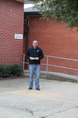
A photograph of Mark Osborne, a member of the Wellington Emergency Management Office, outside the office block of St Paul's School in Dallington.

Liquefaction silt in Bexley. The photographer comments, "This is not really a worm but a sliver of liquefaction that has fallen out of a tyre tread".

A photograph of an abandoned property at 72 Arncliff Street in Bexley. Wooden bracing is supporting the garage and a broken office chair is lying in the driveway.

A photograph of the former site of Donna Allfrey's house at 406 Oxford Terrace. Allfrey's house was demolished after her land was zoned Red.

A portaloo on the side of Kingsford Street in the Horseshoe Lake District. Signs with "Merry Christmas" and "Santa's Grotto" have been taped to the side.

Photograph captioned by BeckerFraserPhotos, "15 Waygreen Avenue in New Brighton, now red zoned land. The homeowner still lives in this property and is keeping it in immaculate condition".

A photograph captioned by BeckerFraserPhotos, "A view looking south along Wattle Drive, New Brighton towards the Port Hills. This part of the street is red zoned".

A photograph captioned by BeckerFraserPhotos, "Wattle Drive in New Brighton. This part of the street is red zoned. This red zoned house is on the boundary between the zones".

Contractors conferring on the Anzac Drive Bridge in New Brighton. In the background, an excavator is lifting a piece of metal to place on one of the bridge's lamp posts.

A photograph captioned by BeckerFraserPhotos, "A residential property on the corner of Jean Batten Place and Liggins Street in the Horseshoe Lake district".

An aerial photograph of a residential area in Bexley. In the distance, the New Brighton pier can be seen as well as the Rawhiti Domain and Bottle Lake Forrest.

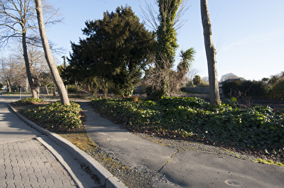
A photograph looking north along the footpath of Bangor Street. To the right there are the former sites of several houses. The houses were demolished after the land was zoned Red.

A photograph of the former sites of several houses on Bangor Street. The houses were demolished after the land was zoned Red.

An aerial photograph of New Brighton Road, where the traffic has been diverted across the front yards of several red-zoned houses.

A photograph captioned by BeckerFraserPhotos, "Residential properties on Kingsford Street in the Horseshoe Lake district". A sign on a power pole reads, "Viewing. Kiwi - $2, tourist - $5".