
Search
found 558 results
20160307_6607_7D2-110 Interior removal
Images, eqnz.chch.2010
The Forsyth Barr building has stood silent and empty (except the occasional intruder and pigeons) since the February 2011 earthquake. It was sold "as is" and I understand that it is now going to be fitted out as a hotel. This is the building that had severe stairwell damage during the quake necessitating people being lowered via ropes etc on t...
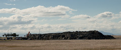
20110307_2009_1D3-85 Liquefaction silt pile [EQNZ]
Images, eqnz.chch.2010
This is a temporary pile of silt piled on the old Bexley landfill sight. Some trucks are addng to the pile, while other truck and trailer units are taking it away to the old Bottle Lake landfill sight, a few km to the north of here.

The Wobbly Jetty - 2
Images, eqnz.chch.2010
20160415_0044_1D3-38 The Wobbly Jetty - 2 The South New Brighton jetty was rebuilt a couple of years before the earthquakes wrecked it. Was closed to the public for about four years but is open now. #7222

20120128_8071_1D3-400 Redcliffs wall
Images, eqnz.chch.2010
The sea wall at Beachville Road, Redcliffs, after the earthquake. It used to be straight and level - not now! As a teenager I went fishing off this wall.

20110228_1595_1D3-24 The Clean Up [EQNZ]
Images, eqnz.chch.2010
Cleaning up Manning Signs of the silt from liquefaction. Three fellow workers man the shovels while two building engineers talk to the boss (hidden). After doing the car park we then turned our hands to the inside of the factory, once clearance was given that we could go inside.

20160613_0044_7D2-100 Jetty Closed
Images, eqnz.chch.2010
The South New Brighton jetty has been closed for 3 or 4 years (fenced off) then the fence was removed and it was "open", but nothing has happened to it since the earthquakes, but it is closed again now, although it looks like a home made sign!

20130704_7680_EOS M-22 Another one on the way out!
Images, eqnz.chch.2010
The Mack tractor unit with "half a house" ready to depart in the middle of the night, when the roads are quiet. But where is this house heading too?

20140904_9091_EOS M-22 23 Velsheda Street today (2014)
Images, eqnz.chch.2010
Today (04/09/14) marks the fourth anniversary since the first earthquake rocked the city and greater Christchurch area. That first quake was magnitude 7.1, and luckily there was only one fatality (possible a heart attack). Since then we have had over 14,000 quakes, most very small in magnitude, but well over 500 of magnitude 4 or greater. 5...

20140112_7509_1D3-70 Remains (My City in Ruins) (SH 8)
Images, eqnz.chch.2010
Scavenger Hunt 101 - SH 8 (abandoned building or ruin) The ruins/remains of what was the third highest building in Christchurch, pre earthquakes, the Price Waterhouse Coopers building in Armagh Street. At 76.3 metres ( 21 floors) the demolition has left the basement (now flooded) and these supports. Just one of many photos from Christchurch ...

20131014_4128_1D3-40 Polluted Water (Day 287/365)
Images, eqnz.chch.2010
There are occasional sewerage spills into the Avon River while all the sewer and road repairs are carried out. This rock wall was level and well above high tide level prior to the eathquakes. All the houses that can been seen here (except for those on the distant Port Hills) are in the suburban "red zone" and are still to be demolished.

Twelve Days of Christmas (part 2)
Images, eqnz.chch.2010
20131228_6787_1D3-82 Twelve Days of Christmas (part 2) The NG building on Madras Street was given the go ahead to repair earthquake damage, which the owners did at some expense, Now, the government want this land to build a central city stadium, so there is a protest on the windows set to the Christmas song the Twelve Days of Christmas. 12 mi...

The old Odeon Theatre
Images, eqnz.chch.2010
20131228_6797_1D3-58 The old Odeon Theatre The back of the old Odeon movie theatre, that was for about 15-20 years a New Life Christian Centre. This is earthquake damage, although the roof was lifted off in 2011. I don't know whether this is a building that they want to save or still awaiting demolition. The smaller building to the immediate...
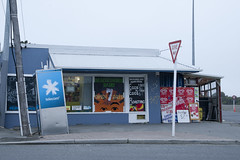
20120321_2397_1D3-47 Beachcomber Dairy
Images, eqnz.chch.2010
20120321_2397_1D3-47 Beachcomber Dairy Corner of New Brighton Road and Rawson Street, New Brighton. This diary is inside the suburban red zone and will probably be demolished some time in the future. See how the earthquakes have moved the footpath - the post and phone box used to stand straight! This is one of the Teleccom Wi-Fi hotspot boo...

20130627_8878_1D3-28 We need the Pot of Gold!!
Images, eqnz.chch.2010
On the day the the government and council jointly announced who will fund what, for the Christchurch rebuild, a rainbow appears over the rebuild of the Latimer Hotel. For the central city the figures are: NZ$4.9 billion with $2.9 billion coming from central government and $1.9 billion coming from the local city council (us ratepayers in Christc...

20111229_7210_1D3-195 Bexley Wetlands and Pacific Park
Images, eqnz.chch.2010
The flooded Bexley Wetlands, now about 1 - 1.5metre below pre earthquake level. The short length of fence (mid ground) was on the "river track" that the council closed about three years ago. The whole track in this view is now under about 500mm water at high tide. The main track in front of the houses was, prior to earthquakes, below the leve...

20130627_8864_1D3-32 Pay Here
Images, eqnz.chch.2010
Maybe it should be titled "Pray Here"! The old church buildings next to the Christchurch Basilica (Cathedral of the Blessed Sacrament) have been demolished and replaced with ANOTHER Wilson's Car Park. Hundreds of sites in the city where buildings have been demolished after the earthquakes have been replaced in the short term by car parks!

20130524_7214_1D3-40 Hidden park bench
Images, eqnz.chch.2010
Prior to the earthquakes (mainly the February 22 2011 event) this park bench was at track level. Shortly after the February quake someone in the council did the sums and realised that the area near the Avon River had dropped between a metre and 1.4m (about 4 foot), so a rush job by contractors shifted in many tonnes of rock and gravel to raise a...

20131212_6234_1D3-24 Another New Brighton building comes down (Day 346/365)
Images, eqnz.chch.2010
20131212_6234_1D3-24 Another New Brighton building comes down (Day 346/365) The old Esplanade Tavern is being demolished due to damage suffered in the earthquakes of 2011. Another one of New Brighton's iconic buildings to go. #4457

20140110_7484_1D3-40 Avon River and earthquake damage
Images, eqnz.chch.2010
Low tide on the Avon River at New Brighton/Bexley. Note the original bank and the rock wall slipage on right. The white additions were added in March and April 2011 to protect the properties behind from flooding. Ultimately this area was "red zoned" with all houses removed or to be removed and the ground left till a rehabilitation method can ...

20130901_2869_1D3-150 Wilson City!
Images, eqnz.chch.2010
As buildings are demolished as a result of the earthquake in 2011, Wilson Carparking are waiting to pounce on each bit of vacant land. Someone suggested about a year ago that the city be renamed "Wilson" as that name appears more in the central city than Christchurch does! In the background the CERES NZ nibbler attacks the support structure fo...

It has started!
Images, eqnz.chch.2010
20140521_1080_1D3-24 It has started! Removal of the double-glazed windows is underway at my "red zone" house, now owned by the Government of New Zealand. Sold to CERA (the government agency) in October 2012 and has remained empty since, despite having little damage, apart from the tilt to the front from the land damage that occurred during the...

20140927_2219_1D3-24 Planting natives at Harold Henry Park
Images, eqnz.chch.2010
20140927_2219_1D3-24 Planting natives at Harold Henry Park A planting of native bushes and trees in the old children's playground area in Bexley, Organised by the Facebook group Avon River Park and assisted by ex Bexley residents. This is right in the middle of the Bexley red zone with most houses removed or demolished now. #5832

20141005_2502_1D3-40 CTV site
Images, eqnz.chch.2010
The sign reads: The CTV Building was headquarters of Canterbury Television (CTV) and also housed King’s Education language School, a medical clinic, Hair Consultants, Relationship Services and a nursing school. On February 22nd 2011 the building collapsed as a result of a major earthquake. Sadly, 115 people who were in the building lost their l...

Porritt Park
Images, eqnz.chch.2010
20160104_1602_7D2-20 Porritt Park Porritt Park was, before the earthquakes, the headquarters of hockey in this region. Two astro-turf fields (the main one was to the left of the building), and corporate offices etc. The earthquakes buckled all the playing surfaces and damaged the buildings; a couple of smaller ones have been removed. Hocke...

Red Zone Closures
Images, eqnz.chch.2010
20160415_0029_1D3-24 Red Zone Closures The permanent closure (to motor vehicles) of the Bexley red zone streets has started. This was once the main south-north route just west of the Avon River in the New Brighton area, till an expressway (ring road) was built about 80m to the west (right) about 12-13 years ago. Then it became just another ...

20160612_8429_1D3-40 Abandoned and maybe forgotten
Images, eqnz.chch.2010
AMI Stadium (Lancaster Park), not used since the February 2011 earthquake. It was used predominantly for rugby and cricket. We are still waiting to see what the outcome is for this stadium. Government want a new one closer to the CBD, so there is talk of this being demolished, while others want it repaired. The concrete pad lower left is ...

Trees in the Red Zone (307/365)
Images, eqnz.chch.2010
20171103_5582_1D3-38 Trees in the Red Zone (307/365) In what used to be sections with houses and yards. Between late 2011 and 2014 the houses (well 95% of them) were removed due to land dropping in the 2011 earthquakes and the proximity of the Avon River, tidal in this area. #8859

20130610_7555_EOS M-22 19 Velsheda Street
Images, eqnz.chch.2010
Being prepared for removal. Is in red zone so has to go.d The house had minimal damage, but the land it was on was deemed to be no good - red zoned.

20130511_1535_EOS M-22 Captain Cook (Day 131/365)
Images, eqnz.chch.2010
The statue of Captain Cook looks over an empty Victoria Square with autumn leaves lying around. This used to be a very tidy and busy area, but is now nearly all fenced off. Pedestrian access to this section was established about five or six months ago.

Where once stood houses (Day 348/365)
Images, eqnz.chch.2010
20131214_6268_1D3-24 Where once stood houses (Day 348/365) The area beside the lower Avon River in New Brighton of Evans Avenue and Admirals Way has been cleared of houses and boundary fences (there were between 15 and 20 houses on this block) , fully fenced with post and wire and "spray on" grass applied. These were all red zone properties a...