
One landscape colour digital photograph taken on 27 May 2013 of London Street in Lyttelton. Taken from Sumner Road looking west across the intersection of London and Oxford Streets. The photograph shows several empty sections and the remaining buildings. The Lyttelton streetscape has changed dramatically from its pre-earthquake appearance and w...
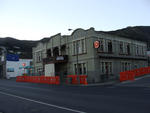
One landscape colour digital photograph taken on 26 May 2013 on the corner of Norwich Quay and Canterbury Street, Lyttelton. The photograph shows the Mitre Hotel surrounded by temporary fencing. Three years after the 2010-2011 earthquakes there are still many uncertainties about which buildings can or will be retained. These buildings, or parts...
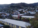
One landscape colour digital photograph taken on 26 May 2013 of Lyttelton Main School. The photograph is taken from St Davids Street looking northwest. One of the broader consequences of the 2010-2011 Canterbury earthquakes has been the Ministry of Education’s Shaping Education – Future Direction Review of Schools in the Greater Christchurch Ar...

Canterbury Brewery, St Asaph Street, Christchurch.
File reference:
CCL-2012-02-20-CanterburyBrewery-February-2012 DSC_144.JPG
From the collection of Christchurch City Libraries.

Canterbury Brewery, St Asaph Street, Christchurch.
File reference:
CCL-2012-02-20-CanterburyBrewery-February-2012 DSC_147.JPG
From the collection of Christchurch City Libraries.

Canterbury Brewery, St Asaph Street, Christchurch.
File reference:
CCL-2012-02-20-CanterburyBrewery-February-2012 DSC_142.JPG
From the collection of Christchurch City Libraries.

Canterbury Brewery, St Asaph Street, Christchurch.
File reference:
CCL-2012-02-20-CanterburyBrewery-February-2012 DSC_146.JPG
From the collection of Christchurch City Libraries.

Canterbury Brewery, St Asaph Street, Christchurch.
File reference:
CCL-2012-02-20-CanterburyBrewery-February-2012 DSC_143.JPG
From the collection of Christchurch City Libraries.

Canterbury Brewery, St Asaph Street, Christchurch.
File reference:
CCL-2012-02-20-CanterburyBrewery-February-2012 DSC_145.JPG
From the collection of Christchurch City Libraries.

A view after the 7.1 magnitude earthquake in Christchurch.

A report card rating the Earthquake Recovery Minister's handling of the Canterbury earthquakes.

Canterbury Earthquake 04/09/10
Christchurch
New Zealand

Earthquake aerial photo taken by Jude Lathey, 6 September 2010.

One twisted rectangular metal sign engraved with the words 'Pyne Gould Corporation' in black. Recovered from the Pyne Gould Corporation Building following the 22 February earthquake. The Pyne Gould Corporation (PGC) building, which was located on Cambridge Terrace in central Christchurch, collapsed during the 22 February 2011 earthquake with 18...
One landscape colour digital photograph taken on 25 February 2011 showing earthquake damage to the premises of Ground Delicatessen on the corner of Canterbury and London Streets. The photograph shows the building's Canterbury Street façade. This building was initially built around 1864 as the Albion Hotel. After many modifications and changes ...

A photograph of a SPCA Wellington vehicle driving through the Christchurch central city after the 22 February 2011 earthquake. In the background, a group of shops has been damaged by the earthquakes. A portaloo can be seen to the left.

A photograph of the Animal Rescue Unit preparing to drop off food at welfare centres and other sites in earthquake affected areas after the 22 February 2011 earthquake. In the background, a member of SPCA Canterbury is being interviewed by TVNZ.

Aftermath of September 4th Earthquake in Canterbury (area covers Christchurch City) NZ. Damage to bridge on Spencerville Road crossing the Lower Styx river.
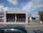
One landscape colour digital photograph taken on 19 November 2011 showing the Lyttelton Fire Station. The building is fenced off and unused due to earthquake damage. To the right of the photograph the front of one of the Fire Appliances and the shipping containers set up in the rear car park to provide temporary facilities can be seen. Followin...

One landscape colour digital photograph taken on 19 November 2011 showing the temporary premises of the Bank of New Zealand in a relocatable building on the footpath. The sign above the tellers window read "Lyttel Bank" The Lyttelton streetscape has changed dramatically from its pre-earthquake appearance and will continue to change as new build...

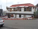
One landscape colour digital photograph taken on 19 November 2011 showing the site of the old Lyttelton Library, Council Chambers and Magistrates' Court on the corner of Oxford Street and Sumner Road. At the time of the 22 February 2011 Earthquake the building was in private ownership and was the premises of Moda Fotografica and a private resid...

One landscape colour digital photograph taken on 27 May 2013 of a retaining wall in Sumner Road which was replaced due to earthquake damage. The original wall was created using red volcanic rock. Many walls like this were built using the Hard Labour Gang from the Lyttelton Gaol. The replacement wall has a small section of stone installed to sho...

One landscape colour digital photograph taken on 27 May 2013 of a retaining wall in Sumner Road which was replaced due to earthquake damage. The original wall was created using red volcanic rock. Many walls like this were built using the Hard Labour Gang from the Lyttelton Gaol. The replacement wall has a small section of stone installed to sho...

One landscape colour digital photograph taken on 25 September 2011 showing the site of the Lyttelton Historical Museum on the corner of Gladstone Quay and Donald Street. The photograph shows the temporary fencing around the levelled site. The building visible at the rear is the former Municipal Stables on Donald Street. To the right of the phot...

One landscape colour digital photograph taken on 30 June 2011 showing signs warning of the danger posed by unstable headstones in Lyttelton Roman Catholic and Dissenters (Public) Cemeteries in Reserve Terrace. Several toppled headstones and collapsed grave surrounds are visible in the photograph. Looking east from the main gate. The Lyttelton c...

One carved wooden corner bracket from Hadleigh House. Owner of Hadleigh House 1904-1921

Aftermath of September 4th Earthquake in Canterbury (area covers Christchurch City) NZ. Empty fuel tanks lifted out of forecourt at petrol station on Pages Road.

Earthquake aerial photo taken by Jude Lathey, 6 September 2010.

Earthquake aerial photo taken by Jude Lathey, 6 September 2010.

Earthquake aerial photo taken by Jude Lathey, 6 September 2010.