
Search
found 2908 results
Digital Photograph: Grubb Cottage, London Street, Lyttelton
Images, Canterbury Museum
One landscape colour digital photograph taken on 19 November 2011 showing Grubb Cottage on London Street. The rear portion of this building was built in 1851 and is regarded as one of the oldest buildings in Canterbury. It was sold in 2006 to the Christchurch City Council and vested in the Grubb Cottage Heritage Trust. In August 2013 the buildi...

Digital Photograph: Temporary Bank of New Zealand Branch, north side of Lo…
Images, Canterbury Museum
One landscape colour digital photograph taken on 19 November 2011 showing the temporary premises of the Bank of New Zealand in a relocatable building on the footpath. The sign above the tellers window read "Lyttel Bank" The Lyttelton streetscape has changed dramatically from its pre-earthquake appearance and will continue to change as new build...

Digital Photograph: Corner of London and Canterbury Streets, Lyttelton
Images, Canterbury Museum
One landscape colour digital photograph taken on 19 November 2011 showing the corner of London and Canterbury Streets. Visible in the photograph (left to right) are the Lyttelton Library, Freemans Dining Room, Ray White Real Estate and Min Sargison Real Estate on London Street. The photograph is looking to the southeast. The site of the Timebal...

Digital Photograph: Temporary Artwork on the corner of London and Canterbu…
Images, Canterbury Museum
One landscape colour digital photograph taken on 19 November 2011 showing a temporary artwork on the site of the Albion Hotel/ Ground Delicatessen. After the demolition of the building the site was used for a Gap Filler initiative called the Lyttelton Petanque Club. The photograph shows a temporary artwork created from used bricks, probably from...

Digital Photograph: The Loons (Lyttelton Working Mens' Club), Canterbury S…
Images, Canterbury Museum
One landscape colour digital photograph taken on 19 November 2011 showing temporary propping of the Lyttelton Working Mens' Club/ The Loons. Built in 1909 the building has had a variety of uses including a garage and the Lyttelton Waterside Workers Social Club. More recently the Lyttelton Working Mens' Club has provided rehearsal and performanc...

Digital Photograph: Lyttelton Sea Foods, Norwich Quay, Lyttelton
Images, Canterbury Museum
One landscape colour digital photograph taken on 19 November 2011 showing the temporary premises of Lyttelton Sea Foods in a relocatable building on Norwich Quay. The building is located on the site of the Lyttelton Hotel. Also visible in the photograph are (left to right) the side of Shadbolt House, the rear of the Pacifica Building which was t...

Digital Photograph: Lyttelton Bakery, corner Norwich Quay and Canterbury S…
Images, Canterbury Museum
One landscape colour digital photograph taken on 19 November 2011 showing the temporary premises of Lyttelton Bakery in a relocatable building on Norwich Quay. The building is located on the site of the Royal Hotel. Also visible in the photograph are (left to right up Canterbury Street) Lyttelton Service Station, Samo, Lyttelton Telephone Exchan...

Digital Photograph: Earthquake Damage to Lyttelton Historical Museum, Glad…
Images, Canterbury Museum
One landscape colour digital photograph taken on 25 September 2011 showing the site of the Lyttelton Historical Museum on the corner of Gladstone Quay and Donald Street. The photograph shows the temporary fencing around the levelled site. The building visible at the rear is the former Municipal Stables on Donald Street. To the right of the phot...

Digital Photograph: Artwork on the Site of the Harbourlight Theatre, Londo…
Images, Canterbury Museum
One portrait colour digital photograph taken on 23 July 2011 showing the artwork by Trent Hiles erected on the site of the Harbourlight Theatre on London Street. The artwork presents part of James K Baxter's poem 'High Country Weather' using the international code of signal flags. The artwork was installed as a Gap Filler project. The artwork r...

Digital Photograph: Earthquake damage to Church of the Most Holy Trinity, …
Images, Canterbury Museum
One landscape colour digital photograph taken on 15 June 2011 showing earthquake damage to the Anglican Church of The Most Holy Trinity in Winchester Street, Lyttelton. Photograph shows collapsed roof of the nave and north transept. Photograph taken from the north side of the church. Architect The collapse of the Church of the Most Holy Trinity ...
Digital Photograph: Earthquake Damage to Lyttelton Roman Catholic and Diss…
Images, Canterbury Museum
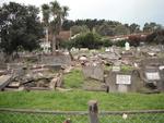
One landscape colour digital photograph taken on 30 June 2011 showing earthquake damage to graves in Lyttelton Roman Catholic and Dissenters (Public) Cemeteries in Reserve Terrace. Most of the headstones and grave surrounds in the photograph show damage. Looking east in the Dissenters (Public) section of the cemetery. The Lyttelton cemeteries a...

Digital Photograph: Earthquake Damage to Lyttelton Roman Catholic and Diss…
Images, Canterbury Museum
One landscape colour digital photograph taken on 30 June 2011 showing signs warning of the danger posed by unstable headstones in Lyttelton Roman Catholic and Dissenters (Public) Cemeteries in Reserve Terrace. Several toppled headstones and collapsed grave surrounds are visible in the photograph. Looking east from the main gate. The Lyttelton c...

Digital Photograph: Earthquake damage to a retaining wall, Lyttelton
Images, Canterbury Museum
One landscape colour digital photograph taken on 30 June 2011 showing earthquake damage to a section of retaining wall in Sumner Road. Plastic sheeting installed to stabilise previous damage and protect from water erosion is visible to the right of the photograph. Also visible in the photograph is a boarded up broken window and temporary safety ...

Digital Photograph: Earthquake damage to Church of the Most Holy Trinity, …
Images, Canterbury Museum
One landscape colour digital photograph taken on 15 June 2011 showing earthquake damage to the Anglican Church of The Most Holy Trinity in Winchester Street, Lyttelton. Photograph shows collapsed roof of the nave and north transept. Photograph taken from the northwest corner of the church. Architect The collapse of the Church of the Most Holy Tr...

Digital Photograph: Demolition of former Library and Fire Station, corner …
Images, Canterbury Museum
One landscape colour digital photograph taken on 6 September 2011 showing the demolition of 2 Sumner Road, the former library and fire station. This building was a private residence at the time of its demolition. Photograph taken looking north on Oxford Street. Also visible in the photograph are the Lyttelton Information Centre, an entrance to ...
Hawkey, Allan Charles, 1941- :[Helping after the Christchurch earthquake] …
Images, Alexander Turnbull Library
The cartoon shows an arm clothed in a blue shirt which is covered with the printed names of all the people and organisations who have provided assistance to the people of Christchurch since the earthquake of 22 February 2011. The include 'neighbours', 'charities', 'communities', 'church groups etc. Quantity: 1 digital cartoon(s).
Photograph by Neil Macbeth 630
Images, UC QuakeStudies
Felled trees near the Park Terrace bridge in Hagley Park. A lamp post in the background is on a noticeable lean and a damaged shipping container can be seen to the left. The shipping container was damaged when the tree fell during the 22 February 2011 earthquake.
Observatory Tower Photograph 29
Images, UC QuakeStudies
A photograph of an earthquake-damaged suitcase in the South Quad of the Christchurch Arts Centre. The suitcase is resting on a pile of scaffolding which had been constructed around the Observatory tower. The scaffolding collapsed along with the tower during the 22 February 2011 earthquake.
Elizabeth Ackermann Photograph 209
Images, UC QuakeStudies
A photograph of workers in fluorescent vests standing in front of the earthquake damaged McKenzie and Willis Building. The photograph was taken on 29 April 2011 during the Residential Access Project which gave residents temporary access within the red-zone cordon in order to retrieve items from their homes after the 22 February 2011 earthquake.
Image 2 - Earthquake!
Images, UC QuakeStudies
An image from a Navy Today April 2011 article titled, "Earthquake!". The image is of a Unimog truck disembarking from the HMNZS Canterbury via a side ramp in the early evening of 22 February 2011. The truck was draped in camouflage netting in preparation for a planned field exercise. The exercise was cancelled due to the earthquake.

Digital Photograph: Queenstown 12.51pm
Images, Canterbury Museum
One landscape colour digital photograph taken on 1 March 2011 showing the road between Franklin and Queenstown with an electronic road work sign depicting the words '12.51pm 2 minutes silence'. People all around New Zealand participated in gestures of support for Christchurch following the 6.3 magnitude earthquake on 22 February 2011. In Queens...
WEMO ERT Set 1 - March 2011 - Photograph 58
Images, UC QuakeStudies
A photograph of members of the Wellington Emergency Management Office Emergency Response Team in the hanger of a Royal New Zealand Air Force Hercules. The ERT members are travelling to Christchurch to help out in the emergency response to the 22 February 2011 earthquake. Blankets, tent poles, and other supplies have been stacked in the centre of the hanger.
NicksPlace Photograph 224
Images, UC QuakeStudies
Building rubble behind cordon fencing at the corner of Salisbury and Montreal Streets. In the background is the Victoria Clock Tower, with the clock stopped at 12:51, the time of the 22 February earthquake.
The Strange Forces that Earthquakes Create
Images, UC QuakeStudies
Liquefaction and buckled tarmac on a residential street in North New Brighton. The photographer comments, "In the February 2011 earthquake in Christchurch the kerb at the end of my road was pushed from both ends. This caused it to move away from the grass verge and push itself under the tarmac. The tarmac would normally have been 3 inches below the top of the kerb. Between the kerb and the grass can be seen the colour of the liquefaction that spewed out from the ground. The tarmac in the area seemed to flow downhill".
The Gap Filled
Images, UC QuakeStudies
A paint-splattered chair sits in front of a brightly-coloured piano painted with a cat's face, part of Gap Filler's Painted Piano Project. The photographer comments, "Gap filler I believe has created three sites filled with a stage area, seating and a piano. This one is at the Junction of Bower Ave and Marine Parade on the site of the demolished TJs Kazbah and opposite the now demolished Ozone. They have really brightened the corner up and we just need a few people to gather and have a nice night of it".
Umut Akguzel Photograph 075
Images, UC QuakeStudies
A photograph of the earthquake damage to Poplar Street taken from Tuam Street shortly after the 22 February 2011 earthquake. The road is completely covered by loose bricks and a car has been crushed. To the left, the corner of a building has collapsed, rubble falling into the street.
QuakeStory Photo 562
Images, UC QuakeStudies
A photograph submitted by Andrew Panckhurst to the QuakeStories website. The description reads, "Peter Symms being cared for shortly after being rescued by Mike Ryan (with blooddy jacket) from the Regent Building in Cathedral Square on 22 February 2011. Originally posted on the CHCH EQ Photos Facebook page".
22 February Earthquake - Photograph 73
Images, UC QuakeStudies
The damaged Carlton Hotel. The parapet and part of the upper storey has collapsed.
As Free as a Caged Bird
Images, UC QuakeStudies
An advertising poster outside Minx Dining Room and Bar on Lichfield Street depicts Katy Perry in a bird cage. The photographer comments, "One of the sites you will see on the Christchurch CBD red zone tour".
All Right? Social Media: Facebook Profile Picture 5
Images, UC QuakeStudies
An image used as a profile picture on the All Right? Facebook page. The image reads, "We (heart) Canterbury 22 Feb 2011." All Right? posted the image on their Facebook page on 20 February 2014 at 6:56am.