Search
found 2250 results
Three Leaf Clover
Images, UC QuakeStudies
Graffiti on a damaged building. The photographer comments, "They should have painted four leaf clover, if they wanted this tagging to survive the demolition of the earthquake damaged Ozone in Christchurch
Rebekah Rogers WEMO Photograph 026
Images, UC QuakeStudies
A photograph of an open sign for CIRA Coffee & Wares on a residential street in the Christchurch central city. The café was set up in a house after the 22 February 2011 earthquake.
New Zealand Defence Force photograph 762
Images, UC QuakeStudies
The Cathedral of the Blessed Sacrament on Barbadoes Street, severely damaged after the 22 February 2011 earthquake. The domes on either side of the Cathedral have collapsed and are lying in the area in front.

Memorial Guitar: Kia Kaha
Images, Canterbury Museum
One white over-painted hand-made electric guitar made primarily from ash and maple timbers, also incorporating wood from a variety of historic buildings in Canterbury damaged or destroyed in the 2010 - 2011 earthquakes including the Arts Centre, Kutwell’s Warehouse, Lyttleton main street pub, Timeball Station, Carlton Hotel, Merivale shops, bui...
Manawatu Standard Image: Stacy Squires 2010:12:13 10:10:00
Images, UC QuakeStudies
Photograph captioned by Fairfax, "Christchurch CBD was 'yarn-bombed' during the weekend using yarn and fabric pieces to brighten public areas and earthquake-affected spaces. Hope sign at Hereford and Manchester Streets".
Kim Wright WEMO Photograph 046
Images, UC QuakeStudies
A photograph of an earthquake damaged road in Christchurch. Road cones, cracks, and the remants of liquefaction can be seen on the road. There is a queue of traffic along the street.
SPCA Canterbury Photograph 25
Images, UC QuakeStudies
A photograph of members of Massey University's Veterinary Emergency Response Team (VERT) working in the central city red zone after the 22 February 2011 earthquake. VERT travelled to Christchurch after the 22 February 2011 earthquake in order to assist with caring for animals. Each member is wearing a hard hat, face masks, and a head lamp.

Just a Shell of Its Self
Images, eqnz.chch.2010
Earthquake damaged building on a Walk around the city, May 1, 2014 Christchurch New Zealand. Demolition work on Christchurch's "distinctive" former civic building is under way. The category-2 heritage building was designed by G A J Hart and opened in 1939 as the Miller's department store. It featured the South Island's first escalator, which...
No 8, Merchants of Fine Wine
Images, UC QuakeStudies
A digitally manipulated photograph of a building on Poplar Lane. The photographer comments, "I felt that this building had a real Italian feel about it. It is actually in Christchurch, New Zealand. It appears on the list to be partially demolished after the Christchurch earthquake, so it might not be around for much longer".

The story of Christchurch (Day 229/365)
Images, eqnz.chch.2010
20130817_2457_1D3-400 The story of Christchurch (Day 229/365) Many roads are closed all over eastern Christchurch as infra-structure repairs are carried out, whether it be water supplies, sewer repairs (as is the case here) or general road repairs, In just over two weeks it will be three years since the first earthquake happened (4th September...
IRD building and 185 white chairs
Images, eqnz.chch.2010
20130403_2911_G12-10 IRD building and 185 white chairs Corner of Cashel and Madras streets, with the relatively new (built 2007) Inland Revenue Building and the white chair memorial to the 185 lives lost as a result of the 22/02/11 earthquake. The chairs sit on the site of the now demolished St Pauls Pacific Chuch and is diagonally across the i...

A new crack in the footpath in Rydal Park.
Images, eqnz.chch.2010
Cracks in the roads and foot paths were surprisingly hard to find given the strength of the earthquake.
WEMO ERT Set 1 - February 2011 - Photograph 53
Images, UC QuakeStudies
A photograph of the earthquake damage to the back of the Canterbury Provincial Chambers, taken from Oxford Terrace across the Avon River.
The Southland Times Image: Stacy Squires 2010:12:13 10:03:28
Images, UC QuakeStudies
Photograph captioned by Fairfax, "Christchurch CBD was 'yarn-bombed' during the weekend using yarn and fabric pieces to brighten public areas and earthquake-affected spaces. Hope sign at Hereford and Manchester Streets".
The Southland Times Image: Stacy Squires 2010:12:13 10:04:02
Images, UC QuakeStudies
Photograph captioned by Fairfax, "Christchurch CBD was 'yarn-bombed' during the weekend using yarn and fabric pieces to brighten public areas and earthquake-affected spaces. Hope sign at Hereford and Manchester Streets".
WEMO ERT Set 1 - March 2011 - Photograph 71
Images, UC QuakeStudies
A photograph of the earthquake damage to the Iconic Bar and the former Christchurch City Council offices on Manchester Street. The outer walls of the Council offices and the top storey of Iconic have collapsed, exposing the insides of the buildings. The bricks and other rubble have been cleared from the footpath in front. USAR codes have been spray-painted next to the entrance of Iconic.
Christchurch Press Image: Iain McGregor 2010:09:06 00:24:54
Images, UC QuakeStudies
Photograph captioned by Fairfax, "Major earthquake hits Christchurch. Maling Street in Avonside. From left: Ngarita Briggs (8), Walton Briggs and Paula Grant sit under a makeshift shelter while they wait for a wood fire to boil water. They are too scared to go in the house so are sleeping on the lawn".
Christchurch Press Image: Iain McGregor 2010:09:06 00:23:20
Images, UC QuakeStudies
Photograph captioned by Fairfax, "Major earthquake hits Christchurch. Maling Street in Avonside. From left: Charlie Tarawa, Tamatea Briggs (12) and Ngarita Briggs (8) sit under a make-shift shelter while they wait for a wood fire to boil water. They are too scared to go in the house so are sleeping on the lawn".
WEMO ERT Set 2 - February 2011 - Photograph 02
Images, UC QuakeStudies
A photograph of volunteers from the Wellington Emergency Management Office preparing for their journey to Christchurch after the 22 February 2011 earthquake. In the background is the Wellington Emergency Management Office building.
WEMO ERT Set 2 - February 2011 - Photograph 01
Images, UC QuakeStudies
A photograph of volunteers from the Wellington Emergency Management Office preparing for their journey to Christchurch after the 22 February 2011 earthquake. In the background is the Wellington Emergency Management Office building.
WEMO ERT Set 3 - February 2011 - Photograph 004
Images, UC QuakeStudies
A photograph of volunteers from the Wellington Emergency Management Office preparing for their journey to Christchurch after the 22 February 2011 earthquake. In the background is the Wellington Emergency Management Office building.

20130630_9138_1D3-58 IRD Building (Day 181/365)
Images, eqnz.chch.2010
The old (or is that the new) Inland Revenue Department (IRD) building on the corner of Madras and Cashel Streets in central Christchurch. Built in 2006/07 on the site of the former Farmers department store (itself badly damaged by fire), it was just a few years old when the earthquake of February 2011 struck, and subsequent quakes (all through 2...

20120702_1387_G12-18 Another one bites the dust
Images, eqnz.chch.2010
8 Velsheda Street, Bexley, Christchurch, across the road from my house was demolished a week or so ago, just one of many demolitions of Red Zone properties at the moment. This house was about ten years old and suffered land damage during the 4th September 2010 and 22nd February 2011 earthquakes. The same fate awaits my house later in the year o...
Kim Wright WEMO Photograph 060
Images, UC QuakeStudies
A photograph of volunteers fron the Wellington Emergency Management Office walking down an earthquake damaged street in Christchurch. In the background, one of the houses has a yellow sticker, indicating that access is restricted.

Digital Photograph: Hagley Park
Images, Canterbury Museum
One landscape colour digital photograph taken on 6 September 2010 showing water table alteration in a view towards Park Terrace from Hagley Park, near the Armagh Street bridge. Localised flooding was an almost immediate after effect of the 2010-2011 Canterbury earthquakes. Some areas of Christchurch were submerged, sometimes for several days, f...
Helen Devereux Photograph 070
Images, UC QuakeStudies
For the first time in November 2011, Christchurch residents finally had the opportunity to see the earthquake-damaged city centre on the Red Zone bus tours organised by CERA. Damage to buildings on Cashel Street can be seen out the window.

Digital Photograph: Lyttelton Main School from the Gaol Steps, Lyttelton
Images, Canterbury Museum
One landscape colour digital photograph taken on 13 May 2011 showing Lyttelton Main School viewed from above near the top of the Gaol Steps between Oxford and St Davids Streets. The photograph is taken at an angle. Several subsequently demolished buildings are visible beyond the school including (from left to right) Lyttelton Police Station, th...

the day after
Images, eqnz.chch.2010
Cleaning up the silt and sand from Hoon Hay properties. Here Laura, Robbie, and Ronny are part of the clean-up crew on Wyn Street.

Digital Photograph: View looking northwest from the Gaol Steps, Lyttelton
Images, Canterbury Museum
One landscape colour digital photograph taken on 13 May 2011 looking northwest from the Gaol Steps. In the foreground is the edge of the Lyttelton Rose Garden, the safety fencing around the Upham Clock is visible. Below this is the intersection of Winchester and Oxford Streets. Prominent in the mid ground are the Catholic Church of St Joseph the...
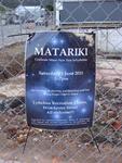
Digital Photograph: Sign Advertising a Matariki celebration in Lyttelton
Images, Canterbury Museum
One portrait colour digital photograph taken on 8 June 2011 of a sign advertising Matariki Celebrations in Lyttelton. The sign is a printed piece of paper which has been laminated and attached to the fence on the site of the Volcano Restaurant on the corner of London and Canterbury Streets. The cleared site is visible through the fence in the ba...