
An aerial photograph of Christchurch following the 4 September earthquake, taken from a helicopter.

An aerial photograph of rural Canterbury following the 4 September earthquake, taken from a helicopter.

An aerial photograph of rural Canterbury following the 4 September earthquake, taken from a helicopter.

An aerial photograph of rural Canterbury following the 4 September earthquake, taken from a helicopter.

An aerial photograph of rural Canterbury following the 4 September earthquake, taken from a helicopter.

An aerial photograph of rural Canterbury following the 4 September earthquake, taken from a helicopter.

An aerial photograph of the Port Hills following the 4 September earthquake, taken from a helicopter.

An aerial photograph of rural Canterbury following the 4 September earthquake, taken from a helicopter.

An aerial photograph of Canterbury following the 4 September earthquake, taken from a helicopter.

An aerial photograph of Canterbury following the 4 September earthquake, taken from a helicopter.

An aerial photograph of Christchurch following the 4 September earthquake, taken from a helicopter.

An aerial photograph of rural Canterbury following the 4 September earthquake, taken from a helicopter.

An aerial photograph of rural Canterbury following the 4 September earthquake, taken from a helicopter.

An aerial photograph of Canterbury following the 4 September earthquake, taken from a helicopter.

An aerial photograph of rural Canterbury following the 4 September earthquake, taken from a helicopter.

An aerial photograph of rural Canterbury following the 4 September earthquake, taken from a helicopter.
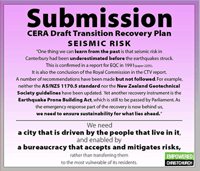
A poster created by Empowered Christchurch to advertise their submission to the CERA Draft Transition Recovery Plan on social media.The poster reads, "Submission, CERA Draft Transition Recovery Plan. Seismic Risk. One thing we can learn from the past is that seismic risk in Canterbury has been underestimated before the earthquakes struck. This is confirmed in a report for EQC in 1991 (paper 2005). It is also the conclusion of the Royal Commission in the CTV report. A number of recommendations have been made but not followed. For example, neither the AS/NZS 1170.5 standard nor the New Zealand Geotechnical Society guidelines have been updated. Yet another recovery instrument is the Earthquake Prone Building Act, which is still to be passed by Parliament. As the emergency response part of the recovery is now behind us, we need to ensure sustainability for what lies ahead. We need a city that is driven by the people that live in it, and enabled by a bureaucracy that accepts and mitigates risks, rather than transferring them to the most vulnerable residents."

A box containing drilling cores from soil sampling. The photographer comments, "These are the samples from drilling near my home. As you can see they are not so much samples as sand piles. The drill in a nearby street went down 20m and it was sand all the way. This is the box of samples from the ground level to 4.6m deep".

The seismic survey truck T-Rex (from University of Texas) was in Bexley and Pacific Park a few days ago and may have left this calling card on the front lawn of my old "red zone" house. Obviously the geotechs will know what it means.