
Photograph captioned by Fairfax, "Strategy Design building partially demolished".

Photograph captioned by Fairfax, "Closed backpackers (earthquake damaged) building".

Photograph captioned by Fairfax, "Closed backpackers (earthquake damaged) building".

Photograph captioned by Fairfax, "Closed backpackers (earthquake damaged) building".

A graphic giving the status of significant buildings in central Christchurch.

An infographic showing a possible scenario for the CTV Building collapse.

A page banner promoting an article titled, "(Re)building your future".

A map showing the locations of buildings to be demolished in the CBD.

An infographic describing problems with The Clinic, a tenant in the CTV building.

An infographic describing the collapse of the stairwell in the Forsyth Barr building.

An infographic describing the collapse of the stairwell in the Forsyth Barr building.

A graphic to accompany an article about survivors of the PGC building collapse.

An infographic to accompany an article about survivors of the PGC Building collapse.
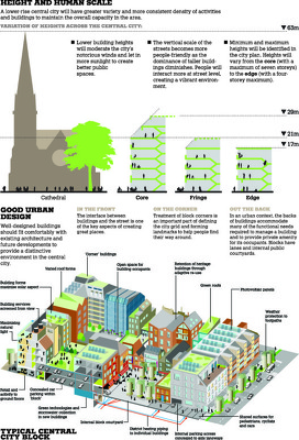
An infographic illustrating building height limits outlined in the draft Central City Plan.

A graphic showing 19th-century artifacts found during the demolition of a 1970s building.

Photograph captioned by Fairfax, "Damage to Christchurch CBD buildings after the September 4th earthquake. The MLC building on Manchester Street".

Damage to the Caxton Press building (left) and the adjoining building. In front is a pile of bricks, cordonned off with tape and road cones to keep the public away. Spray-painted codes show that the buildings have been checked by USAR.

The left-hand section of a timeline of the CTV building.

The right-hand section of a timeline of the CTV building.

A photograph captioned by BeckerFraserPhotos, "Rubble in front of the Press Building in Cathedral Square".

A photograph captioned by BeckerFraserPhotos, "Rubble in front of the Press Building in Cathedral Square".

A photograph captioned by BeckerFraserPhotos, "Rubble in front of the Press Building in Cathedral Square".

An infographic explaining a possible scenario for the collapse of CTV building.

A map showing the location of major building consents issued in Christchurch.

An infographic giving statistics about building remediations at the University of Canterbury.
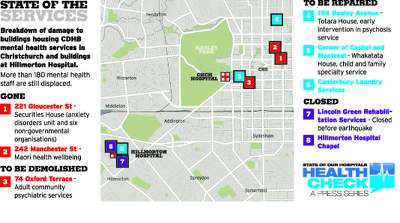
An infographic giving the status of Canterbury District Health Board mental health service buildings.

Photograph captioned by Fairfax, "Building being demolished following Canterbury's earthquakes".

Photograph captioned by Fairfax, "Damage to building in central Christchurch".

A photograph of a vacant site on Press Lane next to the Press building. The site is to be the location of Atmosphere, a large-scale installation which is part of LUXCITY.

Martin van Beynen, a reporter for The Press newspaper, photographing damage to Wave House (Winnie Bagoes Pizza Bar). Masonry from the building has collapsed onto several parked cars.