
Search
found 211 results
Twelve Days of Christmas (part 2)
Images, eqnz.chch.2010
20131228_6787_1D3-82 Twelve Days of Christmas (part 2) The NG building on Madras Street was given the go ahead to repair earthquake damage, which the owners did at some expense, Now, the government want this land to build a central city stadium, so there is a protest on the windows set to the Christmas song the Twelve Days of Christmas. 12 mi...

The old Odeon Theatre
Images, eqnz.chch.2010
20131228_6797_1D3-58 The old Odeon Theatre The back of the old Odeon movie theatre, that was for about 15-20 years a New Life Christian Centre. This is earthquake damage, although the roof was lifted off in 2011. I don't know whether this is a building that they want to save or still awaiting demolition. The smaller building to the immediate...
20120321_2397_1D3-47 Beachcomber Dairy
Images, eqnz.chch.2010
20120321_2397_1D3-47 Beachcomber Dairy Corner of New Brighton Road and Rawson Street, New Brighton. This diary is inside the suburban red zone and will probably be demolished some time in the future. See how the earthquakes have moved the footpath - the post and phone box used to stand straight! This is one of the Teleccom Wi-Fi hotspot boo...

20130627_8878_1D3-28 We need the Pot of Gold!!
Images, eqnz.chch.2010
On the day the the government and council jointly announced who will fund what, for the Christchurch rebuild, a rainbow appears over the rebuild of the Latimer Hotel. For the central city the figures are: NZ$4.9 billion with $2.9 billion coming from central government and $1.9 billion coming from the local city council (us ratepayers in Christc...

20111229_7210_1D3-195 Bexley Wetlands and Pacific Park
Images, eqnz.chch.2010
The flooded Bexley Wetlands, now about 1 - 1.5metre below pre earthquake level. The short length of fence (mid ground) was on the "river track" that the council closed about three years ago. The whole track in this view is now under about 500mm water at high tide. The main track in front of the houses was, prior to earthquakes, below the leve...

20130627_8864_1D3-32 Pay Here
Images, eqnz.chch.2010
Maybe it should be titled "Pray Here"! The old church buildings next to the Christchurch Basilica (Cathedral of the Blessed Sacrament) have been demolished and replaced with ANOTHER Wilson's Car Park. Hundreds of sites in the city where buildings have been demolished after the earthquakes have been replaced in the short term by car parks!

20130524_7214_1D3-40 Hidden park bench
Images, eqnz.chch.2010
Prior to the earthquakes (mainly the February 22 2011 event) this park bench was at track level. Shortly after the February quake someone in the council did the sums and realised that the area near the Avon River had dropped between a metre and 1.4m (about 4 foot), so a rush job by contractors shifted in many tonnes of rock and gravel to raise a...

20131212_6234_1D3-24 Another New Brighton building comes down (Day 346/365)
Images, eqnz.chch.2010
20131212_6234_1D3-24 Another New Brighton building comes down (Day 346/365) The old Esplanade Tavern is being demolished due to damage suffered in the earthquakes of 2011. Another one of New Brighton's iconic buildings to go. #4457

19 Velsheda Street
Images, eqnz.chch.2010
20130613_7580_1D3-24 19 Velsheda Street The two nice trees in the front of my old property on the right (now owned by the government) have been cut down so the main section of the house behind could be trucked down the drive. The truck must have been up against the fence to get the height above the house to the left (15 Velsheda Street). Down t...

20140112_7560_1D3-32 Graffiti book is open (SH 52)
Images, eqnz.chch.2010
Scavenger Hunt 101 - SH 52 (graffiti) Graffiti (or wall art) on the now visible side of a building in central Christchurch. There are still about 100 major buildings to be demolished in the city post the earthquakes.

20140110_7484_1D3-40 Avon River and earthquake damage
Images, eqnz.chch.2010
Low tide on the Avon River at New Brighton/Bexley. Note the original bank and the rock wall slipage on right. The white additions were added in March and April 2011 to protect the properties behind from flooding. Ultimately this area was "red zoned" with all houses removed or to be removed and the ground left till a rehabilitation method can ...

20130901_2869_1D3-150 Wilson City!
Images, eqnz.chch.2010
As buildings are demolished as a result of the earthquake in 2011, Wilson Carparking are waiting to pounce on each bit of vacant land. Someone suggested about a year ago that the city be renamed "Wilson" as that name appears more in the central city than Christchurch does! In the background the CERES NZ nibbler attacks the support structure fo...

It has started!
Images, eqnz.chch.2010
20140521_1080_1D3-24 It has started! Removal of the double-glazed windows is underway at my "red zone" house, now owned by the Government of New Zealand. Sold to CERA (the government agency) in October 2012 and has remained empty since, despite having little damage, apart from the tilt to the front from the land damage that occurred during the...

A throne for a King? [Explored]
Images, eqnz.chch.2010
20140713_1530_1D3-40 A throne for a King? [Explored] Another house has gone from Seabreeze Close, Pacific Park, Bexley, leaving just the concrete base, a few floor tiles and the smashed toilet (throne). Houses are being demolished (85%) or deconstructed/shifted (15%) as a result of land damage in the major earthquakes of 4th September 2010, ...

20140927_2219_1D3-24 Planting natives at Harold Henry Park
Images, eqnz.chch.2010
20140927_2219_1D3-24 Planting natives at Harold Henry Park A planting of native bushes and trees in the old children's playground area in Bexley, Organised by the Facebook group Avon River Park and assisted by ex Bexley residents. This is right in the middle of the Bexley red zone with most houses removed or demolished now. #5832

20141005_2502_1D3-40 CTV site
Images, eqnz.chch.2010
The sign reads: The CTV Building was headquarters of Canterbury Television (CTV) and also housed King’s Education language School, a medical clinic, Hair Consultants, Relationship Services and a nursing school. On February 22nd 2011 the building collapsed as a result of a major earthquake. Sadly, 115 people who were in the building lost their l...

Red Zone Closures
Images, eqnz.chch.2010
20160415_0029_1D3-24 Red Zone Closures The permanent closure (to motor vehicles) of the Bexley red zone streets has started. This was once the main south-north route just west of the Avon River in the New Brighton area, till an expressway (ring road) was built about 80m to the west (right) about 12-13 years ago. Then it became just another ...

The Wobbly Jetty - 1 (106/366) [Explored]
Images, eqnz.chch.2010
20160415_0039_1D3-40 The Wobbly Jetty - 1 (106/366) [Explored] The South New Brighton jetty was rebuilt a couple of years before the 2010 and 2011 earthquakes wrecked it. Then, it was straight, level and all railings on left side were intact. Was closed to the public for about four years but is open now. #7221

20160612_8429_1D3-40 Abandoned and maybe forgotten
Images, eqnz.chch.2010
AMI Stadium (Lancaster Park), not used since the February 2011 earthquake. It was used predominantly for rugby and cricket. We are still waiting to see what the outcome is for this stadium. Government want a new one closer to the CBD, so there is talk of this being demolished, while others want it repaired. The concrete pad lower left is ...

Trees in the Red Zone (307/365)
Images, eqnz.chch.2010
20171103_5582_1D3-38 Trees in the Red Zone (307/365) In what used to be sections with houses and yards. Between late 2011 and 2014 the houses (well 95% of them) were removed due to land dropping in the 2011 earthquakes and the proximity of the Avon River, tidal in this area. #8859

Where once stood houses (Day 348/365)
Images, eqnz.chch.2010
20131214_6268_1D3-24 Where once stood houses (Day 348/365) The area beside the lower Avon River in New Brighton of Evans Avenue and Admirals Way has been cleared of houses and boundary fences (there were between 15 and 20 houses on this block) , fully fenced with post and wire and "spray on" grass applied. These were all red zone properties a...

Twelve Days of Christmas (part 1)
Images, eqnz.chch.2010
20131228_6786_1D3-97 Twelve Days of Christmas (part 1) The NG building on Madras Street was given the go ahead to repair earthquake damage, which the owners did at some expense, Now, the government want this land to build a central city stadium, so there is a protest on the windows set to the Christmas song the Twelve Days of Christmas. 12 mi...

My trees have gone!
Images, eqnz.chch.2010
20130613_7577_1D3-24 My Trees cut down so a house being removed from behind could get out above the fence on one of those elevating house removal trailers. I don't know the story about the yellow (recycling) wheelie bin - the wheels have been removed. This was my house from March 2004 to mid-2012 when it was purchased by the government as it s...

20130826_2587_1D3-28 Here we go again! (Day 238/365)
Images, eqnz.chch.2010
Only it is worse this time! As from Wednesday I won't have car access to the property, nor the street, nor one of the neighbouring streets - for a month at least! A second attempt to do a sewer repair after the earthquakes - yes I know they were 3 to 2½ years ago!

20130125_1749_1D3-400 Road Closed 1
Images, eqnz.chch.2010
20130125_1749_1D3-400 Road Closed 1 The Lyttelton side of Evans Pass is closed (since the earthquake 23 months ago - 22/02/11). Prior to the road tunnel (through the Port Hills) opening in the early 1960s this was the main access road to the port of Lyttelton. #3072

20160307_0012_1D3-32 Subway is closed (067/366)
Images, eqnz.chch.2010
20160307_0012_1D3-32 Subway is closed (067/366) The Subway shop in the High Street Mall has not operated since lunch time on the 22nd February 2011 when the most damaging of Christchurch and Canterbury's earthquakes struck. I assume the building is still to be demolished. #7119
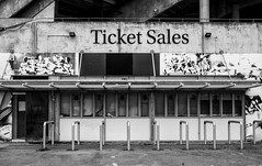
20160612_8434_1D3-40 Ticket Sales (164/366)
Images, eqnz.chch.2010
The ticket office at Lancaster Park (AMI Stadium), not used since the February 2011 earthquake. Windows broken and door boarded up. We are still waiting to see what the outcome is for this stadium. Government want a new one closer to the CBD, so there is talk of this being demolished, while others want it repaired.

20130622_7842_1D3-24 Disabled in more ways than one (Day 173/365)
Images, eqnz.chch.2010
One of many disabled carparks outside what used to be one of the great sporting complexes in New Zealand. The Queen Elizabeth II Park complex in north-east Christchurch was built initially for the 1974 Commonwealth Games and was used for track and field and the adjoining pool complex had swimming and diving. It was built on an area that was used...

20130630_9138_1D3-58 IRD Building (Day 181/365)
Images, eqnz.chch.2010
The old (or is that the new) Inland Revenue Department (IRD) building on the corner of Madras and Cashel Streets in central Christchurch. Built in 2006/07 on the site of the former Farmers department store (itself badly damaged by fire), it was just a few years old when the earthquake of February 2011 struck, and subsequent quakes (all through 2...

Waters Edge Demolition [Explored]
Images, eqnz.chch.2010
20120529_5558_1D3-400 Waters Edge Demolition [Explored] Demolition of the relatively new seven-storey Waters Edge Apartments in Ferrymead continues. CERES Environmental NZ are doing the job for CERA (Canterbury Earthquake Recovery Authority). Some will be pleased to see this block go as there was lot of resentment to it being built on the site...