Search
found 422 results
BeckerFraserPhotos February 2011 photograph 397
Images, UC QuakeStudies
A view across the Avon River from Avonside Drive to a Port-a-loo that has been set up for residents without functioning sewers as a result of the 4 September 2010 earthquake.
BeckerFraserPhotos February 2011 photograph 333
Images, UC QuakeStudies
A large crack in the ground at Sullivan Park in Avonside which has resulted from the 4 September 2010 earthquake. Remnants of liquefaction silt can be seen around the edges of the crack.
BeckerFraserPhotos February 2011 photograph 328
Images, UC QuakeStudies
A large crack in the ground at Sullivan Park in Avonside which has resulted from the 4 September 2010 earthquake. Remnants of liquefaction silt can be seen around the edges of the crack.
BeckerFraserPhotos February 2011 photograph 330
Images, UC QuakeStudies
A large crack in the ground at Sullivan Park in Avonside which has resulted from the 4 September 2010 earthquake. Remnants of liquefaction silt can be seen around the edges of the crack.
BeckerFraserPhotos February 2011 photograph 280
Images, UC QuakeStudies
A sign attached to a power pole on Avonside Drive reading, "Low power lines". The footpath around it has cracked and sunk in places as a result of the 4 September 2010 earthquake.
BeckerFraserPhotos February 2011 photograph 332
Images, UC QuakeStudies
A large crack in the ground at Sullivan Park in Avonside which has resulted from the 4 September 2010 earthquake. Remnants of liquefaction silt can be seen around the edges of the crack.

Certificate: The Press Champion Canterbury Supreme Award
Images, Canterbury Museum
One framed certificate issued to SCIRT in 2013 to mark winning The Press Champion Canterbury Supreme Award in the Medium-Large Enterprise category.
BeckerFraserPhotos February 2011 photograph 223
Images, UC QuakeStudies
A view of the Medway Street footbridge through a safety fence that is blocking access to it. The bridge links Avonside Drive and River Road. It was damaged in the 4 September 2010 earthquake.
BeckerFraserPhotos February 2011 photograph 318
Images, UC QuakeStudies
A view down Galbraith Avenue in Avonside. The footpath and road have been cracked by the 4 September 2010 earthquake. Small deposits of dry liquefaction silt can be seen on patches of the road.
BeckerFraserPhotos February 2011 photograph 268
Images, UC QuakeStudies
A view down Bracken Street in Avonside. A power pole has been propped up by a concrete block because the asphalt around it has sunk as a result of the 4 September 2010 earthquake.
BeckerFraserPhotos February 2011 photograph 362
Images, UC QuakeStudies
The fence of a house on Robson Avenue in Avonside. Part of the breeze-block section at its base has collapsed in the 4 September 2010 earthquake, leaving only the timber part above it.
BeckerFraserPhotos February 2011 photograph 319
Images, UC QuakeStudies
A view down Galbraith Avenue in Avonside. The footpath and road have been cracked by the 4 September 2010 earthquake. Small deposits of dry liquefaction silt can be seen on patches of the road.
BeckerFraserPhotos February 2011 photograph 398
Images, UC QuakeStudies
A worker poses with the truck he has been using to drain the septic tanks installed in front of Avonside properties to allow residents to use their toilets after the 4 September 2010 earthquake.
BeckerFraserPhotos June 2011 photograph 208
Images, UC QuakeStudies
Photograph captioned by BeckerFraserPhotos, "Arts Centre. The plywood on the top of the gable was placed there after the 4 September 2010 earthquake but the bricks below collapsed during the 22 February 2011 earthquake.

Digital Photograph: Former Convent of Our Lady of Mercy, Exeter Street, Ly…
Images, Canterbury Museum
One landscape colour digital photograph taken on 25 September 2011 showing the remaining portion of the former Convent of Our Lady of Mercy. St Mary's School, run by the Sisters of Mercy, was also housed in this building. At the time of the 4 September 2010 earthquake the building was a private residence. The picture shows the perimeter wall, t...

Digital Photograph: Site of the Harbourlight Theatre, London Street, Lytte…
Images, Canterbury Museum
One landscape colour digital photograph taken on 14 September 2012 showing the site of the Harbourlight Theatre on London Street. The retaining wall at the rear of the site collapsed and part of the adjoining land eroded. Also visible in the photograph are the side walls of the Bank of New Zealand and the former Westpac Branch, now Himalaya Desi...

Digital Photograph: Partially Demolished Shops, corner of London and Oxfor…
Images, Canterbury Museum
One landscape colour digital photograph taken on 14 September 2012 showing a block of partially demolished shops on the corner of London and Oxford Streets. The businesses (from left to right) are Bells Pharmacy, Leslie's Bookshop and Lyttelton Sea Foods. The site of The Empire Hotel is visible to the right of the photograph. By the time this p...

Digital Photograph: Godley Head Lighthouse
Images, Canterbury Museum
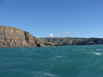
One landscape colour digital photograph taken on 26 May 2013 showing the Godley Head Lighthouse and cliffs. Taken from the entrance to Lyttelton Harbour looking north. The Godley Head Lighthouse (K4286) was discontinued on 6 July 2012. Volcanic banding is visible in the face of the cliffs. There were several major rock falls along the coastal ...

Digital Photograph: Earthquake damage to searchlight emplacements, Godley …
Images, Canterbury Museum
One landscape colour digital photograph taken on 26 May 2013 showing the southern cliffs of Godley Head. Taken from the middle of the shipping channel. Some earthquake damage to the cliffs is visible. There were several major rock falls along the coastal cliffs near Christchurch and Lyttelton Harbour. At Godley Head these caused damage to the W...

Digital Photograph: Godley Head
Images, Canterbury Museum
One landscape colour digital photograph taken on 26 May 2013 showing the southern cliffs of Godley Head, taken from the middle of the shipping channel. Some earthquake damage to the cliffs is visible. There were several major rock falls along the coastal cliffs near Christchurch and Lyttelton Harbour. At Godley Head these caused damage to the ...

Digital Photograph: London and Oxford Streets
Images, Canterbury Museum
One landscape colour digital photograph taken on 27 May 2013 of London Street in Lyttelton. Taken from Sumner Road looking west across the intersection of London and Oxford Streets. The photograph shows several empty sections and the remaining buildings. The Lyttelton streetscape has changed dramatically from its pre-earthquake appearance and w...

Digital Photograph: Site of Church of the Most Holy Trinity, Lyttelton
Images, Canterbury Museum
One landscape colour digital photograph taken on 26 May 2013 on Winchester Street, Lyttelton. The photograph is taken looking southeast over the site of the Anglican Church of the Most Holy Trinity. On the church site are the removed top of the bell tower and porch. Beyond the empty church site the container cranes on Cashin Quay, and Diamond Ha...

Digital Photograph: Godley Head
Images, Canterbury Museum
One landscape colour digital photograph taken on 26 May 2013 off Godley Head looking west towards the face of the cliffs. Rock which fell from the cliffs is heaped at the waters edge. Some of the buildings from the coastal defence battery are visible on top of the cliff. Volcanic banding is visible in the face of the cliffs. There were severa...

Digital Photograph: Retaining Wall, Sumner Road, Lyttelton
Images, Canterbury Museum
One landscape colour digital photograph taken on 27 May 2013 of a retaining wall in Sumner Road which was replaced due to earthquake damage. The original wall was created using red volcanic rock. Many walls like this were built using the Hard Labour Gang from the Lyttelton Gaol. The replacement wall has a small section of stone installed to sho...

Digital Photograph: Elevated view of London Street, Lyttelton
Images, Canterbury Museum
One landscape colour digital photograph taken on 26 May 2013 of London Street, Lyttelton. The photograph was taken from St Davids Street looking west. The roofs of the portable buildings forming the temporary Lyttelton Police station are visible in the foreground. The Lyttelton Port Company offices and Tunnel Portal are prominent in the midgrou...

Digital Photograph: Retaining Wall, Sumner Road, Lyttelton
Images, Canterbury Museum
One landscape colour digital photograph taken on 27 May 2013 of a retaining wall in Sumner Road which was replaced due to earthquake damage. The original wall was created using red volcanic rock. Many walls like this were built using the Hard Labour Gang from the Lyttelton Gaol. The replacement wall has a small section of stone installed to sho...

Digital Photograph: Sticker on Car Windscreen
Images, Canterbury Museum
One landscape colour digital photograph taken on 26 May 2013 on Winchester Street, Lyttelton. The photograph shows part of the rear windscreen of a blue car with a sticker which reads 'I don't need sex EQC is screwing me'. The right side of the sticker is torn leaving a jagged edge. The process of negotiation with EQC and insurance companies to...

Digital Photograph: Norwich Quay, Lyttelton.
Images, Canterbury Museum
One landscape colour digital photograph taken on 26 May 2013 on the corner of Norwich Quay and Canterbury Street, Lyttelton. The photograph shows the sites of the Royal Hotel, Shadbolt House, and the Lyttelton Hotel along Norwich Quay. The Wunderbar and the repair and strengthening work underway on the Lyttelton Working Mens Club/The Loons are v...
Digital Photograph: Godley Head, Lyttelton Harbour
Images, Canterbury Museum
One landscape colour digital photograph taken on 26 May 2013 off Godley Head looking north to Boulder Bay and Taylors Mistake. Rock which fell from the cliffs is heaped at the waters edge. Volcanic banding is visible in the face of the cliffs. There were several major rock falls along the coastal cliffs near Christchurch and Lyttelton Harbour....

Digital Photograph: Winchester Street, Lyttelton
Images, Canterbury Museum
One landscape colour digital photograph taken on 26 May 2013 on Winchester Street, Lyttelton. The photograph is taken looking south from the site of the Catholic Church of St Joseph the Worker to the site of the Anglican Church of the Most Holy Trinity. Visible are the removed top of the bell tower and porch. The damaged vicarage is at the weste...