
Graphs illustrating the results of a survey of Christchurch residents.

A map showing the location of buildings given urgent status by CERA.

A graph showing the University of Canterbury's projected operating deficit.
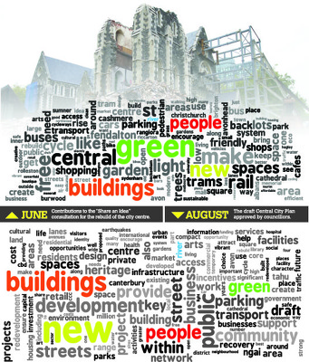
Word clouds comparing the draft Central City Plan to Share an Idea contributions.

A page banner promoting a feature on aerial photographs of Christchurch.

A map showing residential property developments in Canterbury.

A map showing the proposed location for a red-light district.

A page banner promoting earthquake-related articles.

A page banner promoting articles about the Christchurch rebuild.

A map showing newly Green-Zoned properties in the Port Hills.

A compliation of front pages of newspapers featuring Budget stories.

A graphic for a feature titled, "The hard yards".

A list of newly released casualities of the 22 February 2011 earthquake.

An incomplete graphic showing zones of damage in Brooklands, Spencerville, and Pines and Kairaki Beach.

An infographic comparing statements by Mayor Bob Parker and Sir Bob Jones.
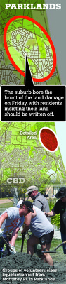
An infographic about land damage in Parklands.

A map showing the changes to electorate enrolments.

A map showing the possible location of a fault line below Christchurch.

An uncompleted map showing the location and status of supermarkets.

A map showing the route of the Red Zone bus tour.

Digitally manipulated image of the damaged Cathedral of the Blessed Sacrament, superimposed with a seismograph trace. The photographer comments, "What we want to forget, but must remember".

Graffiti on a wooden wall depicts a child pointing at a site across the street and reads "I remember when the Kazbah was over there." The photographer comments, "A local street artist has commemorated Christchurch's deadliest earthquake. The anniversary is tomorrow. Where the photograph was taken was the site of the Ozone Hotel, which has now gone as well. For some of us who live and work in the East of Christchurch the earthquake was not what happened in the City as we were almost unaware of it. We had no water, toilets and most of all no electricity for weeks. For myself petrol was low and with tales of all the petrol stations on our side of town being damaged we could not take the chance of venturing out on severely damaged roads to find no petrol and the possibility of not getting home. We walked around and saw the damage that was local to us. TJ's Kazbah was one that stood out. A building that had a beauty with its round tower standing proud and always looked well kept - it was now collapsed. Its tower, which was once pointing towards the sky was laying on its side. It had kept its shape, but had a lightning shaped crack through it. The one thing that kept us feeling almost normal through the coming weeks was The Press our daily paper still being delivered even though the Press building and staff had suffered so badly themselves.

A page banner promoting an article titled, "Message in a bottle".

A graphic describing the status of heritage buildings.

A page banner advertising a 'Project Canterbury' feature.

A map showing the location and magnitude of an aftershock 10km east of Lyttelton.

A page banner promoting a feature about lessons to be learnt from San Francisco.

A graph showing annual house value growth in Canterbury.

A page banner promoting an article titled, "Leaving town".

An infographic showing the location of malls built from shipping containers.