
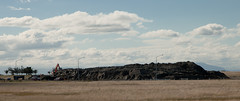
According to the sign it can take about 30 minutes to walk from the entry point (near the small statue) to the centre and out again. What you can do with a few thousand old bricks and gravel. See next photo for more detail.

The small wharf area of the now gone Pleasant Point Yacht Club has already been taken over by the Pied Shags (cormorants).
It is under water now except for low tide. Note the dead pine tree in background. Many have died because of the salt water their roots are in.

According to the sign it can take about 30 minutes to walk from the entry point (here) to the centre and out again. That is without stepping across the gaps between bricks. What you can do with a few thousand old bricks and gravel!

Cleaning up Manning Signs of the silt from liquefaction. Three fellow workers man the shovels while two building engineers talk to the boss (hidden). After doing the car park we then turned our hands to the inside of the factory, once clearance was given that we could go inside.

20130211_2645_1D3-840 South New Brighton bridge damage (under repair)
Earthquake damage (that right hand abutment should be vertical with the bridge and the hand rail level). Bridge is closed to eastbound traffic (to left) and has a 3500kg weight limit as well.
The eastern approach is the same. Damage caused mainly in the 04/09/10 and 22/02/11...
This is a temporary pile of silt piled on the old Bexley landfill sight. Some trucks are addng to the pile, while other truck and trailer units are taking it away to the old Bottle Lake landfill sight, a few km to the north of here.

20131212_6234_1D3-24 Another New Brighton building comes down (Day 346/365)
The old Esplanade Tavern is being demolished due to damage suffered in the earthquakes of 2011. Another one of New Brighton's iconic buildings to go.
#4457

The flooded Bexley Wetlands, now about 1 - 1.5metre below pre earthquake level. The short length of fence (mid ground) was on the "river track" that the council closed about three years ago. The whole track in this view is now under about 500mm water at high tide.
The main track in front of the houses was, prior to earthquakes, below the leve...

20130613_7580_1D3-24 19 Velsheda Street
The two nice trees in the front of my old property on the right (now owned by the government) have been cut down so the main section of the house behind could be trucked down the drive. The truck must have been up against the fence to get the height above the house to the left (15 Velsheda Street). Down t...

20131214_6268_1D3-24 Where once stood houses (Day 348/365)
The area beside the lower Avon River in New Brighton of Evans Avenue and Admirals Way has been cleared of houses and boundary fences (there were between 15 and 20 houses on this block) , fully fenced with post and wire and "spray on" grass applied.
These were all red zone properties a...

20160307_0012_1D3-32 Subway is closed (067/366)
The Subway shop in the High Street Mall has not operated since lunch time on the 22nd February 2011 when the most damaging of Christchurch and Canterbury's earthquakes struck. I assume the building is still to be demolished.
#7119

Work is continuing on the earthquake damaged South New Brighton bridge. Avon River to the left, Avon-Heathcote Estuary the other side of the bridge.

The damaged (and once iconic Christchurch Cathedral) waits it's fate (repaired or demolish/rebuild) with the Millenium hotel in background.

Maybe it should be titled "Pray Here"!
The old church buildings next to the Christchurch Basilica (Cathedral of the Blessed Sacrament) have been demolished and replaced with ANOTHER Wilson's Car Park. Hundreds of sites in the city where buildings have been demolished after the earthquakes have been replaced in the short term by car parks!

As buildings are demolished as a result of the earthquake in 2011, Wilson Carparking are waiting to pounce on each bit of vacant land. Someone suggested about a year ago that the city be renamed "Wilson" as that name appears more in the central city than Christchurch does!
In the background the CERES NZ nibbler attacks the support structure fo...

Deconstruction has been halted, but this was the front of Christchurch's most famous landmark. The tower/spire was above the nearest bit of remains.

The jetty in the South New Brighton Domain was rebuilt a few years ago. It was straight and level till the earthquakes. Has been closed for 2½ years now.

Shot from up Hunstbury Hill with a 600mm f/4 on a very grey morning. 8am demolition. The guy behind me only looked up when the sounds of the explosion reahed us and the building was half way down!

Houses teeter over the edge above Redcliffs School.

20120131_8174_1D3-400 Eathquake damage
Houses above Main Road, Sumner.
#2153

Damaged houses above Shag Rock.
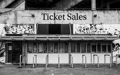
The ticket office at Lancaster Park (AMI Stadium), not used since the February 2011 earthquake. Windows broken and door boarded up.
We are still waiting to see what the outcome is for this stadium. Government want a new one closer to the CBD, so there is talk of this being demolished, while others want it repaired.

20130613_7577_1D3-24 My
Trees cut down so a house being removed from behind could get out above the fence on one of those elevating house removal trailers. I don't know the story about the yellow (recycling) wheelie bin - the wheels have been removed.
This was my house from March 2004 to mid-2012 when it was purchased by the government as it s...
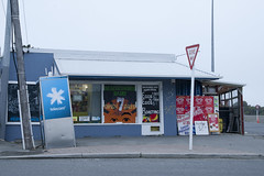
20120321_2397_1D3-47 Beachcomber Dairy
Corner of New Brighton Road and Rawson Street, New Brighton. This diary is inside the suburban red zone and will probably be demolished some time in the future. See how the earthquakes have moved the footpath - the post and phone box used to stand straight! This is one of the Teleccom Wi-Fi hotspot boo...

Part of a house that fell can be seen on the rocks above right hand containers.

Part of the container wall to stop rock falls on Main Road, Sumner.
The jetty in the South New Brighton Domain was rebuilt a few years ago. It was straight and level till the earthquakes. Has been closed for 2½ years now.

The jetty in the South New Brighton Domain was rebuilt a few years ago. It was straight and level till the earthquakes. Has been closed for 2½ years now. The shags like it though!

The electrical supply substation built into the Lion Breweries Canterbury Draught brewery in St Asaph Street, Christchurch. Now the whole complex is being demolished due to earthquake damage.

The sea wall at Beachville Road, Redcliffs, after the earthquake. It used to be straight and level - not now!
As a teenager I went fishing off this wall.