
Search
found 264 results
20130814_2441_1D3-58 Cranes (Day 226/365)
Images, eqnz.chch.2010
Work is continuing on the earthquake damaged South New Brighton bridge. Avon River to the left, Avon-Heathcote Estuary the other side of the bridge.

20130123_1662_1D3-35 Canterbury substation (Day 23/365)
Images, eqnz.chch.2010
The electrical supply substation built into the Lion Breweries Canterbury Draught brewery in St Asaph Street, Christchurch. Now the whole complex is being demolished due to earthquake damage.

20160307_6607_7D2-110 Interior removal
Images, eqnz.chch.2010
The Forsyth Barr building has stood silent and empty (except the occasional intruder and pigeons) since the February 2011 earthquake. It was sold "as is" and I understand that it is now going to be fitted out as a hotel. This is the building that had severe stairwell damage during the quake necessitating people being lowered via ropes etc on t...
20110307_2009_1D3-85 Liquefaction silt pile [EQNZ]
Images, eqnz.chch.2010
This is a temporary pile of silt piled on the old Bexley landfill sight. Some trucks are addng to the pile, while other truck and trailer units are taking it away to the old Bottle Lake landfill sight, a few km to the north of here.

20110228_1595_1D3-24 The Clean Up [EQNZ]
Images, eqnz.chch.2010
Cleaning up Manning Signs of the silt from liquefaction. Three fellow workers man the shovels while two building engineers talk to the boss (hidden). After doing the car park we then turned our hands to the inside of the factory, once clearance was given that we could go inside.

Warning (Day 220/365)
Images, eqnz.chch.2010
20130808_2300_1D3-40 Warning (Day 220/365) Across the river were a row of several houses - all gone now. That side of the river is "Red Zone" and will be devoid of houses soon. #4077

20130125_1760_1D3-115 Road Closed 2
Images, eqnz.chch.2010
This is the Summit Road below Mt Cavendish and shows a few remaining high buildings in the central city beyond (in setting sun). Just above centre is the doomed AMI Stadium (1) aka Lancaster Park, home to Canterbury cricket and rugby till the erathquakes.

South New Brighton boardwalk track [Explored]
Images, eqnz.chch.2010
20130312_4425_1D3-150 South New Brighton boardwalk track [Explored] Damaged in the earthquakes, now with more bends and not level as it was before. Selected for Explore. #306 12/05/13 #3402

Bridge Street split depth - Christchurch earthquake
Images, eqnz.chch.2010
20100905_3347_1D3-32 Bridge Street split depth - Christchurch earthquake The city side of the South Brighton bridge. Approaches on both sides will need extensive work before this bridge can re-open. Bridge opened for traffic less than a week later, but still (23/09) has 30kmh speed restriction. #378

Six years on
Images, eqnz.chch.2010
20161211_0216_1D3-24 Six years on A view that was impossible six years ago. There was a group of buildings including another high-rise in the vacant area in the middle ground. #7986

20130315_0989_EOS M-46 Closed for refurbishment? Building demolished (Day …
Images, eqnz.chch.2010
Strange sign when the building it refers to is no longer there. Earthquake damage.

Another one on the way out!
Images, eqnz.chch.2010
20130704_7680_EOS M-22 Another one on the way out! The Mack tractor unit with "half a house" ready to depart in the middle of the night, when the roads are quiet. But where is this house heading too? #3900

20130107_2541_G12-08 Sloping (007/365)
Images, eqnz.chch.2010
35 Hargood Street, Woolston - earthquake land damage. Second house away from the Woolston Club.

20130901_2890_1D3-70 10:26am Gone!
Images, eqnz.chch.2010
See previous photo (exactly 3 hours earlier). Demolition of the support structure for NZ Breweries smokestack in Christchurch. CERES NZ's nibbler is at work, the pipe stack having been removed yesterday (Saturday). This is three hours after the previous photo, and just a pile of rubble sits beside the tree (largely undamaged despite being next...

20130901_2862_1D3-175 7:26am
Images, eqnz.chch.2010
Demolition of the support structure for NZ Breweries smokestack in Christchurch. CERES NZ's nibbler is at work, the pipe stack having been removed yesterday (Saturday). I retuned three hours later to see what progress had been made and it was GONE! See next photo. Damage to complex was from the 22/02/20011 earthquake.

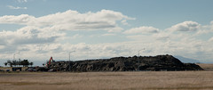
20130207_2231_1D3-165 Sumner and "container alley"
Images, eqnz.chch.2010
Nearly 80 40 foot containers (most two high) protect Wakefield Avenue in Sumner from further rock falls. Behind these (to the left) are houses, church, bowling club, RSA (Returned Servicemens Association) and other community buildings that have been isolated now for nearly two years now. On the right upper third boundary (just behind two stand a...

20120129_8116_1D3-200 Pleasant Point Yacht Club
Images, eqnz.chch.2010
The small wharf area of the now gone Pleasant Point Yacht Club has already been taken over by the Pied Shags (cormorants). It is under water now except for low tide. Note the dead pine tree in background. Many have died because of the salt water their roots are in.

20111230_7222_1D3-70 New Brighton
Images, eqnz.chch.2010
20111230_7222_1D3-70 New Brighton Further damage to the bank following the two quakes on 23/12/11. The sewer line broke here and was repaired (patched) by council staff on Christmas Eve. It is hard to beleve that this rock wall was level with the land here, before any of the quakes. #2004

Christchurch earthquake
Images, eqnz.chch.2010
20100904_3309_1D3-24 Christchurch earthquake Wairoa Street Another web site used this image (with a link to this Flickr page), so the view count sky rocketed. CERA (Canterbury Earthquake Recovery Authority)/Tonkin & Taylor also used this image on page 13 of a Land Damage presentation on 23/06/11. This was also released as a PDF. A few mo...

Seabreeze Close - Christchurch earthquake
Images, eqnz.chch.2010
20100905_3357_1D3-105 Seabreeze Close - Christchurch earthquake Annette Preen's house in background. See the angle the front of house is on. This maybe a write off as it is trashed inside with liquification occurring right under the house and bursting through concrete floor. Annette was featured on TV3 news tonight. Go to TV3 website to see ne...

20130125_1749_1D3-400 Road Closed 1
Images, eqnz.chch.2010
20130125_1749_1D3-400 Road Closed 1 The Lyttelton side of Evans Pass is closed (since the earthquake 23 months ago - 22/02/11). Prior to the road tunnel (through the Port Hills) opening in the early 1960s this was the main access road to the port of Lyttelton. #3072

20120702_1387_G12-18 Another one bites the dust
Images, eqnz.chch.2010
8 Velsheda Street, Bexley, Christchurch, across the road from my house was demolished a week or so ago, just one of many demolitions of Red Zone properties at the moment. This house was about ten years old and suffered land damage during the 4th September 2010 and 22nd February 2011 earthquakes. The same fate awaits my house later in the year o...

Twelve Days of Christmas (part 2)
Images, eqnz.chch.2010
20131228_6787_1D3-82 Twelve Days of Christmas (part 2) The NG building on Madras Street was given the go ahead to repair earthquake damage, which the owners did at some expense, Now, the government want this land to build a central city stadium, so there is a protest on the windows set to the Christmas song the Twelve Days of Christmas. 12 mi...

The old Odeon Theatre
Images, eqnz.chch.2010
20131228_6797_1D3-58 The old Odeon Theatre The back of the old Odeon movie theatre, that was for about 15-20 years a New Life Christian Centre. This is earthquake damage, although the roof was lifted off in 2011. I don't know whether this is a building that they want to save or still awaiting demolition. The smaller building to the immediate...
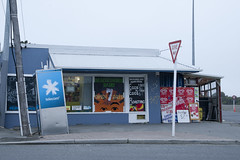
20120321_2397_1D3-47 Beachcomber Dairy
Images, eqnz.chch.2010
20120321_2397_1D3-47 Beachcomber Dairy Corner of New Brighton Road and Rawson Street, New Brighton. This diary is inside the suburban red zone and will probably be demolished some time in the future. See how the earthquakes have moved the footpath - the post and phone box used to stand straight! This is one of the Teleccom Wi-Fi hotspot boo...

20130627_8878_1D3-28 We need the Pot of Gold!!
Images, eqnz.chch.2010
On the day the the government and council jointly announced who will fund what, for the Christchurch rebuild, a rainbow appears over the rebuild of the Latimer Hotel. For the central city the figures are: NZ$4.9 billion with $2.9 billion coming from central government and $1.9 billion coming from the local city council (us ratepayers in Christc...

20130627_8864_1D3-32 Pay Here
Images, eqnz.chch.2010
Maybe it should be titled "Pray Here"! The old church buildings next to the Christchurch Basilica (Cathedral of the Blessed Sacrament) have been demolished and replaced with ANOTHER Wilson's Car Park. Hundreds of sites in the city where buildings have been demolished after the earthquakes have been replaced in the short term by car parks!

20131212_6234_1D3-24 Another New Brighton building comes down (Day 346/365)
Images, eqnz.chch.2010
20131212_6234_1D3-24 Another New Brighton building comes down (Day 346/365) The old Esplanade Tavern is being demolished due to damage suffered in the earthquakes of 2011. Another one of New Brighton's iconic buildings to go. #4457

19 Velsheda Street
Images, eqnz.chch.2010
20130613_7580_1D3-24 19 Velsheda Street The two nice trees in the front of my old property on the right (now owned by the government) have been cut down so the main section of the house behind could be trucked down the drive. The truck must have been up against the fence to get the height above the house to the left (15 Velsheda Street). Down t...

It has started!
Images, eqnz.chch.2010
20140521_1080_1D3-24 It has started! Removal of the double-glazed windows is underway at my "red zone" house, now owned by the Government of New Zealand. Sold to CERA (the government agency) in October 2012 and has remained empty since, despite having little damage, apart from the tilt to the front from the land damage that occurred during the...