Search
found 19779 results
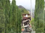
Mark Lincoln Photograph 021
Images, UC QuakeStudies
A police officer talks to the driver of a NZ Post truck at a cordon across Tuam Street. Military personnel stand nearby. The photographer comments, "this was taken shortly after the 4th September earthquake. Police allowed us free access past the cordon and simply advised us to watch out for falling masonry. The access situation was much different after the February aftershock".
Christchurch Press Image: Iain McGregor 2010:09:06 00:24:54
Images, UC QuakeStudies
Photograph captioned by Fairfax, "Major earthquake hits Christchurch. Maling Street in Avonside. From left: Ngarita Briggs (8), Walton Briggs and Paula Grant sit under a makeshift shelter while they wait for a wood fire to boil water. They are too scared to go in the house so are sleeping on the lawn".
Digital Photograph: Earthquake damage to the old Vicarage, Lyttelton
Images, Canterbury Museum
One landscape colour digital photograph taken on 25 February 2011 showing the damage to the former Anglican Vicarage on Ripon Street Lyttelton. Taken from the footpath. Architect The sense of loss felt when confronted with the collapse or demolition of an historic building is compounded when that building is also a home. While the community sees...
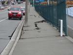
Digital Photograph: Earthquake Damage to Road on Norwich Quay, Lyttelton
Images, Canterbury Museum
One landscape colour digital photograph taken on 25 February 2011 showing earthquake damage to the road, footpath and retaining wall on Norwich Quay. The photograph is taken from below the intersection of Norwich Quay and Canterbury Street looking east along Norwich Quay. Unlike most areas of Christchurch, land damage on the Port Hills was due ...

Digital Photograph: Plume of Water from a Broken Water Main, Lyttelton
Images, Canterbury Museum
One landscape colour digital photograph taken on 28 February 2011 showing the plume of water from a broken water main. The plume appears to be in the vicinity of the Bridle Path. Photograph taken looking west from the corner of Canterbury and Ripon Streets. Repairing infrastructure following the Canterbury Earthquakes has proved to be a complex...

Digital Photograph: Lyttelton Main School from the Gaol Steps, Lyttelton
Images, Canterbury Museum
One landscape colour digital photograph taken on 13 May 2011 showing Lyttelton Main School viewed from above near the top of the Gaol Steps between Oxford and St Davids Streets. The photograph is taken at an angle. Several subsequently demolished buildings are visible beyond the school including (from left to right) Lyttelton Police Station, th...

Canterbury Earthquake 2011
Images, eqnz.chch.2010
Our Street - Cleaning Up (02.03.2011) Woolston Christchurch Canterbury New Zealand © 2011 Phil Le Cren Photo Taken With: Canon EOS 1000D + Canon EF/EF-S lenses + 10.1 effective megapixels + 2.5-inch TFT color LCD monitor + Eye-level pentamirror SLR + Live View shooting. + EOS Built-in Sensor cleaning system + Wide-a...

Canterbury Earthquake 2011
Images, eqnz.chch.2010
Our Street - Cleaning Up (03.03.2011) Woolston Christchurch Canterbury New Zealand © 2011 Phil Le Cren Photo Taken With: Canon EOS 1000D + Canon EF/EF-S lenses + 10.1 effective megapixels + 2.5-inch TFT color LCD monitor + Eye-level pentamirror SLR + Live View shooting. + EOS Built-in Sensor cleaning system + Wide-a...
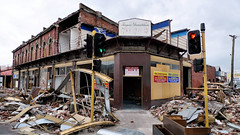
Aftermath of earthquake - shops
Images, eqnz.chch.2010
Aftermath of September 4th Earthquake in Canterbury. Shops on Colombo Street in Christchurch - damaged in earthquake and then partially demolished to reduce risk from unstable materials which might otherwise be dislodged in strong winds or subsequent aftershocks. The 1590 aftershocks recorded to date have continued to cause further damage.

Canterbury Earthquake 2011
Images, eqnz.chch.2010
Our Street - Porta-loo (03.03.2011) Woolston Christchurch Canterbury New Zealand © 2011 Phil Le Cren Photo Taken With: Canon EOS 1000D + Canon EF/EF-S lenses + 10.1 effective megapixels + 2.5-inch TFT color LCD monitor + Eye-level pentamirror SLR + Live View shooting. + EOS Built-in Sensor cleaning system + Wide-are...

Canterbury Earthquake 2011
Images, eqnz.chch.2010
Our Street - Cleaning Up (02.03.2011) Woolston Christchurch Canterbury New Zealand © 2011 Phil Le Cren Photo Taken With: Canon EOS 1000D + Canon EF/EF-S lenses + 10.1 effective megapixels + 2.5-inch TFT color LCD monitor + Eye-level pentamirror SLR + Live View shooting. + EOS Built-in Sensor cleaning system + Wide-a...

Christchurch earthquake
Images, eqnz.chch.2010
The September Canterbury earthquake. These pictures were taken of The New Zealand Army, along with Police, minding the cordons. This was beside The Press building, and behind the Christchurch Cathedral. Note: these photos were taken on a cellphone; mind the quality.

Going in!
Images, eqnz.chch.2010
Working at getting things out of the Victoria Square before it is demolished. www.stuff.co.nz/the-press/news/christchurch-earthquake-20... What I found on my walk around the city January 15, 2014 Ch...
X Marks the Spot
Images, eqnz.chch.2010
What I found on a walk around the city Christchurch November 20, 2013 New Zealand. www.isaactheatreroyal.co.nz/ en.wikipedia.org/wiki/2011_Christchurch_earthquake
BeckerFraserPhotos October 2011 photograph 410
Images, UC QuakeStudies
A pile of rubble from a demolished building on Worcester Street. In the background, the partially demolished Warners Hotel can be seen as well as the Novotel and the PricewaterhouseCoopers Building in the distance. A digger and long-reach excavator can also be seen.
WEMO ERT Set 1 - March 2011 - Photograph 34
Images, UC QuakeStudies
A photograph of the Wellington Emergency Management Office Emergency Response Team standing in a car park on Lichfield Street. The team are wearing face and gas masks, hard hats, safety glasses, knee pads, and rubber gloves. In the background are several earthquake-damaged buildings.

Christchurch Earthquake 2011 - Gnome Away From Home
Images, eqnz.chch.2010
After the liquefaction has been cleaned up we have piles of the stuff on our streets waiting for the council to pick it up. This little Gnome is obviously doing its bit as Christchurch cleans up after the 6.3 magnitude quake 22 February 2011.
The Unswept Leaves of Chancery Lane
Images, UC QuakeStudies
A view down Chancery Lane through cordon fencing. A sign reading "No Entry" is posted on the fence, and fallen leaves have accumulated around the fence and buildings. The photographer comments, "Chancery Lane in the Christchurch CBD red zone looks like it has had no one through at all since the February earthquake".
Rosalee Jenkin Photograph 26
Images, UC QuakeStudies
A photograph looking north down Gayhurst Road, taken from the side of the bridge over the Avon River. Residential properties used to line the left-hand side of the road, and St Paul's church once stood on the corner. This was before the land was red-zoned as a result of the 2010 and 2011 Canterbury earthquakes. Separated cycle ways have recently been installed on both sides of the road. The photograph was modelled off an image taken by Mark Lincoln in September 2010.
Rosalee Jenkin Photograph 24
Images, UC QuakeStudies
A photograph looking north down Gayhurst Road, taken from the side of the bridge over the Avon River. Residential properties used to line the left-hand side of the road, and St Paul's church once stood on the corner. This was before the land was red-zoned as a result of the 2010 and 2011 Canterbury earthquakes. Separated cycle ways have recently been installed on both sides of the road. The photograph was modelled off an image taken by Mark Lincoln in September 2010.
Rosalee Jenkin Photograph 25
Images, UC QuakeStudies
A photograph looking north down Gayhurst Road, taken from the side of the bridge over the Avon River. Residential properties used to line the left-hand side of the road, and St Paul's church once stood on the corner. This was before the land was red-zoned as a result of the 2010 and 2011 Canterbury earthquakes. Separated cycle ways have recently been installed on both sides of the road. The photograph was modelled off an image taken by Mark Lincoln in September 2010.
Nisbet, Alistair, 1958- :Cheaper, stronger, Christchurch iconic building?.…
Images, Alexander Turnbull Library
Refers to the reopening of the Christchurch strip club 'Calendar Girls' after more than a year inside the central-city cordon. The building suffered minimal damage but was inaccessible because damage to neighbouring buildings meant the road (Hereford Street) were closed. Quantity: 1 digital cartoon(s).

Christchurch Earthquake - Under Reconstruction
Images, eqnz.chch.2010
Looks even better when Viewed On Black A view 4 weeks after the 7.1 magnitude earthquake in Christchurch. St Johns Church corner of Hereford Street and Latimer Square. Given a bit of a HDR process to add some of what I was "feeling" at the time.

Christchurch Earthquake - When the World turns Upside-Down
Images, eqnz.chch.2010
A view after the 7.1 magnitude earthquake in Christchurch. Corner of Colombo and Byron Streets. Given a bit of a HDR process to add some of what I was "feeling" at the time. Image featured on: www.lakewanaka.co.nz/new-zealand/Take-a-break-f...
Photograph by Neil Macbeth 266
Images, UC QuakeStudies
Smoke billowing from the remains of the collapsed Canterbury Television Building on Madras Street. Flames are visible through a gap in the intact section of the building. Below, emergency personnel can be seen searching the rubble for trapped people. On the right, two workers are using a piece of corrugated plastic as a slide to remove objects from the rubble.
Photograph by Neil Macbeth 281
Images, UC QuakeStudies
Emergency personnel searching for people trapped in the collapsed Canterbury Television Building on Madras Street. On the right, a man is using a sheet of corrugated plastic to slide pieces of debris off the building. Smoke is billowing from the remains of the building and a jet of water can be seen in the background, attempting to extinguish the fire.
New Zealand Defence Force photograph 688
Images, UC QuakeStudies
Damage to the Lyttelton Hotel on Norwich Quay. The top of the building has crumbled, bringing the roof down with it. Bricks have fallen on the awning and all along the footpath. Wire fencing and road cones have been used to create a cordon around the building.
Christchurch Press Image: Dean Kozanic 2010:12:14 (03)
Images, UC QuakeStudies
Photograph captioned by Fairfax, "Work to restore and earthquake-strengthen the badly damaged historic St Paul's Trinity Pacific Presbyterian Church on Cashel Street has begun after resource consents were granted by the Christchurch City Council, and a preferred contractor was selected recently. Leading hand, Iain Piper (left) and site manager Mike McKee at work on the upstairs seating area".
BeckerFraserPhotos February 2011 photograph 181
Images, UC QuakeStudies
Scaffolding that has been constructed on the Manchester Street face of the Octagon Live Restaurant (formerly Trinity Church), which is being repaired. Masonry has fallen from one of the building's gables, and the resultant gap has been weather proofed with plywood and a tarpaulin. The site has been enclosed in a safety fence that cuts off one lane of the road.
Christchurch Press Image: Dean Kozanic 2010:12:14 (02)
Images, UC QuakeStudies
Photograph captioned by Fairfax, "Work to restore and earthquake-strengthen the badly damaged historic St Paul's Trinity Pacific Presbyterian Church on Cashel Street has begun after resource consents were granted by the Christchurch City Council, and a preferred contractor was selected recently. Leading hand, Iain Piper (left) and site manager Mike McKee at work on the upstairs seating area".