
A CERA information sign on the fence in the Cathedral Square placed to provide information for the public about the buildings seen from Cathedral Square. This one says "BNZ Building: This is a dangerous building. The demolition will begin in the New Year. Once the demolition begins walking access will not be able to continue into Cathedral Square. Plans are currently underway to retrieve tenants' essential items".

A photograph taken from the top of the BNZ building. The photograph is captioned by BeckerFraserPhotos, "From left to right are the Brannigans building (under demolition), former Government Life Building, Farmers building, MFL building (under demolition), Forsyth Barr building (staying) , PricewaterhouseCoopers building (going) and the roof of the cathedral in the foreground".
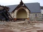
One portrait colour digital photograph taken on 25 September 2011 showing the demolition of the Catholic Church of St Joseph the Worker in Winchester Street Lyttelton. Photograph shows the Transepts, Sanctuary. The damage from the June 2011 aftershocks led to the demolition of the St Joseph Church 146 years after its opening in June 1865. The L...

Demolition of the old Millers building is just about complemented. On my walk around the city in the rain.. thought it may have stopped.. but didn't so I just kept walking! June 12, 2014 Christchurch New Zealand.

I am going away for a short time for a holiday and well get back to you all when I get home.
Demotion of the Victoria Sq apartments on a walk around the city Feb 26, 2014 Christchurch New Zealand.
www...

A photograph of excavators outside Queen Elizabeth II Park.

None

None

None

A photograph of an excavator demolishing a building on Victoria Street.

A photograph of an excavator demolishing a building on Victoria Street.

A photograph of an excavator demolishing a building on Victoria Street.

A photograph of an excavator demolishing a building on Victoria Street.

Construction materials outside a house on Canterbury Street in Lyttelton. The house is being demolished after the 22 February 2011 earthquake. Wire fencing and road cones cordon off the area, and a bulldozer and a digger are parked on the road.

A photograph captioned by Paul Corliss, "Ferrymead Tower. Stripping the insides".

A photograph captioned by Paul Corliss, "Ferrymead Tower. Stripping the insides".

Photograph captioned by BeckerFraserPhotos, "Main Road, Redcliffs".

A photograph captioned by Paul Corliss, "Waters Edge Apartments, Tidal View, Ferrymead".

A photograph captioned by Paul Corliss, "Waters Edge Apartments, Tidal View, Ferrymead".

A photograph captioned by Paul Corliss, "Waters Edge Apartments, Tidal View, Ferrymead".

Photograph captioned by BeckerFraserPhotos, "Corner of Salisbury and Victoria Streets".

A view down London Street in Lyttelton. The road has been closed to traffic because of unstable and damaged buildings in the area. In the background is the Empire Hotel on London Street in Lyttelton. Bracing has been placed on the front of the building to keep it together and limit further damage from aftershocks. The building has been cordoned off with fencing.

A red sticker on the window of a Peterborough Street property.

The fenced-off site of Ground Culinary Centre on London Street in Lyttelton.

A photograph captioned by Paul Corliss, "Waters Edge Apartments, Tidal View, Ferrymead".

A photograph captioned by Paul Corliss, "Bradley Nuttall building, over police wall. Central city".

A photograph captioned by Paul Corliss, "Waters Edge Apartments, Tidal View, Ferrymead".

A photograph captioned by Paul Corliss, "Waters Edge Apartments, Tidal View, Ferrymead".

A photograph of a partially-demolished building. The photograph is captioned by BeckerFraserPhotos, "131 Peterborough Street".

A photograph captioned by Paul Corliss, "Waters Edge Apartments, Tidal View, Ferrymead".