
Oxford Terrace Baptist Church on the corner of Madras St and Oxford Terrace, and alongside the Central City Fire Station on Kilmore St.

One landscape colour digital photograph taken on 19 November 2011 showing buildings on London Street. Visible in the photograph (left to right) are Lyttelton Ambulance Station and Bells Pharmacy - relocated into a converted house with law firm MacTodd on the upper floor. Discussions have been held between Lyttelton Police, St John Ambulance and...

One landscape colour digital photograph taken on 14 September 2012 showing the site of the Harbourlight Theatre on London Street. The retaining wall at the rear of the site collapsed and part of the adjoining land eroded. Also visible in the photograph are the side walls of the Bank of New Zealand and the former Westpac Branch, now Himalaya Desi...

One landscape colour digital photograph taken on 14 September 2012 showing a block of partially demolished shops on the corner of London and Oxford Streets. The businesses (from left to right) are Bells Pharmacy, Leslie's Bookshop and Lyttelton Sea Foods. The site of The Empire Hotel is visible to the right of the photograph. By the time this p...

One portrait colour digital photograph taken on 19 November 2011 showing the flyers in the window of the Lyttelton Information Centre on Oxford Street. The building was closed from 22 February 2011 until April 2013 due to the danger posed by the neighbouring building and then while repairs were scheduled and carried out. The flyers provided a sn...

One landscape colour digital photograph taken on 19 November 2011 showing the temporary premises of Lyttelton Bakery in a relocatable building on Norwich Quay. The building is located on the site of the Royal Hotel. Also visible in the photograph are (left to right up Canterbury Street) Lyttelton Service Station, Samo, Lyttelton Telephone Exchan...

One portrait colour digital photograph taken on 23 July 2011 showing the artwork by Trent Hiles erected on the site of the Harbourlight Theatre on London Street. The artwork presents part of James K Baxter's poem 'High Country Weather' using the international code of signal flags. The artwork was installed as a Gap Filler project. The artwork r...

One landscape colour digital photograph taken on 6 September 2011 showing the demolition of 2 Sumner Road, the former library and fire station. This building was a private residence at the time of its demolition. Photograph taken looking north on Oxford Street. Also visible in the photograph are the Lyttelton Information Centre, an entrance to ...

In the top frames two children shout 'four point one', 'three point six', and 'five point two' and in the frame below it is seen that they are responding to bumps in the road as their mother drives through Christchurch streets. Context - The children have become expert at guessing the seismic intensity of earthquakes in Christchurch and are now applying them to bumps in the road.
Colour and black and white versions available
Quantity: 2 digital cartoon(s).

Damage to TJ's Kazbah in New Brighton. The east and north walls and part of the upper floor have collapsed, tipping rubble and the contents of the rooms out onto the street. The photographer comments, "The occupants of the business and rooms all managed to escape alive. A digger was used to make the building safe and then used to sift through the rubble for any surviving belongings. It was a very emotional time for the ex-occupants".

A photograph of a sign outside the Christchurch Art Gallery advertising the "Debuilding" exhibition which was on display when the 22 February 2011 earthquake hit.

A resident on Moore Street demonstrates how her hand can fit inside a large crack caused by the earthquake.

One metal backed plastic sign, circa 1970s, for Cokers Hotel, Manchester Street, Christchurch detailing hotel services and featuring a map of the central city. The Cokers Hotel was located in central Christchurch at 52 Manchester Street. First licensed by John Etherdan (Jack) Coker in 1867, in 1890 the lease was taken over by Captain Popham, wh...

Photograph captioned by Fairfax, "2010 Canterbury Earthquake. Workers apply steel framing to protect the historic building now the 'Octagon' restaurant on the corner of Manchester Street and Worcester Street".

Photograph captioned by Fairfax, "Police search a building on the corner of St Asaph Street and Barbadoes Street, after reports of a person in the wreckage following Canterbury's earthquake".

A motion-blurred photograph of houses, with the Port Hills in the background. The photographer comments, "This I hope gives you a feel of what it feels like in an earthquake. When you spend your whole life thinking that you and your home are built on solid ground, it can be quite a shock when you find it is not. You can feel the house shaking like a dog with a toy, rising up violently underneath you or the most gentle form which is when the ground moves gently like a wave moving under a rowing boat. It is not just the movement, you often get a rumbling sound which can precede a violent shake or can result in no movement at all. This means that some vehicles can sound like the rumbling initially and in the early days would get your heart racing. Another form of stress is when big excavators as heavy as a tank move as you can feel the ground shake from streets away, but you do not always hear the engine. For most of us the problem when the shaking starts, is wondering if this is the start of an extremely violent earthquake or will it peter out".

Revealed after the SoulFood Cafe building was demolished - Haircutting for 6d and a shave for thruppence? how old is this?

Same view as a previous shot - taken in January 2011 after the block of buildings was demolished.

The window that was hanging precariously finally fell when the Boxing Day 4.9 shock hit at 10.30am

Cross cracks in the brick wall of St Elmo Courts apartment block at the Hereford Street / Montreal Street intersection.

This building at the Barbadoes Street / St Asaph Street intersection was so badly gamaged it had to be demolished.

Cross cracks in the brick wall of St Elmo Courts apartment block at the Hereford Street / Montreal Street intersection.

One portrait colour digital photograph taken on 19 November 2011 showing a poster advertising the planned 2011 Census which was scheduled for Tuesday 8 March 2011. The census was abandoned because of the 22 February 2011 Earthquake. The poster was located in the window of the Lyttelton Information Centre on Oxford Street. The building was closed...
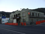
One landscape colour digital photograph taken on 26 May 2013 on the corner of Norwich Quay and Canterbury Street, Lyttelton. The photograph shows the Mitre Hotel surrounded by temporary fencing. Three years after the 2010-2011 earthquakes there are still many uncertainties about which buildings can or will be retained. These buildings, or parts...

None
What I found on a walk around the city Christchurch November 20, 2013 New Zealand.
www.isaactheatreroyal.co.nz/
en.wikipedia.org/wiki/2011_Christchurch_earthquake

NZ Army personnel driving an armoured vehicle through the streets of Christchurch after the 22 February 2011 earthquake.

A photograph looking south down Colombo Street towards the earthquake-damaged ChristChurch Cathedral. A crane is sitting on the road in front of the Cathedral. In the background is a pile of rubble from the partially-demolished tower.

Photograph captioned by Fairfax, "City Care workers repair broken water pipes on Matipo Street, probably caused by the morning's earthquake".

Photograph captioned by Fairfax, "Post-earthquake demolition. Materials from a building on St Asaph Street still waiting to be cleared".