
Photograph captioned by BeckerFraserPhotos, "High Street shops".

A photograph of computers and desks from the Department of Civil and Natural Resources Engineering at the University of Canterbury. These were set up in the Sunday School room of the Avonhead Baptist Church after the 22 February 2011 earthquake.

A photograph of computers and desks from the Department of Civil and Natural Resources Engineering at the University of Canterbury. These were set up in the Sunday School room of the Avonhead Baptist Church after the 22 February 2011 earthquake.

A view across Armagh Street to the Cranmer Centre. Scaffolding has been constructed on the building's Armagh Street face, while on the Montreal Street side masonry from the walls has collapsed onto the road.

Photograph captioned by BeckerFraserPhotos, "University grounds, College House, and Bishop Julius hall of residence, with the new supermarket under construction at centre right".

Photograph captioned by BeckerFraserPhotos, "Design and Art College, 116 Worcester Street".

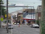
Photograph captioned by BeckerFraserPhotos, "High Street".

Earthquake damage down New Brighton Road. There is cracking on the footpath and cars are parked on the front lawns as silt from liquefaction still remains on the street curb. A van with a 'school' sign can be seen driving down the road.

Photograph captioned by BeckerFraserPhotos, "116 Worcester Street".

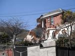
Damage to the building that housed the LSI English Language School on Peterborough Street. The side wall where bricks have fallen from has been covered up, and the area around the building has been cordoned off. Piles of bricks are still visible on the site.

Photograph captioned by BeckerFraserPhotos, "Cashel Mall".

Photograph captioned by BeckerFraserPhotos, "Looking from north-east to south-west across the Arts Centre, Christ's College and Hagley Park".

Photograph captioned by BeckerFraserPhotos, "South Hagley Park with the hospital at bottom left".
One landscape colour digital photograph taken on 25 February 2011 showing earthquake damage on western side of Oxford Street, Lyttelton Taken from the footpath looking downhill from Lyttelton Main School. The buildings visible (from the foreground) are: London Street Restaurant; Bells Pharmacy; Maritime House (McKay - ISS Limited, Shipping Ag...

One landscape colour digital photograph taken on 25 February 2011 showing earthquake damage on eastern side of Oxford Street, Lyttelton Taken from the footpath looking downhill from opposite Lyttelton Main School. The Buildings visible are the premises of Moda Fotografica (former Library and Council Chambers), a private residence (former Libra...

Photograph captioned by BeckerFraserPhotos, "Design and Arts College of NZ, Kaplan House, 116 Worcester Street".

Photograph captioned by BeckerFraserPhotos, "The Cashel Street and High Street intersection used to be very dominated by buildings".

Photograph captioned by BeckerFraserPhotos, "Detail of Christ's College".

One landscape colour digital photograph taken on 25 February 2011 showing the temporary water tank installed on the grassy [local name for Lyttelton Main School Field] to provide drinking water for residents to collect when there was no town supply water. A temporary source of drinking water was needed following the 22 February 2011 earthquake...

Photograph captioned by BeckerFraserPhotos, "New Cashel Mall centre left".

Photograph captioned by BeckerFraserPhotos, "CBD. Looking north between Colombo and Manchester Streets".

Photograph captioned by BeckerFraserPhotos, "CBD with Christ's College in the foreground, Canterbury Museum and the Arts Centre".
One landscape colour digital photograph taken on 6 September 2011 showing demolition of the former Convent of Our Lady of Mercy. St Mary's School, run by the Sisters of Mercy, was also housed in this building. At the time of the 4 September 2010 earthquake the building was a private residence. Three years after the 2010-2011 earthquakes there a...

One landscape colour digital photograph taken on 12 April 2011 showing earthquake damage to the former Convent of Our Lady of Mercy. St Mary's School, run by the Sisters of Mercy, was also housed in this building. At the time of the 4 September 2010 earthquake the building was a private residence. The sense of loss felt when confronted with the...

One landscape colour digital photograph taken on 25 September 2011 showing the remaining portion of the former Convent of Our Lady of Mercy. St Mary's School, run by the Sisters of Mercy, was also housed in this building. At the time of the 4 September 2010 earthquake the building was a private residence. The picture shows the perimeter wall, t...

Photograph captioned by BeckerFraserPhotos, "The remains of SBS House, on the south-east corner of Worcester and Manchester Streets. The Octagon Live is behind".

Photograph captioned by BeckerFraserPhotos, "The CBD with Fanzone and Christ's College in the foreground, Arts Centre to the right".

Photograph captioned by BeckerFraserPhotos, "The city blocks encompassed by Manchester Street, Gloucester Street, Latimer Square and Hereford Street are amongst those with the most demolished buildings in the city centre at the moment".

Photograph captioned by BeckerFraserPhotos, "The city blocks encompassed by Manchester, Gloucester, Latimer Square and Hereford Streets are amongst those with the most demolished buildings in the city centre at the moment".

Photograph captioned by BeckerFraserPhotos, "Central city with the BNZ at the bottom right, the Hotel Grand Chancellor, Westpac Building and Holiday Inn clustered in the bottom centre, and Latimer Square upper".