
Emergency personnel lifting a metal beam from the ruins of the Canterbury Television Building on Madras Street during their search for trapped people.

A photograph of a map used by emergency management personnel to inspect buildings after the 22 February 2011 earthquake. The map is of the block bordered by Barbadoes Street, Worcester Street, Gloucester Street, and Fitzgerald Avenue. Many of the buildings have been highlighted in blue, with some smaller buildings highlighted in orange. Numbers and messages have been written on the map with biro.

A photograph of several earthquake-damaged and partially-demolished buildings on Manchester Street near the intersection of Lichfield Street. To the right two emergency management personnel are taking photographs from the intersection. On the other side of the intersection there are several chairs, tables, and a couch under a red umbrella. Another member of an emergency management team is sitting on the couch.

A photograph of emergency management personnel examining the earthquake damage to the Flight Centre's Link Centre on High Street. A brick wall on the neighbouring building has collapsed, falling through the roof of the store, and spilling out into the street. To the left, USAR codes have been spray-painted on the windows of the Coffee Culture.

A photograph of emergency management personnel walking down Manchester Street towards the intersection of High and Lichfield Streets. Many of the buildings on the left side of the road have been damaged by the earthquakes. In the distance rubble from the earthquake-damaged buildings has spilled onto the road. Steel fences have been placed along the footpath to the left.

A photograph of a map used by emergency management personnel to inspect buildings after the 22 February 2011 earthquake. The block between St Asaph, Antigua, Montreal, and Acton Street has been outlined with a red felt-tip pen. Some of the buildings in the block and below Acton Streets have been coloured orange. A few other buildings have been coloured blue.

A photograph of emergency management personnel examining the back of a building on Tuam Street. Scaffolding has been constructed up the sides of the building and wire fencing has been placed around the back. To the right is a large pile of rubble from other earthquake-damaged buildings. Rubble is also piled up on the side of the road in the distance.

Damage to Wave House on Gloucester Street (Winnie Bagoes Pizza Bar). The roof and left side of the building have collapsed and crumbled into the street, crushing several cars. Emergency personnel have spray painted two of the cars with the word "Clear" to indicate they have been checked for trapped or injured people. The scene has been cordoned off by New Zealand Fire Service tape.

A photograph of emergency management personnel in the foyer of the Christchurch Art Gallery. The art gallery was used as the temporary Civil Defence headquarters after the 22 February 2011 earthquake. In the background, a cherry picker can be seen.

A photograph of emergency management personnel in the foyer of the Christchurch Art Gallery. The art gallery was used as the temporary Civil Defence headquarters after the 22 February 2011 earthquake. In the background, a cherry picker can be seen.

Emergency personnel using a crane to check the Forsyth Barr building for people trapped after the 22 February earthquake. On the intersection of Armagh Street and Colombo Street below, police and fire service personnel are gathered. The road below is severely warped.

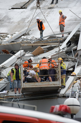
Emergency personnel using a crane to rescue a woman from the collapsed Pyne Gould Corporation building in the aftermath of the 22 February 2011 earthquake.

Emergency personnel using a crane to rescue a woman from the collapsed Pyne Gould Corporation building in the aftermath of the 22 February 2011 earthquake.

Emergency personnel using a crane to rescue a woman from the collapsed Pyne Gould Corporation building in the aftermath of the 22 February 2011 earthquake.

Emergency personnel using a crane to rescue a woman from the collapsed Pyne Gould Corporation building in the aftermath of the 22 February 2011 earthquake.

Emergency personnel using a crane to rescue a woman from the collapsed Pyne Gould Corporation building in the aftermath of the 22 February 2011 earthquake.

Emergency personnel using a crane to rescue a woman from the collapsed Pyne Gould Corporation building in the aftermath of the 22 February 2011 earthquake.

Emergency personnel using a crane to rescue a woman from the collapsed Pyne Gould Corporation building in the aftermath of the 22 February 2011 earthquake.

Emergency personnel using a crane to rescue a woman from the collapsed Pyne Gould Corporation building in the aftermath of the 22 February 2011 earthquake.

Emergency personnel using a crane to rescue a woman from the collapsed Pyne Gould Corporation building in the aftermath of the 22 February 2011 earthquake.

Emergency personnel using a crane to rescue a woman from the collapsed Pyne Gould Corporation building in the aftermath of the 22 February 2011 earthquake.

Emergency personnel using a crane to rescue a woman from the collapsed Pyne Gould Corporation building in the aftermath of the 22 February 2011 earthquake.
Emergency personnel using a crane to rescue a woman from the collapsed Pyne Gould Corporation building in the aftermath of the 22 February 2011 earthquake.

A photograph of the earthquake damage to a building on the corner of Hereford and Madras Street. Sections of the façade have crumbled, bricks spilling onto the road in front. Wire fencing has been used to block off half of Madras Street. In the background, emergency management personnel are working through the rubble of the CTV building site. A digger and a crane are parked on the site.

A photograph of a map used by emergency management personnel to inspect buildings after the 22 February 2011 earthquake. The map is of central Christchurch. Almost all of the blocks outside four streets (Moorhouse Avenue, Oxford Terrace, Kilmore Street, and Barbadoes Street) have been highlighted in yellow. Latimer Square has also been highlighted. A message written at the top of the map reads, "Query pile checked by dogs".

Smoke billowing from the remains of the collapsed Canterbury Television Building on Madras Street. Below, emergency personnel can be seen searching the rubble for trapped people.

A photograph of a member of an emergency management team standing in the middle of the intersection of Manchester, High, and Lichfield Streets. In the background an excavator is sitting on top of a pile of rubble from several earthquake-damaged buildings. Other emergency management personnel are also standing on the corner of High and Manchester Streets. Behind the excavator another excavator is working to clear rubble. To the right there is a block of earthquake-damaged buildings and more building rubble to be cleared.

A photograph of a map used by emergency management personnel to inspect buildings after the 22 February 2011 earthquake. The map is of the block bordered by Barbadoes Street, Worcester Street, Gloucester Street, and Fitzgerald Avenue. Many of the buildings have been highlighted in blue, with some smaller buildings highlighted in orange. Two blocks of buildings have been outlined in dark-blue felt-tip pen. Numbers and messages have been written on the map with biro.

Emergency personnel treating a wounded woman at the medical centre set up in Latimer Square. In the background, earthquake victims can been seen, wrapped in blankets for warmth.

Emergency personnel treating a wounded woman at the medical centre set up in Latimer Square. In the background, earthquake victims can been seen, wrapped in blankets for warmth.