
Damaged pavement on the Williams Street bridge in Kaiapoi. The concrete abutment has risen during the earthquake, forcing its way through the pavement of the footpath into the open.

Damaged pavement on the Williams Street bridge in Kaiapoi. The concrete abutment has risen during the earthquake, forcing its way through the pavement of the footpath into the open.

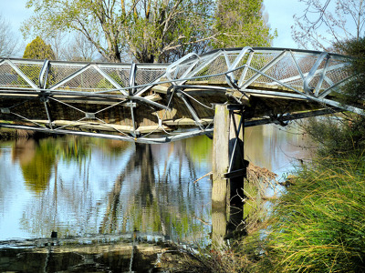
The damaged Snell Place footbridge. A crack is visible at the apex of the span. The photographer comments, "Before the Christchurch earthquakes this bridge used to be just just 9 feet at high tide above the River Avon. Now with the ends pushed together it has probably moved up another 9 feet".
The badly twisted Medway Street footbridge. The photographer comments, "The September 4th 2010 earthquake in Christchurch was so violent that the banks of the Avon River moved towards each other. This footbridge being metal had to twist sideways to release the pressure of being pushed from both river banks. It looked like it had been wrung out like a wet towel".

A damaged wooden footbridge across the Avon River beside University Drive is blocked off with sheets of plywood and danger signs. The photographer comments, "The University restarts its teaching, and the techies in e-learning move out of NZi3. The bridge to the Rec Centre".

Damage to River Road in Richmond. The road surface is badly cracked and slumped, and liquefaction silt covers part of the road. Two people in gumboots walk towards a barrier erected across the road using road cones and warning tape, and in the background the badly twisted Medway Street bridge can be seen. The photographer comments, "Longitudinal cracks indicate lateral movement as the land sagged towards the river. Near 373 River Rd, looking south-east towards Medway St. The Medway St bridge is visible in the background".

A Simple shot down the street where the shops are now marked for demolition.
Twitter | Facebook | My Website |

One Month after the Christchurch Earthquake. A view in Sydenham suburb - Columbo St
Twitter | Facebook | My Website |

A corner shop in Sydenham - a Suburb of Christchurch. Front walls are all missing
Twitter | Facebook | My Website |

Photograph captioned by Fairfax, "Members of the Red Cross civil defence response team and South Canterbury Police have been in Christchurch helping with the earthquake clean up. Having a look at a damaged bridge on River Road near Tai Tapu is Anna Sole".

A sewage pumping station on Avonside Drive has been lifted out of the ground by liquefaction. In the background, the damaged Snell Place footbridge over the Avon River is closed off with cordon fencing. The photographer comments, "A Sunday afternoon ride to New Brighton, then back via Aranui, Wainoni, Dallington, and Richmond. Not a cheerful experience. Dallington footbridge. The two pieces of this foot bridge have moved towards each other, so the bridge has developed quite a peak. The sewage pumping station has been heaved out of the ground by hydraulic pressure during quakes".

One Month after the Christchurch Earthquake. The remains of a Church in St albans, Edgeware Rd
Twitter | Facebook | My Website | <...

One Month after the Christchurch Earthquake. This is in Kaiapoi at the north end of Christchurch. A view down the walkway next to the river
Twitter | Facebook |

Photograph captioned by Fairfax, "Members of the Red Cross civil defence response team and South Canterbury Police have been in Christchurch helping with the earthquake clean up. Welfare checks required the team to walk along River Road checking on householders. Pictured looking at a damaged bridge on River Road near Tai Tapu are (from left) Andy Todd, Anna Munro and Ken Weavers".

There are quite a few signs like this around Christchurch after the Quake. This is one of them. Off shot to the right is a leveled patch of ground where the owners furniture restoration shop used to be.
Twitter |

Photographs of central Christchurch after the 2010-2012 earthquakes taken 25 February 2012 by Sean McMahon. Locations are chiefly Manchester, Saint Asaph, Cashel, Columbo and Lichfield Streets, and the Bridge of Remembrance. Images show fencing around areas closed to the public, damaged and collapsed commercial buildings, cleared sites, re-opened Cashel Street area with shops and a cafe.
Source of title - Title supplied by Library
Quantity: 34 digital photograph(s).

20111230_7222_1D3-70 New Brighton
Further damage to the bank following the two quakes on 23/12/11. The sewer line broke here and was repaired (patched) by council staff on Christmas Eve. It is hard to beleve that this rock wall was level with the land here, before any of the quakes.
#2004