Search
found 201 results
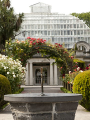
20121124_0566_1D3-67 Cunningham House
Images, eqnz.chch.2010
Cunningham House at the Christchurch Botanic Gardens is still closed due to earthquake damage. I wonder if it will ever re-open or suffer the demolition fate many other iconic structures in Christchurch have.

20120131_8153_1D3-400 Conatiner wall
Images, eqnz.chch.2010
Part of the container wall to stop rock falls on Main Road, Sumner.
20130424_6254_1D3-400 South New Brighton Jetty - 2
Images, eqnz.chch.2010
The jetty in the South New Brighton Domain was rebuilt a few years ago. It was straight and level till the earthquakes. Has been closed for 2½ years now.

20130312_0936_EOS M-27 T-Rex
Images, eqnz.chch.2010
Went for a drive down to South New Brighton/Southshore after work today to see what interesting birds I could find on the Estuary (godwits, skuas, terns etc), but passing Jellico Street, I saw this. T-Rex the seismic survey truck from the University of Texas that is visiting the city (first time out of USA). Weighs 30 tonne and from the marks o...

Bridge Street split depth - Christchurch earthquake
Images, eqnz.chch.2010
20100905_3347_1D3-32 Bridge Street split depth - Christchurch earthquake The city side of the South Brighton bridge. Approaches on both sides will need extensive work before this bridge can re-open. Bridge opened for traffic less than a week later, but still (23/09) has 30kmh speed restriction. #378

Deans Homestead October 2008
Images, eqnz.chch.2010
20081011_1524_1D3-45 Deans Homestead October 2008 The historic Deans Homestead 23 months ago. Now destroyed in the Canterbury earthquake of September 4th 2010. This photo was taken on the PSNZ 2008 Southern Regional Photographic Convention bus trip. #384

20160307_6619_7D2-125 Covering up
Images, eqnz.chch.2010
One of the most beautiful pieces of wall art (added to the blank walls after buildings were demolished following the earthquakes) in Christchurch, is now being hidden by a new building in front of it. www.flickr.com/photos/johnstewartnz/15499321681/in/...

20160307_6626_7D2-200 Pigeon City
Images, eqnz.chch.2010
Pigeons sit on the remains of one of the tallest buildings in Christchurch that was 95% demolished two or three years ago. The basement (now filled with water) and the columns remain. Demolished due to damage from the Christchurch 2011 earthquake.

20160703_144759_GT-S7275T-04 New sea wall at Redcliffs (185/366)
Images, eqnz.chch.2010
20160703_144759_GT-S7275T-04 New sea wall at Redcliffs (185/366) I went for a drive in my second car mainly to charge the battery up and forgot to take my camera gear so only had my phone. This is the new rock wall to replace the severely damaged previous one (in the February 2011 earthquake). Work is still underway on the car parking and p...

Six years on
Images, eqnz.chch.2010
20161211_0216_1D3-24 Six years on A view that was impossible six years ago. There was a group of buildings including another high-rise in the vacant area in the middle ground. #7986

20170918_6084_7D2-41 Demolition still happening (260/365)
Images, eqnz.chch.2010
20170918_6084_7D2-41 Demolition still happening (260/365) Six ½ years after the earthquakes there are still a few demolitions taking place. This one is a block of council owned flats. Whether the whole complex is being demolished or not I don't know., but here the centre block of three is being demolished. The green grass is what was sections...

20120131_8167_1D3-400 Shag Pile
Images, eqnz.chch.2010
What more can one say except that Shag Rock is now about one third it's original height. Whitewash Head in the background with the road that now drops over a cliff.

20130207_2231_1D3-165 Sumner and "container alley"
Images, eqnz.chch.2010
Nearly 80 40 foot containers (most two high) protect Wakefield Avenue in Sumner from further rock falls. Behind these (to the left) are houses, church, bowling club, RSA (Returned Servicemens Association) and other community buildings that have been isolated now for nearly two years now. On the right upper third boundary (just behind two stand a...

20130130_1861_1D3-47 St Lukes in the City - labyrinth
Images, eqnz.chch.2010
According to the sign it can take about 30 minutes to walk from the entry point (near the small statue) to the centre and out again. What you can do with a few thousand old bricks and gravel. See next photo for more detail.

20120129_8116_1D3-200 Pleasant Point Yacht Club
Images, eqnz.chch.2010
The small wharf area of the now gone Pleasant Point Yacht Club has already been taken over by the Pied Shags (cormorants). It is under water now except for low tide. Note the dead pine tree in background. Many have died because of the salt water their roots are in.

20111230_7222_1D3-70 New Brighton
Images, eqnz.chch.2010
20111230_7222_1D3-70 New Brighton Further damage to the bank following the two quakes on 23/12/11. The sewer line broke here and was repaired (patched) by council staff on Christmas Eve. It is hard to beleve that this rock wall was level with the land here, before any of the quakes. #2004

20130424_6246_1D3-400 South New Brighton Jetty - 3
Images, eqnz.chch.2010
The jetty in the South New Brighton Domain was rebuilt a few years ago. It was straight and level till the earthquakes. Has been closed for 2½ years now. The shags like it though!
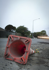
20120321_2416_1D3-24 Fallen Cone
Images, eqnz.chch.2010
A month after the 1st anniversary of the deadly Christchurch earthquake (22/02/11) a road cone lies on New Brighton Road, alongside the Avon River. Part of the earthquake 1st anniversary remembrance was for people to place flowers in road cones (and there are hundreds of thousands in the city). Many had flowers in them, as this one did. Photo ...

20120805_7436_1D3-600 Newstalk ZB building starting to go down 01
Images, eqnz.chch.2010
Shot from up Hunstbury Hill with a 600mm f/4 on a very grey morning. 8am demolition. The guy behind me only looked up when the sounds of the explosion reahed us and the building was half way down!

20130123_1662_1D3-35 Canterbury substation (Day 23/365)
Images, eqnz.chch.2010
The electrical supply substation built into the Lion Breweries Canterbury Draught brewery in St Asaph Street, Christchurch. Now the whole complex is being demolished due to earthquake damage.

Christchurch earthquake
Images, eqnz.chch.2010
20100904_3309_1D3-24 Christchurch earthquake Wairoa Street Another web site used this image (with a link to this Flickr page), so the view count sky rocketed. CERA (Canterbury Earthquake Recovery Authority)/Tonkin & Taylor also used this image on page 13 of a Land Damage presentation on 23/06/11. This was also released as a PDF. A few mo...

Castle Rock
Images, eqnz.chch.2010
20100913_3424_1D3-400 Castle Rock The damage to Castle Rock, overlooking the Heathcote Valley from the 7.1 earthquake on September 4th. #385

20160307_6607_7D2-110 Interior removal
Images, eqnz.chch.2010
The Forsyth Barr building has stood silent and empty (except the occasional intruder and pigeons) since the February 2011 earthquake. It was sold "as is" and I understand that it is now going to be fitted out as a hotel. This is the building that had severe stairwell damage during the quake necessitating people being lowered via ropes etc on t...
20110307_2009_1D3-85 Liquefaction silt pile [EQNZ]
Images, eqnz.chch.2010
This is a temporary pile of silt piled on the old Bexley landfill sight. Some trucks are addng to the pile, while other truck and trailer units are taking it away to the old Bottle Lake landfill sight, a few km to the north of here.

The Wobbly Jetty - 2
Images, eqnz.chch.2010
20160415_0044_1D3-38 The Wobbly Jetty - 2 The South New Brighton jetty was rebuilt a couple of years before the earthquakes wrecked it. Was closed to the public for about four years but is open now. #7222

20120128_8071_1D3-400 Redcliffs wall
Images, eqnz.chch.2010
The sea wall at Beachville Road, Redcliffs, after the earthquake. It used to be straight and level - not now! As a teenager I went fishing off this wall.

20110228_1595_1D3-24 The Clean Up [EQNZ]
Images, eqnz.chch.2010
Cleaning up Manning Signs of the silt from liquefaction. Three fellow workers man the shovels while two building engineers talk to the boss (hidden). After doing the car park we then turned our hands to the inside of the factory, once clearance was given that we could go inside.

20160613_0044_7D2-100 Jetty Closed
Images, eqnz.chch.2010
The South New Brighton jetty has been closed for 3 or 4 years (fenced off) then the fence was removed and it was "open", but nothing has happened to it since the earthquakes, but it is closed again now, although it looks like a home made sign!

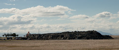
20140112_7509_1D3-70 Remains (My City in Ruins) (SH 8)
Images, eqnz.chch.2010
Scavenger Hunt 101 - SH 8 (abandoned building or ruin) The ruins/remains of what was the third highest building in Christchurch, pre earthquakes, the Price Waterhouse Coopers building in Armagh Street. At 76.3 metres ( 21 floors) the demolition has left the basement (now flooded) and these supports. Just one of many photos from Christchurch ...
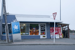
20120321_2397_1D3-47 Beachcomber Dairy
Images, eqnz.chch.2010
20120321_2397_1D3-47 Beachcomber Dairy Corner of New Brighton Road and Rawson Street, New Brighton. This diary is inside the suburban red zone and will probably be demolished some time in the future. See how the earthquakes have moved the footpath - the post and phone box used to stand straight! This is one of the Teleccom Wi-Fi hotspot boo...