
A photograph taken in Cathedral Square, looking north east.

A photograph of fencing in Victoria Square.

Photograph captioned by BeckerFraserPhotos, "37 Latimer Square".

Photograph captioned by BeckerFraserPhotos, "37 Latimer Square".

A photograph of the AMI building on Latimer Square.

A photograph taken in Cathedral Square, looking north west.

None

An aerial photograph looking east over Christ Church Cathedral and down Worcester Street.

A photograph of children standing on the plinth where the statue of John Robert Godley, Canterbury's founder, once stood. Members of the public are viewing the damaged cathedral from a walkway that was opened up between Re:Start Mall and Cathedral Square to allow temporary public access.

Photograph captioned by BeckerFraserPhotos, "Cathedral Square walk through, which allowed citizens of Christchurch to view the Cathedral freely for the first time since 22 February when it was put behind a cordon for safety reasons".

A photograph of the Heritage Hotel, taken from Cathedral Square.

A photograph of the Government Life building in Cathedral Square.

A photograph of the Grant Thornton building in Cathedral Square.

People serving hot drinks and snacks in Cranmer Square.

Photograph captioned by BeckerFraserPhotos, "37-39 Latimer Square".

Photograph captioned by BeckerFraserPhotos, "37-39 Latimer Square".

On the Govt. Life building in the Square ready for demolition

A snapshot from GPS Boomerang's SmartBird flight over the Christchurch red zone on 5 June 2012, looking over Victoria Square with the Forsyth Barr Building, the Victoria Apartments and the PriceWaterHouseCoopers Building visible.
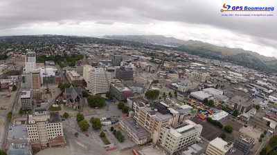
A snapshot from GPS Boomerang's SmartBird flight over the Christchurch red zone on 5 June 2012, looking over Latimer Square with the CTV Building site visible on the right.

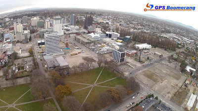
A snapshot from GPS Boomerang's SmartBird flight over the Christchurch red zone on 23 December 2012, looking over Victoria Square with the Forsyth Barr Building and the Victoria Apartments visible. The PriceWaterHouseCoopers Building has been demolished.
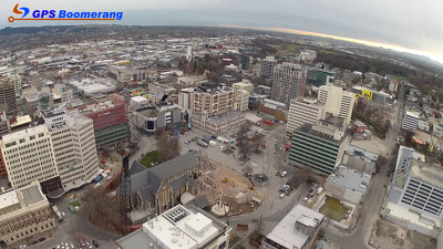
A snapshot from GPS Boomerang's SmartBird flight over the Christchurch red zone on 23 December 2012, looking over Cathedral Square with the Christchurch Cathedral, the Post Office Building and the Chalice visible. The Holiday Inn has been demolished and the demolition of Clarendon Towers is almost complete.

A snapshot from GPS Boomerang's SmartBird flight over the Christchurch red zone on 23 December 2012, looking over Latimer Square with the CTV Building site visible on the right.

A snapshot from GPS Boomerang's SmartBird flight over the Christchurch red zone on 23 December 2012, looking over Cathedral Square with the Cathedral and the Post Office visible. The BNZ Building has been partially demolished.
A snapshot from GPS Boomerang's SmartBird flight over the Christchurch red zone on 5 June 2012, looking over Cathedral Square with the Cathedral and the Post Office visible.

A snapshot from GPS Boomerang's SmartBird flight over the Christchurch red zone on 5 June 2012, looking over Cathedral Square with the Christchurch Cathedral, the Post Office Building and the Chalice visible.

The Christchurch Cathedral after loosing its tower and spire after the 6.3 quake hit Christchurch 22 February 2011. The February 22 quake cracked pillars, twisted walls, shattered stained glass, collapsed buttresses, fractured masonry and toppled the tower. The rose window in the west wall collapsed in the June aftershocks. Demolition of the Chr...

Wednesday 11 April 2012.
File reference: CCL-2012-04-13-IMG_1344
From the collection of Christchurch City Libraries.

File reference:
CCL-2012-02-22-IMG_9684
From the collection of Christchurch City Libraries.

File reference: CCL-2012-02-19-IMG_0269
From the collection of Christchurch City Libraries.

A photograph of the earthquake damaged Press building in Cathedral Square.