
A photograph of an abandoned property in Bexley.

A photograph of a study area in a flat on Poplar Street taken during the Residential Access Project. The project gave residents temporary access within the red-zone cordon in order to retrieve items from their homes. Books and papers have been strewn across the ground.

A photograph of a house surrounded by liquefaction. The photograph is captioned by BeckerFraserPhotos, "125 Cass Street, Kaiapoi".

A photograph of a room inside a flat on Poplar Street taken during the Residential Access Project. The project gave residents temporary access within the red-zone cordon in order to retrieve items from their homes. The building's outer wall has crumbled leaving the room exposed.

A photograph of workers loading a trailer with items salvaged from people's homes during the Residential Access Project. The project gave residents temporary access within the red-zone cordon in order to retrieve items from their homes.

A large crack on the side of a residential road in Avonside. Cones have been placed on the crack to warn road users. In the background, piles of liquefaction have been dug out of residential properties and placed on the road for collection.

A photograph captioned by BeckerFraserPhotos, "A residential property on Kingsford Street in the Horseshoe Lake district". A portaloo on the side of the road has been wrapped in tinsel for Christmas.

An aerial photograph of Viscount Place in the Horseshoe Lake residential area. The photograph has been captioned by BeckerFraserPhotos, "Viscount Place and Alice Street are leading off Kingsford Street, Horseshoe Lake".

An aerial photograph of the Horseshoe Lake residential area. The photograph has been captioned by BeckerFraserPhotos, "Kingsford Street on the left and the end of Tasman Place on the right, Horseshoe Lake".

An aerial photograph of Viscount Place in the Horseshoe Lake residential area. The photograph has been captioned by BeckerFraserPhotos, "Viscount Place and Alice Street are leading off Kingsford Street, Horseshoe Lake".

A photograph captioned by BeckerFraserPhotos, "Residential properties on Alice Street in the Horseshoe Lake district". A road cone on the side of the road has been decorated with tinsel for Christmas.

A map showing likely residential land availability in the Eastern Waimakariri district.

An infographic giving the history of suburbs in the residential red zone.

A photograph of a road cone and sign in a residential area.

Mess inside an abandoned shed in a residential property on Birch Street.

A photograph of liquefaction and flooding in a residential street in Christchurch.

A digger and workers working on road remediation in a residential area.

A digger and workers working on road remediation in a residential area.
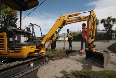
A digger and workers working on road remediation in a residential area.

Damage to residential properties. In the background is a damaged brick property.

A digger and workers working on road remediation in a residential area.

A photograph of an overgrown residential property at 191 New Brighton Road.

Liquefaction in the driveway of a residential property on Birch Street, Bexley.

Mess inside an abandoned shed in a residential property on Birch Street.

A photograph of Danica Nel and other workers standing in line with their authorization forms for the Residential Access Project. The project gave residents temporary access within the red-zone cordon in order to retrieve items from their homes after the 22 February 2011 earthquake.

A photograph captioned by BeckerFraserPhotos, "Residential properties on Kokopu Lane in Bexley". A sign on the side of the road reads, "If you don't live down drive, do not drive down it you are trespassing!! Private Lane".

An aerial photograph of New Brighton. The photograph has been captioned by BeckerFraserPhotos, "Anzac Drive Bridge over the River Avon. The houses in the bottom half of this photograph are residential red zoned".

A photograph captioned by BeckerFraserPhotos, "A residential property on the corner of Queensbury and Goodman Street in the Horseshoe Lake district". A road cone of the side of the road has been decorated with a fabric angel.

A photograph of workers from the Residential Access Project sitting outside the Alice in Videoland Building on the corner of Tuam and High Streets. The project gave residents temporary access within the red-zone cordon in order to retrieve items from their homes.

An aerial photograph of Burwood. The photograph has been captioned by BeckerFraserPhotos, "This area of houses circumscribed by a green belt in a horseshoe shape is called Horseshoe Lake, and is all residential red zoned".