
An aerial photograph of a residential area in Burwood. The photograph has been captioned by BeckerFraserPhotos, "New Brighton Road and Avonside Drive with the Avondale Road bridge. This area is red-zoned on the right-hand side of the river and green-zoned on the left-hand side of the river".

A photograph of workers from the Residential Access Project walking down Tuam Street. The project gave residents temporary access within the red-zone cordon in order to retrieve items from their homes.

Photo of the earthquake damage of a residential property brick fence in Christchurch taken by Marcus Langman, 10 March 2011.

A photograph captioned by BeckerFraserPhotos, "A residential property on the corner of Jean Batten Place and Liggins Street in the Horseshoe Lake district".

A photograph captioned by BeckerFraserPhotos, "Residential properties on Kingsford Street in the Horseshoe Lake district". A sign on a power pole reads, "Viewing. Kiwi - $2, tourist - $5".

A photograph captioned by BeckerFraserPhotos, "A residential property on the corner of Liggins Street and Jean Batten Place in the Horseshoe Lake district".

A photograph captioned by BeckerFraserPhotos, "A residential property on the corner of Jean Batten Place and Liggins Street in the Horseshoe Lake district".

An aerial photograph of a cul de sac at the end of Goodman Street in the Horseshoe Lake residential area.

An infographic giving statistics on the residential red zone.

A montage of photographs of the residential red zone.

An aerial photograph of a residential area in Bexley.

An aerial photograph of a residential area in Bexley.

An aerial photograph of a residential area in Avonhead.

Workers working on underground remediation to a residential house.
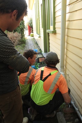
Workers working on underground remediation to a residential house.

Autumn leaves on the trees along a residential street.

Workers working on underground remediation to a residential house.

Building wreckage behind a residential property on Peterborough Street.

An aerial photograph of a residential area in Kaiapoi.

Abandoned furniture on the sidewalk in a residential area.

An aerial photograph of a residential area in Burwood.

Detail of an overgrown property in a residential area.

A photograph of liquefaction at a residential property in Bexley.

A photograph of liquefaction at a residential property in Bexley.

Graphs comparing residential property prices across Christchurch and New Zealand.

Graphs comparing residential property prices across Christchurch and New Zealand.

A photograph of liquefaction at a residential property in Bexley.

A photograph of liquefaction at a residential property in Bexley.

Graphs comparing residential property prices across Christchurch and New Zealand.

Graphs comparing residential property prices across Christchurch and New Zealand.