
A car mired in liquefaction in a car park on Chester Street in the aftermath of the 22 February earthquake. Behind it, the collapsed Durham Street Methodist Church can be seen.

A photograph of an earthquake damaged road in Christchurch. Road cones, cracks, and the remants of liquefaction can be seen on the road. There is a queue of traffic along the street.

A photograph captioned by Paul Corliss, "Avonside and Retreat Roads post earthquake".

A large crack in the ground at Sullivan Park in Avonside which has resulted from the 4 September 2010 earthquake. Remnants of liquefaction silt can be seen around the edges of the crack.

A large crack in the ground at Sullivan Park in Avonside which has resulted from the 4 September 2010 earthquake. Remnants of liquefaction silt can be seen around the edges of the crack.

Liquefaction dug out of properties and piled on the streets in Avonside after the September 4th earthquake.

Liquefaction and damage to tiles in front of a store in Kaiapo, after the September 4th earthquake.

A map showing the extent of liquefaction caused by the 4 September 2010 and 22 February 2011 earthquakes.

Photograph captioned by Fairfax, "Day after the earthquake that rocked Christchurch. Liquefaction in a backyard at Kairaki Beach".

Damage to River Road in Richmond. The road surface is badly cracked and slumped, and liquefaction silt covers part of the road. The photographer comments, "Lateral spreading cracks in River Rd".

Damage to Christchurch city following the 22 February earthquake 2011. A car sits in a hole created by liquefaction on Ferry Road. Piles of silt can be seen around the car.

A large crack in the ground at Sullivan Park in Avonside which has resulted from the 4 September 2010 earthquake. Remnants of liquefaction silt can be seen around the edges of the crack.

A large crack in the ground at Sullivan Park in Avonside which has resulted from the 4 September 2010 earthquake. Remnants of liquefaction silt can be seen around the edges of the crack.

A photograph of a silt volcano. Silt volcanoes are caused by liquefaction, when the soil loses its strength during the earthquake and the silt rises upwards, ejecting out of a hole like magma in a volcano.

Photograph captioned by Fairfax, "Part of the Kaiapoi stop bank earmarked to have underground damming to alleviate liquefaction in earthquakes".

Photograph captioned by Fairfax, "Part of the Kaiapoi stop bank earmarked to have underground damming to alleviate liquefaction in earthquakes".

Photograph captioned by Fairfax, "Part of the Kaiapoi stop bank earmarked to have underground damming to alleviate liquefaction in earthquakes".

Photograph captioned by Fairfax, "Part of the Kaiapoi stop bank earmarked to have underground damming to alleviate liquefaction in earthquakes".

Photograph captioned by Fairfax, "Part of the Kaiapoi stop bank earmarked to have underground damming to alleviate liquefaction in earthquakes".

20100904_3315_1D3-24 Broken footpath - Christchurch earthquake
The footpath besides ANZAC Drive and the Bexley Wetlands. Liquefaction silt from well underground has flowed to the surface.
Photo taken less than three hours after the 4:35am earthquake.
#374

A 'sand volcano' of liquefaction silt. The photograph has been rotated 180 degrees. The photographer comments, "This could be just a horrible hole caused by liquefaction pouring out of a hole after the Christchurch earthquake in January, but turn it upside down and it becomes an outcrop on the floor of an unseen tidal estuary".

The cartoon shows two images of cars nose-down in ditches, the first is caused by 'liquifaction' and the second by 'stupifaction'. Context: there was another large aftershock on Boxing Day in Christchurch which resulted in quite a lot of liquefaction. There is always concern over the Christmas holidays about drinking while driving.
Other Titles - Liquefaction
Quantity: 1 digital cartoon(s).

One white dust mask with elastic strap to secure around the head. Black printing on the front reads: '3M 8000 / P1 / AS/NZS 1716'. Used by Student Volunteer Army in the clean up after 4 September 2010 earthquake. Face masks were recommended by Christchurch Public Health staff as a safety precaution for those handling liquefaction. Liquefaction ...

A photograph captioned by BeckerFraserPhotos, "The Hague family in the family room area of their home at 7 Ching Gardens in Horseshoe Lake. They lived here after clearing away the liquefaction from September 2010, but the extent of liquefaction from the February 2011 earthquake was too great and they left their home on 22 February".

Photograph captioned by Fairfax, "Doug Cowan points to a new hole on Charles Street, which suffered liquefaction damage after Tuesday's earthquake."

An aerial view of Hagley Park a week after the 22 February 2011 earthquake, with liquefaction visible on the golf course.
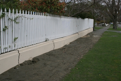
Cracks in a fence on a Residential property in Avonside, and liquefaction on the footpath, after the September 4th earthquake.

A large crack in the ground at Sullivan Park in Avonside which has resulted from the 4 September 2010 earthquake.

A footpath on Galbraith Avenue in Avonside showing cracking from the 4 September 2010 earthquake. Behind it, Sullivan Park can be seen.

A photograph of the earthquake damage the brick fence of a house in Christchurch. Bricks from the broken fence have been stacked on the footpath in front. Liquefaction has been piled on the footpath and road cones placed in front.