
A crack next to the Avon River caused by the ground slumping after the 4 September earthquake. A blue pipe has been laid over the crack. Many kilometres of these temporary water pipes have been run overground in Avonside to supply houses with water.

A photograph of road damage in Queensbury Street. The photographer says, "Many of the road disturbances are along the curb side requiring fill to level them".

Flooding along Avonside Drive. The power poles along the road are on an outward lean due to liquefaction at the base. Concrete blocks have been pushed up against them to keep them upright.

A photograph of the earthquake damage to the entrance of a property on Glenarm Street. The pavement has been churned up by the 4 September 2010 earthquake.

A photograph of the earthquake damage to St Paul's Church on Gayhurst Road. The tiles towards the back of the building have lifted.

A photograph of spring flowers in the garden of a residential property on Glenarm Street. Large cracks can bee seen in the soil.

A photograph of spring flowers in the garden of a residential property on Glenarm Street. Large cracks can bee seen in the soil.

A photograph of a walkway between two buildings of St Paul's School. A diagonal crack can be seen running between the bricks in one wall.

A photograph of the earthquake damage to the entrance of a property on Glenarm Street. The pavement has been churned up by the 4 September 2010 earthquake.

A photograph of the earthquake damage to St Paul's Church on Gayhurst Road. The tiles towards the back of the building have lifted.

Cracks along the footpath along Avonside Drive. In the distance workers are digging up the road. Road cones line the street and a "road closed" sign is visible.

A red-stickered house in Avonside. This means the house is unsafe to enter. A crack can be seen running through the lawn.
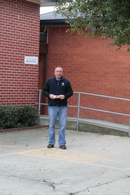
A photograph of Mark Osborne, a member of the Wellington Emergency Management Office, outside the office block of St Paul's School in Dallington.

Sullivan Park in Avonside. Liquefaction can be seen running across the park. Two signs have slumped towards each other. Blue pipes carrying a temporary water supply to the neighbourhood have been placed across the park.

The north end of the bridge on Gayhurst Road. During the earthquake, the bridge was forced about 15 centimetres towards the river, the land falling away under the road. Fencing has been placed around the footpath, and the road filled and resealed so that it can still be used by traffic.

A photograph of a portaloo outside a property on Gayhurst Road. Many parts of Christchurch were cut off from water after the September earthquake and had to use portaloos until the sewage system was fixed.

A photograph of a road cone in a crack in the footpath outside St Paul's School. In the background, volunteers from the Wellington Emergency Management Office are surveying the damage.

A photograph of cracks in Gayhurst Road near the intersection with Glenarm Terrace. Liquefaction can be seen on the street, and there is a road cone on a crack in the footpath.

Cracks along the road in Avonside Drive. The riverbank has slumped towards the river, separating the land from the road and creating these cracks. Road cones warn drivers of the uneven surface. In the distance, a pile of liquefaction can be seen in front of a house.

The driveway of a house on Avonside Drive. One of the concrete slabs has lifted and the owner has tried to fill the gap with blocks of wood. Unfortunately, these have come loose and are sticking out of the hole.

A photograph of liquefaction along the footpath in front of St Paul's Church on Gayhurst Road. The church was severely damaged during the 4 September earthquake. Tape has been placed around the building to warn people off.

A photograph of cracks running through the driveway of a residential property on Glenarm Terrace in Dallington. The cracks have been filled in with stones and planks of wood have been placed over them to allow the residents to continue using the driveway.

A photograph of volunteers from the Wellington Emergency Management Office standing outside St Paul's School on Gayhurst Road. There are cracks in the asphalt in front, and liquefaction on the ground.

A photograph of large cracks in the pavement in front of St Paul's School in Dallington. Liquefaction silt can also be seen. Police tape has been draped across the entrance of the building to the left.

A photograph of a cardboard sign outside St Paul's Church in Dallington. The sign reads, "St Paul's Parish Mass, Sunday 10am, Marian College Hall, North Parade". In the background police tape is draped around the building.

A photograph of the Wellington Emergency Management Office, taking photos of St Paul's Church in Dallington. The church was severely damaged after the 4 September earthquake. Police emergency tape can be seen around the building, keeping people away.

A photograph of the earthquake damage to the entrance of a driveway on Glenarm Terrace. A large hole in the foreground has had a road cone placed inside it. Other large cracks and liquefaction can bee seen. A man in overalls has parked his van next to the damage.

A photograph of the earthquake damage to St Paul's School in Dallington. Large cracks can be seen in the surface of the asphalt. Silt from liquefaction is visible in front of the school buildings. Tape has been placed on the building to keep people away.

A photograph of a sign outside St Paul's Parish on Gayhurst Road. The sign reads, "St Paul's Parish Mass, Sunday 10am, Marian College Hall, North Parade". The church was damaged during the 4 September earthquake. Tape can be seen around the building in the background.

A photograph of a house on Glenarm Terrace in Dallington. The chimney fell off the roof during the September earthquake and the bricks are still lying on the ground. A tarpaulin has been placed over the top of the hole to prevent water damage inside the house. Ironically, it has been weighed down with bricks.