
The RSA car park, Gloucester Street.

A residential property on Gloucester Street.

Photograph captioned by BeckerFraserPhotos, "Gloucester Street".

The intersection of Colombo and Gloucester Streets looking north-west.

The intersection of Colombo and Gloucester Streets looking south-west.

The Farmers building on Gloucester Street.

Winnie Bagoes on Gloucester Street. The side of the building has collapsed. Bricks and rubble lie in a pile on Gloucester Street where they fell.

The intersection of Colombo and Gloucester Streets looking north-east.

Photograph captioned by BeckerFraserPhotos, "Intersection of Gloucester and Manchester Streets (south-west view)".

Photograph captioned by BeckerFraserPhotos, "Intersection of Gloucester and Manchester Streets (west view)".

Photograph captioned by BeckerFraserPhotos, "Intersection of Gloucester and Manchester Streets (north-west view)".

Photograph captioned by BeckerFraserPhotos, "150 Gloucester Street".

Photograph captioned by BeckerFraserPhotos, "106 Gloucester Street".

Photograph captioned by BeckerFraserPhotos, "214 Manchester Street (view from Gloucester Street)".

Photograph captioned by BeckerFraserPhotos, "Gloucester/Manchester Street intersection (south-east corner)".

Photograph captioned by BeckerFraserPhotos, "Corner of Gloucester and Colombo Streets".

Photograph captioned by BeckerFraserPhotos, "The intersection of Manchester and Gloucester Streets looking south".

Shattered glass and boarded up windows on the corner of Colombo Street and Gloucester Street.

Photograph captioned by BeckerFraserPhotos, "The intersection of Colombo and Gloucester Streets, looking south down Colombo Street towards Cathedral Square. The soldiers are staffing the cordon as this is the main way through from one half of the central city red zone to the other half, which is now bisected by Gloucester Street".

Photograph captioned by BeckerFraserPhotos, "Corner of Gloucester Street and New Regent Street".

Posters in the windows above Mum's 24 cafe and restaurant on the corner of Colombo Street and Gloucester Street.

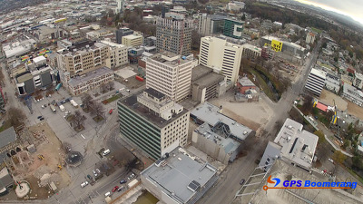
A snapshot from GPS Boomerang's SmartBird flight over the Christchurch red zone on 23 December 2012, looking over Gloucester Street with the Cathedral visible on the bottom left and Oxford Terrace to the right. Clarendon Towers has been demolished.
A snapshot from GPS Boomerang's SmartBird flight over the Christchurch red zone on 5 June 2012, looking over Gloucester Street with the Cathedral visible on the bottom left and Oxford Terrace to the right.

Christchurch CBD
New Zealand
31 August 2011

Christchurch CBD
New Zealand
31 August 2011

Christchurch CBD
New Zealand
31 August 2011

Thursday 5 April 2012.
File reference: CCL-2012-04-05-IMG_1118
From the collection of Christchurch City Libraries.

Tuesday 27 March 2012.
File reference: CCL-2012-03-27-IMG_0717
From the collection of Christchurch City Libraries.

Tuesday 27 March 2012.
File reference: CCL-2012-03-27-IMG_0718
From the collection of Christchurch City Libraries.

Tuesday 27 March 2012.
File reference: CCL-2012-03-27-IMG_0723
From the collection of Christchurch City Libraries.