Search
found 150 results
Image 2 - Territorial Force
Images, UC QuakeStudies
An image from a Army News March 2011 article titled, "Territorial Force". The image shows members of the Auckland and Northland Territorial Units clearing bricks from a resident's garden in east Christchurch.
Nisbet, Alistair, 1958- :Whitebait - how to spot the difference... 1 Septe…
Images, Alexander Turnbull Library
The cartoon is headed 'Whitebait - How to spot the difference.' Below are two frames; the one on the left shows a brown fish wearing goggles and breathing apparatus, it is from the East Coast and is described as 'drab brown' and 'tastes like dung'; the one on the right is pink and wears a sun hat and sunglasses, it is from the West Coast and is described as 'lightly tanned' and 'tastes like coconut'. Context: The whitebait from the east coast has been contaminated by the Canterbury earthquakes. Quantity: 1 digital cartoon(s).
Digital Photograph: Earthquake Damage to Road on Norwich Quay, Lyttelton
Images, Canterbury Museum
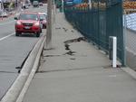
One landscape colour digital photograph taken on 25 February 2011 showing earthquake damage to the road, footpath and retaining wall on Norwich Quay. The photograph is taken from below the intersection of Norwich Quay and Canterbury Street looking east along Norwich Quay. Unlike most areas of Christchurch, land damage on the Port Hills was due ...

Digital Photograph: Demolition of the Dry Dock Pump House, Lyttelton
Images, Canterbury Museum
One landscape colour digital photograph taken on 22 March 2011 showing the demolition of the Dry Dock Pump House. Photograph taken from Brittan Terrace looking east over the Inner Harbour. Engineer The brick pump house for the Lyttelton Graving or Dry Dock was damaged in the 22 February 2011 Earthquake. Lyttelton Port of Christchurch decided to...
TJ's Kazbah, New Brighton After the Christchurch Earthquake
Images, UC QuakeStudies
Damage to TJ's Kazbah in New Brighton. The east and north walls and part of the upper floor have collapsed, tipping rubble and the contents of the rooms out onto the street. The photographer comments, "The occupants of the business and rooms all managed to escape alive. A digger was used to make the building safe and then used to sift through the rubble for any surviving belongings. It was a very emotional time for the ex-occupants".
Photograph by Neil Macbeth 338
Images, UC QuakeStudies
A collapsed section of road in north-east Christchurch. In the background, residents have piled liquefaction from their properties on the side of the road where it will be collected by road maintenance contractors.
Photograph by Neil Macbeth 339
Images, UC QuakeStudies
A collapsed section of road in north-east Christchurch. In the background, residents have piled liquefaction from their properties on the side of the road where it will be collected by road maintenance contractors.
Elizabeth Ackermann Photograph 349
Images, UC QuakeStudies
A photograph looking east down Gloucester Street, towards the intersection of Manchester Street. On-lookers are surveying earthquake damage from behind the cordon. The Christchurch City Council parking building can be seen in the distance.
Photograph by Neil Macbeth 326
Images, UC QuakeStudies
Liquefaction piled on the sides of a road in north-east Christchurch. The liquefaction has been dug out of the properties and piled on the side of the road to be collected by road maintenance contractors.
TJ's Kazbah, New Brighton After the Christchurch Earthquake (2)
Images, UC QuakeStudies
Damage to TJ's Kazbah in New Brighton. The east and north walls and part of the upper floor have collapsed, tipping rubble and the contents of the rooms out onto the street. The photographer comments, "The occupants of the business and rooms all managed to escape alive. A digger was used to make the building safe and then used to sift through the rubble for any surviving belongings. It was a very emotional time for the ex-occupants".
Digital Photograph: Earthquake Damage on Norwich Quay, Lyttelton
Images, Canterbury Museum
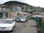
One landscape colour digital photograph taken on 25 February 2011 showing earthquake damage on Norwich Quay. The photograph is taken from approximately the intersection of Sutton and Norwich Quays looking east along Norwich Quay. The photograph also shows the eastern slope of Lyttelton and the damaged Timeball Station. Norwich Quay’s streetscap...
Cars Parked Near TJ's Kazbah During the Christchurch Earthquake
Images, UC QuakeStudies
Damage to TJ's Kazbah in New Brighton. The tower and east end of the building have collapsed onto two parked cars. The photographer comments, "The occupants of the business and rooms all managed to escape alive. A digger was used to make the building safe and then used to sift through the rubble for any surviving belongings. It was a very emotional time for the ex-occupants. The damaged cars were removed before the digger demolished the building".
Digital Photograph: Earthquake Damage to Lyttelton Roman Catholic and Diss…
Images, Canterbury Museum
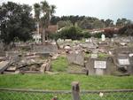
One landscape colour digital photograph taken on 30 June 2011 showing earthquake damage to graves in Lyttelton Roman Catholic and Dissenters (Public) Cemeteries in Reserve Terrace. Most of the headstones and grave surrounds in the photograph show damage. Looking east in the Dissenters (Public) section of the cemetery. The Lyttelton cemeteries a...

Digital Photograph: Earthquake Damage to Lyttelton Roman Catholic and Diss…
Images, Canterbury Museum
One landscape colour digital photograph taken on 30 June 2011 showing signs warning of the danger posed by unstable headstones in Lyttelton Roman Catholic and Dissenters (Public) Cemeteries in Reserve Terrace. Several toppled headstones and collapsed grave surrounds are visible in the photograph. Looking east from the main gate. The Lyttelton c...
Image 4 - Territorial Force
Images, UC QuakeStudies
An image from a Army News March 2011 article titled, "Territorial Force". The image shows members of the Auckland and Northland Territorial Units clearing silt from a resident's garden in east Christchurch. The resident is out in the garden helping out.
Photograph by Neil Macbeth 324
Images, UC QuakeStudies
A Transfield Services worker entering a manhole in north-east Christchurch. Piles of liquefaction are around the man hole. In the background, is one of the portable toilets set up after the 22 February 2011 earthquake to service areas of the city without operational sewers.
Roger Sutton/Man About Town Photograph 4
Images, UC QuakeStudies
A photograph of a paste-up from the Roger Sutton/Man About Town series, created by Nathan Ingram and Jemma Brown. The paste-up is titled "Love Man", and is on the east side of the Victoria Mansions building.
Nisbet, Alastair, 1958- :Meanwhile, on the other side of Mars... "Solid gr…
Images, Alexander Turnbull Library
A container labelled 'Chch East residents' has landed on the far side of the planet Mars. Others have landed or are descending. People in space suits exit the containers. One of them shakes hands with a green Martian commenting to him that the ground there is solid, it has nice views and "... the locals are a lot less alien than the insurance agents back home". Cartoon published when NASA's Curiosity rover landed on Mars on 5 August 2012. At this time there there was public debate over insurance claims by earthquake survivors in Christchurch's eastern suburbs. Title taken from item. Quantity: 1 digital cartoon(s). Processing information: Record title, scope and contents and note fields were updated in June 2025 as part of reparative description work. Details available on request.
Photograph by Neil Macbeth 337
Images, UC QuakeStudies
An earthquake-damaged road in north-east Christchurch. The manhole in the centre of the road has risen and a road cone has been placed in the centre to warn road users. Residents have piled liquefaction from their properties on the side of the road where it will be collection by road maintenance contractors.
Roger Sutton/Man About Town Photograph 1
Images, UC QuakeStudies
A photograph of a paste-up from the Roger Sutton/Man About Town series, created by Nathan Ingram and Jemma Brown. The paste-up is titled "Best Man", and is on the Crichton Cobbers building on Fitzgerald Avenue.
Image 5 - Territorial Force
Images, UC QuakeStudies
An image from a Army News March 2011 article titled, "Territorial Force". The image shows members of the Central and Lower North Island Territorial Units clearing silt from a resident's garden in east Christchurch. On the left is Private Quentin Chat of Taranaki, and Corporal Samuel Hatcher of Wellington is on the right.
Brockie, Robert Ellison, 1932- :God at his computer. 17 June 2011
Images, Alexander Turnbull Library
The cartoon shows God sitting at his computer with an image of a devastated Christchurch on the screen. He is about to hit the 'smite' key. Text above reads 'God at his computer'. Context - Two more earthquakes rocked Christchurch on 13th June, following those of 4 September 2010 and 22 February 2011. The first magnitude 5.5 quake struck at 1pm, 10 kilometres east of Christchurch at Taylor's Mistake beach, at a depth of 11 kilometres, and sent people scrambling for cover. It was followed at 2.20pm by a more powerful magnitude 6 quake, centred 10 kilometres southeast of the city and 9km underground. Quantity: 1 digital cartoon(s).

Digital Photograph: Demolition of the Empire Hotel, London Street, Lyttelt…
Images, Canterbury Museum
One landscape colour digital photograph taken on 19 April 2011 showing the demolition of the Empire Hotel on London Street. The photograph shows the façade of the hotel supported by the framework installed to brace the building after the 4 September 2010 earthquake. A crane is being used to enable the east wall to be demolished by hand to avoid...
Safe Dust
Images, UC QuakeStudies
A digitally manipulated image of printer's type, spelling out "Safe Dust". The photographer comments, "After the September 2010 Christchurch earthquake liquefaction poured out of the ground mostly in the East of Christchurch. This silt, which was a form of sand was declared safe and would not harm gardens if it was spread around in moderation. After the February 2011 quake as a result of even more liquefaction and the sewers being ruptured, the liquefaction was declared as toxic. People clearing it up should wear a mask, boots and gloves especially when it had dried up and become dusty. This just so happens to be the words found on an old printing press".

20130622_7842_1D3-24 Disabled in more ways than one (Day 173/365)
Images, eqnz.chch.2010
One of many disabled carparks outside what used to be one of the great sporting complexes in New Zealand. The Queen Elizabeth II Park complex in north-east Christchurch was built initially for the 1974 Commonwealth Games and was used for track and field and the adjoining pool complex had swimming and diving. It was built on an area that was used...
Winter, Mark 1958- :More quACHES. 14 June 2011
Images, Alexander Turnbull Library
The cartoon consists of the words 'More quACHES' drawn with a stencil. Context - Two more earthquakes rocked Christchurch on 13th June, following those of 4 September 2010 and 22 February 2011. The first magnitude 5.5 quake struck at 1pm, 10 kilometres east of Christchurch at Taylor's Mistake beach, at a depth of 11 kilometres, and sent people scrambling for cover. It was followed at 2.20pm by a more powerful magnitude 6 quake, centred 10 kilometres southeast of the city and 9km underground. There is a wordplay on 'quakes' and 'aches'. Quantity: 1 digital cartoon(s).
Close the Schools and Build the Jails
Images, UC QuakeStudies
A protest sign painted on a fence shows a bulldozer labelled "Govt." driven by a woman (presumably representing Education Minister Hekia Parata) running over a sheep labelled "Chch schools", next to the words "Every time you close a school you have to build a jail - Mark Twain." The photographer comments, "Due to the earthquakes in Christchurch and parents leaving the area to give their children a quieter and more education friendly life a lot of the local schools especially in the East of Christchurch are to be closed or amalgamated. This was a decision by the government without consultation with any other authorities. Mark Twain actually said 'Every time you stop a school, you will have to build a jail'".
Too Big For Its Bridges
Images, UC QuakeStudies
An earthquake-damaged bridge, the approach to which has slumped. The photographer comments, "Due to lateral spread and the land slumping the road leading to this bridge has moved down greatly. Just imagine making the street lamps upright and how much that section of road would rise up at the end. When you go over bridges in the east side of Christchurch it is quite a climb up and a big drop down on the other side. The bridges in most cases coped very well, but not so the land leading to them".
Mark Lincoln Photograph 184
Images, UC QuakeStudies
A woman takes a photograph over the top of the cordon fence at the east end of Re:Start mall. The photographer comments, "The new temporary city mall has been open in Christchurch now for a week. Buildings damaged in the earthquake have been demolished and replaced with cargo containers to create a new, temporary, Cashel Mall. I visited the mall yesterday and was quite impressed with what they have done. The cargo containers have been nicely converted, brightly painted and smartly branded to create some good looking stores ... You'd think it would be strange to stand where my old office used to be and view these cargo-container-stores, but the reality was that it was so far removed from what used to be there that it was actually quite difficult to make the connection. It was only when straying to the attractive wooden boundary fences and peering over that you're suddenly taken back to the time running right up to, and shortly after, the earthquake".
Remembering the 22nd February 2011
Images, UC QuakeStudies
Graffiti on a wooden wall depicts a child pointing at a site across the street and reads "I remember when the Kazbah was over there." The photographer comments, "A local street artist has commemorated Christchurch's deadliest earthquake. The anniversary is tomorrow. Where the photograph was taken was the site of the Ozone Hotel, which has now gone as well. For some of us who live and work in the East of Christchurch the earthquake was not what happened in the City as we were almost unaware of it. We had no water, toilets and most of all no electricity for weeks. For myself petrol was low and with tales of all the petrol stations on our side of town being damaged we could not take the chance of venturing out on severely damaged roads to find no petrol and the possibility of not getting home. We walked around and saw the damage that was local to us. TJ's Kazbah was one that stood out. A building that had a beauty with its round tower standing proud and always looked well kept - it was now collapsed. Its tower, which was once pointing towards the sky was laying on its side. It had kept its shape, but had a lightning shaped crack through it. The one thing that kept us feeling almost normal through the coming weeks was The Press our daily paper still being delivered even though the Press building and staff had suffered so badly themselves.