
One white hard hat with a SCIRT logo at the front.

One orange High Viz vest with a SCIRT logo on the front.

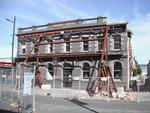
Canterbury Provincial Council and Supreme Court Buildings, Durham Street North.

Canterbury Provincial Council and Supreme Court Buildings, Durham Street North.

The September Canterbury earthquake. These pictures were taken of Colombo Street in Sydenham. A lot of masonry in this area has been damaged/fallen down.
Note: these photos were taken on a cellphone; mind the quality.

Photos taken in Lyttelton following the February 22 earthquake.
File ref: CCL-2011-03-05-After-The-Earthquake-P1110551
From the collection of Christchurch City Libraries

One landscape colour digital photograph taken on 19 November 2011 showing earthquake repairs being undertaken to the Irish Pub on the south side of London Street. The Lyttelton streetscape has changed dramatically from its pre-earthquake appearance and will continue to change as new buildings are erected on empty sections. In this photograph Lo...
One landscape colour digital photograph taken on 12 April 2011 showing earthquake damage to the Empire Hotel on London Street. The photograph shows the façade of the hotel supported by the framework installed to brace the building after the 4 September 2010 earthquake. Also visible on the fencing in the foreground is the advertising placard for...

One landscape colour digital photograph taken on 12 April 2011 showing earthquake damage to the Anglican Church of The Most Holy Trinity in Winchester Street Lyttelton. The photograph shows the bracing to the north transept which was erected after the 4 September 2010 earthquake. Architect After the 22 February 2011 earthquake the Church of the ...

One landscape colour digital photograph taken on 16 June 2011 showing the site of the Timeball Station after its collapse. Part of the ground floor remains visible. Photograph taken from Oxford Street Overbridge. Architect The 13 June 2011 earthquakes caused the collapse of the already damaged Lyttelton Timeball Station. After the 22 February ...

Earthquake damage at the Arts Centre, Christchurch

A view after the 7.1 magnitude earthquake in Christchurch.

Aftermath of September 4th Earthquake in Canterbury NZ. Bridge Street, South Brighton, Christchurch.

Aftermath of September 4th Earthquake in Canterbury NZ. Bridge Street, South Brighton, Christchurch.

The September Canterbury earthquake. These pictures were taken of Colombo Street in Sydenham. A lot of masonry in this area has been damaged/fallen down.
Monumental masons is a gravestone maker.
Note: these photos were taken on a cellphone; mind the quality.

The September Canterbury earthquake. These pictures were taken of Colombo Street in Sydenham. A lot of masonry in this area has been damaged/fallen down.
This was a headstone makers store.
Note: these photos were taken on a cellphone; mind the quality.

One framed certificate issued to SCIRT in 2013 to mark winning The Press Champion Canterbury Supreme Award in the Medium-Large Enterprise category.

A view after the 7.1 magnitude earthquake in Christchurch.

Aftermath of September 4th Earthquake in Canterbury NZ. Storm drains - Lower Styx Road, Brooklands.

One landscape colour digital photograph taken on 26 May 2013 showing the southern cliffs of Godley Head. Taken from the middle of the shipping channel. Some earthquake damage to the cliffs is visible. There were several major rock falls along the coastal cliffs near Christchurch and Lyttelton Harbour. At Godley Head these caused damage to the W...

One landscape colour digital photograph taken on 15 June 2011 showing earthquake damage to the Anglican Church of The Most Holy Trinity in Winchester Street, Lyttelton. Photograph shows collapsed roof of the nave and north transept. Photograph taken from the north side of the church. Architect The collapse of the Church of the Most Holy Trinity ...
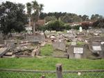
One landscape colour digital photograph taken on 30 June 2011 showing earthquake damage to graves in Lyttelton Roman Catholic and Dissenters (Public) Cemeteries in Reserve Terrace. Most of the headstones and grave surrounds in the photograph show damage. Looking east in the Dissenters (Public) section of the cemetery. The Lyttelton cemeteries a...

One landscape colour digital photograph taken on 30 June 2011 showing earthquake damage to a section of retaining wall in Sumner Road. Plastic sheeting installed to stabilise previous damage and protect from water erosion is visible to the right of the photograph. Also visible in the photograph is a boarded up broken window and temporary safety ...

One landscape colour digital photograph taken on 15 June 2011 showing earthquake damage to the Anglican Church of The Most Holy Trinity in Winchester Street, Lyttelton. Photograph shows collapsed roof of the nave and north transept. Photograph taken from the northwest corner of the church. Architect The collapse of the Church of the Most Holy Tr...

Photos taken in Lyttelton on March 20 following the February 22 earthquake.
File reference: CCL-2011-03-20-After-The-Earthquake-P1110736
From the collection of Christchurch City Libraries

One portrait colour digital photograph taken on 25 February 2011 showing earthquake damage to the Catholic Church of St Joseph the Worker in Winchester Street Lyttelton. Photograph shows the main doors and roof at southern end of church. Nineteenth century stone buildings are particularly vulnerable to earthquake damage as the individual compon...

A hardcover book that details in words and photographs the response of the New Zealand Army, Air Force and Navy to the 22 February 2011 earthquake.
Images from the Christchurch earthquake which struck on 22 February 2011

Aftermath of September 4th Earthquake in Canterbury, NZ. Damage to store - corner of Gloucester and Woodham Road, Christchurch.

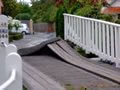
Telegraph Road was a straight road before the recent 7.1 magnitude earthquake. The fault ran right through here and now the road has a dramatic kink in it.