
Search
found 1533 results
Digital Photograph: Earthquake damage to St John's Church, Winchester Stre…
Images, Canterbury Museum
One landscape colour digital photograph taken on 25 February 2011 showing earthquake damage to the Presbyterian Church of St John in Winchester Street Lyttelton. Photograph shows the main doors, roof and collapsed tower at southern end of church. Architect St John's Lyttelton was one of the oldest Presbyterian Churches in Canterbury. The New Ze...

Digital Photograph: Earthquake damage to St John's Church, Winchester Stre…
Images, Canterbury Museum
One landscape colour digital photograph taken on 15 June 2011 showing earthquake damage to the Presbyterian Church of St John in Winchester Street, Lyttelton. Photograph shows the collapsed roof and tower. The photograph is taken from the southeast corner of the church. Architect St John's Lyttelton was one of the oldest Presbyterian Churches in...

wairoa street red zone
Images, eqnz.chch.2010
one of Christchurch's abandoned suburbs. The land moved - bricks and block walls everywhere collapsed - two multi story buildings folded - 184 people died. Wooden framed houses largely stayed up, many concrete slabs cracked, power poles leaned in liquid ground, surface bubbled, services ruptured .... damage to the cbd still gets the most cover...
IMG_2269
Images, eqnz.chch.2010
The farmer swore that his fence was erected in a straingt line, but mother nature had other ideas! Aftermath of the Saturday 4 September 2010 magnitude 7.1 earthquake at the previously unknown faultline along which the quake originated.

IMG_2268
Images, eqnz.chch.2010
The farmer swore that his hedge was planted in a straingt line, but mother nature had other ideas! Aftermath of the Saturday 4 September 2010 magnitude 7.1 earthquake at the previously unknown faultline along which the quake originated.

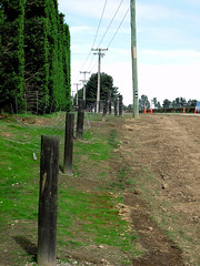
IMG_2270
Images, eqnz.chch.2010
The farmer swore that his fence was erected in a straingt line, but mother nature had other ideas! Aftermath of the Saturday 4 September 2010 magnitude 7.1 earthquake at the previously unknown faultline along which the quake originated.
New Zealand Defence Force photograph 718
Images, UC QuakeStudies
A member of the New Zealand Search and Rescue team outside damaged stores on Tuam Street. The top storeys of the stores have almost entirely collapsed onto the street, bringing the awnings down. A digger is parked on the street, and another one can be seen demolishing a store behind it.
Rebekah Rogers WEMO Photograph 072
Images, UC QuakeStudies
A photograph of the earthquake damage to the Registry Building on the corner of Montreal and Worcester Streets. Masonry around the gable has collapsed onto the footpath below. Steel bracing has been used to hold up the remaining masonry. Wire fencing has been placed around the building as a cordon.
Rebekah Rogers WEMO Photograph 071
Images, UC QuakeStudies
A photograph of the earthquake damage to the Registry Building on the corner of Montreal and Worcester Streets. Masonry around the gable has collapsed onto the footpath below. Steel bracing has been used to hold up the remaining masonry. Wire fencing has been placed around the building as a cordon.
WEMO ERT Set 1 - March 2011 - Photograph 44
Images, UC QuakeStudies
A photograph of a member of the New Zealand Army talking to a police officer on the corner of Colombo and Wordsworth Street. In the background there is a block of earthquake-damaged shops. Sections of the shops' walls have collapsed and the rubble has spilled onto the road and footpath.
WEMO ERT Set 2 - February 2011 - Photograph 07
Images, UC QuakeStudies
A photograph of the earthquake-damaged Cathedral of the Blessed Sacrament on Barbadoes Street. Rubble from the collapsed tower is lying on the ground in front. A car has been crushed under this rubble. Wire fencing, shipping containers, and road cones have been placed around the building as a cordon.
WEMO ERT Set 3 - February 2011 - Photograph 051
Images, UC QuakeStudies
A photograph of the earthquake-damaged Cathedral of the Blessed Sacrament on Barbadoes Street. Rubble from the collapsed tower is lying on the ground in front. A car has been crushed under this rubble. Wire fencing, shipping containers, and road cones have been placed around the building as a cordon.
WEMO ERT Set 3 - February 2011 - Photograph 052
Images, UC QuakeStudies
A photograph of the earthquake-damaged Cathedral of the Blessed Sacrament on Barbadoes Street. Rubble from the collapsed tower is lying on the ground in front. A car has been crushed under this rubble. Wire fencing, shipping containers, and road cones have been placed around the building as a cordon.
WEMO ERT Set 1 - March 2011 - Photograph 51
Images, UC QuakeStudies
A photograph of the earthquake damage to Knox Church on the corner of Bealey Avenue and Victoria Street. The brick walls of the gables have collapsed, exposing the building's wooden frame and the inside of the building. Wire fences and emergency tape have been placed around the building as a cordon.
WEMO ERT Set 1 - March 2011 - Photograph 50
Images, UC QuakeStudies
A photograph of the earthquake damage to the Piko Wholefoods Building on the corner of Kilmore and Barbadoes Street. Sections of the top storey of the building have collapsed and the bricks and other rubble have spilled onto the footpath below. Steel fences have been placed around the building as a cordon.

Digital Photograph: Earthquake Damage to Lyttelton Roman Catholic and Diss…
Images, Canterbury Museum
One landscape colour digital photograph taken on 30 June 2011 showing signs warning of the danger posed by unstable headstones in Lyttelton Roman Catholic and Dissenters (Public) Cemeteries in Reserve Terrace. Several toppled headstones and collapsed grave surrounds are visible in the photograph. Looking east from the main gate. The Lyttelton c...
Photograph by Neil Macbeth 266
Images, UC QuakeStudies
Smoke billowing from the remains of the collapsed Canterbury Television Building on Madras Street. Flames are visible through a gap in the intact section of the building. Below, emergency personnel can be seen searching the rubble for trapped people. On the right, two workers are using a piece of corrugated plastic as a slide to remove objects from the rubble.
Photograph by Neil Macbeth 281
Images, UC QuakeStudies
Emergency personnel searching for people trapped in the collapsed Canterbury Television Building on Madras Street. On the right, a man is using a sheet of corrugated plastic to slide pieces of debris off the building. Smoke is billowing from the remains of the building and a jet of water can be seen in the background, attempting to extinguish the fire.
UC Civil and Natural Resources Engineering Photograph 065
Images, UC QuakeStudies
A photograph of the earthquake damage to a group of shops on the corner of Barbadoes Street and Edgeware Road. The second storey of the shops has collapsed, and the bricks have fallen to the footpath, taking the awnings with them. Police tape and road cones have been placed around the buildings as a cordon.
UC Civil and Natural Resources Engineering Photograph 068
Images, UC QuakeStudies
A photograph of the earthquake damage to a group of shops on the corner of Barbadoes Street and Edgeware Road. The second storey of the shops has collapsed, and the bricks have fallen to the footpath, taking the awnings with them. Police tape and road cones have been placed around the buildings as a cordon.
Photograph by Neil Macbeth 161
Images, UC QuakeStudies
Members of the public speaking with police officers on the corner of Durham Street and Armagh Street in the aftermath of the 22 February earthquake. On the right the timber section of the historic Provincial Council Chambers can be seen, including the clock tower which has collapsed onto the road. Armagh Street leading into the city has been cordoned off by red tape.
Photograph by Neil Macbeth 271
Images, UC QuakeStudies
A member of the New Zealand Fire Service in a cherry picker spraying water at the fire burning in the collapsed Canterbury Television Building. Smoke is billowing out of the intact section of the building. Below, emergency personnel are searching the rubble for trapped people. A piece of corrugated plastic is being used to slide pieces of debris off the site.
Photographic Services Photograph 07
Images, UC QuakeStudies
A photograph of Graeme Kershaw, Technician at the University of Canterbury Department of Physics and Astronomy, scratching his head as he looks at the damaged clock drive of the Townsend Telescope. The telescope was damaged during the 22 February 2011 earthquake, when the Observatory tower at the Christchurch Arts Centre collapsed. Kershaw has been given the task of restoring the telescope.
Christchurch Press Image: Carys Monteath 2010:09:04 07:48:09
Images, UC QuakeStudies
Photograph captioned by Fairfax, "Christchurch Earthquake. A massive 7.4 magnitude earthquake has hit Christchurch and the wider South Island, causing widespread damage, two serious injuries and power cuts to most of the city. Marsha Witehira had the bricks from the wall of her house fall onto her bed where she was sleeping. Both sides of her house have collapsed".
Photograph by Neil Macbeth 646
Images, UC QuakeStudies
A view across Worcester Street in Linwood to a block of shops showing severe damage after the 22 February 2011 earthquake. The businesses include Talon Arms and Wick's Fish. Masonry and structural components from the buildings has collapsed onto the footpath and road. A sign in front of Talon Arms has been spray painted with the words, "Guns gone".
Photograph by Neil Macbeth 282
Images, UC QuakeStudies
Emergency personnel searching for people trapped in the collapsed Canterbury Television Building on Madras Street. On the right, a man is using a sheet of corrugated plastic to slide pieces of debris off the building. Smoke is billowing from the remains of the building and a jet of water can be seen in the background, attempting to extinguish the fire.
Observatory Tower Photograph 22
Images, UC QuakeStudies
A photograph of the base of the Townsend Telescope, still attached to a piece of rubble. The rubble is from the Observatory tower at the Christchurch Arts Centre. The tower collapsed during the 22 February 2011 earthquake and the rubble spilled into the courtyard in front. A digger was used to clear the rubble away from the building.
Observatory Tower Photograph 09
Images, UC QuakeStudies
A photograph of staff from the Department of Physics and Astronomy from the University of Canterbury recovering parts of the Townsend Telescope from the rubble of the Observatory tower. The telescope was housed in the tower at the Christchurch Arts Centre. It was severely damaged when the tower collapsed during the 22 February 2011 earthquake.
Observatory Tower Photograph 10
Images, UC QuakeStudies
A photograph of staff from the Department of Physics and Astronomy from the University of Canterbury recovering parts of the Townsend Telescope from the rubble of the Observatory tower. The telescope was housed in the tower at the Christchurch Arts Centre. It was severely damaged when the tower collapsed during the 22 February 2011 earthquake.
WEMO ERT Set 1 - March 2011 - Photograph 53
Images, UC QuakeStudies
A photograph of the earthquake damage to the John Burns & Co. Ltd building on Lichfield Street. The top section of the side wall has collapsed and the bricks have spilled onto the car park below, exposing the inside of the building. Several crushed cars have been removed from the car park and stacked on the street.