Search
found 1533 results
WEMO ERT Set 1 - March 2011 - Photograph 49
Images, UC QuakeStudies
A photograph of the earthquake damage to a building on the corner of Armagh and Barbadoes Streets. The outer walls of the building have collapsed and the bricks have spilled onto the footpath and road below. Steel and wire fences have been placed around the building as a cordon.

Wristband: Bands 4 Hope
Images, Canterbury Museum
One black wristband with the words ‘Band 4 Hope’ machine inscribed. These wristbands were designed as a fundraiser following the 22 February 2011 earthquake. This wristband was left as a tribute at the Canterbury Television (CTV) building which collapsed during the 22 February 2011 earthquake killing 115 people. It is one of three identical bla...

Wristband: Bands 4 Hope
Images, Canterbury Museum
One red wristband with the words ‘Band 4 Hope’ machine inscribed. These wristbands were designed as a fundraiser following the 22 February 2011 earthquake. This wristband was left as a tribute at the Canterbury Television (CTV) building which collapsed during the 22 February 2011 earthquake killing 115 people. It is the only red wristband left ...

IMG_2399
Images, eqnz.chch.2010
Steel frames are being used to shore the unstable facade of the St John the Baptist Church at Latimer Square while the building is being repaired and strengthened following the magnitude 7.1 earthquake that struck Christchurch on Saturday 4 September 2010.

IMG_2271
Images, eqnz.chch.2010
Hehehe ..... did the surveyors get the road setout wrong? This previously straight road is now kinked across this previously unknown faultline along which the Saturday 4 September 2010 magnitude 7.1 earthquake originated.

IMG_2272
Images, eqnz.chch.2010
Hehehe ..... did the surveyors get the road setout wrong? This previously straight road is now kinked across this previously unknown faultline along which the Saturday 4 September 2010 magnitude 7.1 earthquake originated.

IMG_2274
Images, eqnz.chch.2010
The farmers in this area swore that this road was straight when they were returning from the pub on Friday 3 September 2010, the night before the magnitude 7.1 earthquake struck.

IMG_2273
Images, eqnz.chch.2010
The farmers in this area swore that this road was straight when they were returning from the pub on Friday 3 September 2010, the night before the magnitude 7.1 earthquake struck.
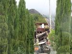
TJs Kazbah, 1 Bowhill Road, New Brighton Before the Christchurch Earthquake
Images, UC QuakeStudies
A photograph of TJ's Kasbah in North New Brighton, taken before the February 2011 earthquake. The photographer comments, "Here is what 1 Bowhill Road looked like before the Christchurch earthquake. It was called the Ozone store, which originally was incorporated in the blue Ozone building on the other side of the road".

IMG_2395
Images, eqnz.chch.2010
Cracks have ripped through external columns of this 7 storey building (corner of Hereford Street / Manchester Street), and efforts are being made to shore up and strengthen it to save it from demolition after it suffered structural damage in the magnitude 7.1 earthquake that struck Christchurch on Saturday 4 September 2010.

IMG_2396
Images, eqnz.chch.2010
Cracks have ripped through external columns of this 7 storey building (corner of Hereford Street / Manchester Street), and efforts are being made to shore up and strengthen it to save it from demolition after it suffered structural damage in the magnitude 7.1 earthquake that struck Christchurch on Saturday 4 September 2010.

IMG_2394
Images, eqnz.chch.2010
Cracks have ripped through external columns of this 7 storey building (corner of Hereford Street / Manchester Street), and efforts are being made to shore up and strengthen it to save it from demolition after it suffered structural damage in the magnitude 7.1 earthquake that struck Christchurch on Saturday 4 September 2010.
WEMO ERT Set 1 - March 2011 - Photograph 26
Images, UC QuakeStudies
A photograph of the earthquake damage to the Edward Gibbon building on Madras Street. Sections of the top storey have collapsed and the bricks have spilled onto the road in front, damaging the awning and smashing several cars. The message, 'Clear', has been spray-painted on the closest car.
WEMO ERT Set 1 - March 2011 - Photograph 37
Images, UC QuakeStudies
A photograph of the Stranges Building on the corner of High Street and Lichfield Street. In the background are the Mexican Café and Honey Pot Café buildings. The outer wall of the top storey of the Stranges Building has collapsed and the rubble has spilled onto the footpath below.
WEMO ERT Set 1 - March 2011 - Photograph 88
Images, UC QuakeStudies
A photograph of St Luke's Church on the corner of Manchester Street and Kilmore Street. Large sections of the church have collapsed and the masonry and other rubble have spilled onto the car park. Wire fences have been placed around the side of the building as a cordon.
WEMO ERT Set 1 - March 2011 - Photograph 115
Images, UC QuakeStudies
A photograph of a pile of twisted steel reinforcement and other rubble at the entrance to the Smiths City car park on Dundas Street. In the background a section of the collapsed car park has not been demolished yet. Many cars are still parked on the top floor.
I've Lit the Fuse, What Next?
Images, UC QuakeStudies
Two workers inspect fuses placed in an embankment during reinforcement work. The photographer comments, "This is the reinforcing of an embankment in the port of Lyttelton, which partly collapsed in the Christchurch earthquakes. They are using the same equipment as used for blowing up rock faces to mend them".
WEMO ERT Set 1 - March 2011 - Photograph 01
Images, UC QuakeStudies
A photograph of a member of the Wellington Emergency Management Office Emergency Response Team pointing to an earthquake-damaged house in central Christchurch. A large section of the house has collapsed, the rubble spilling onto the driveway. Emergency tape has been draped across the driveway as a cordon.
Image 2 - All in a Days Work
Images, UC QuakeStudies
An image from a Army News March 2011 photo compilation titled, "All in a Days Work". The image is captioned, "USAR workers sift through the crumbled ruins of a building". The building they are working on is the CTV building which collapsed during the 22 February 2011 earthquake.
New Zealand Defence Force photograph 055
Images, UC QuakeStudies
Damage to Christchurch city following the 22 February earthquake 2011. A collapsed building on the corner of Ferry Road and Lancaster Street. The brick walls of the building have crumbled, bringing the roof down with them. The wall of the building opposite has been exposed, and there is now a doorway to nowhere.
UC Civil and Natural Resources Engineering Photograph 069
Images, UC QuakeStudies
A photograph of the earthquake damage to a dairy on the corner of Barbadoes Street and Edgeware Road. The second storey of the dairy has collapsed, and the bricks have fallen onto the footpath, taking the awning with them. Police tape and road cones have been placed around the building as a cordon.
Photograph by Neil Macbeth 586
Images, UC QuakeStudies
A view across London Street in Lyttelton to The Volcano Cafe, The Lava Bar, and Coastal Living Design Store. Masonry from the buildings has collapsed onto the footpath, and the site has been cordoned off with wire fencing. The buildings' yellow recycling bins are still waiting on the curb for collection.
BeckerFraserPhotos March 2011 photograph 214
Images, UC QuakeStudies
A view down Cashel Street from the Bridge of Remembrance, showing earthquake damage to several buildings along Cashel Mall. In the background the Hotel Grand Chancellor can be seen, a Christchurch hotel that was badly damaged in the February 2011 earthquake. The collapse of a key supporting shear wall caused the building to visibly lean to one side.
Photograph by Neil Macbeth 166
Images, UC QuakeStudies
A view looking south down Durham Street. Two fire engines are driving north, and a pair of construction workers are walking up the road. Behind them is the damaged Provincial Council Legislative Chambers. The building's walls and roof have collapsed, as has the scaffolding which was erected to repair it after the 4 September 2010 earthquake.
Koen Broekema's Photograph 040
Images, UC QuakeStudies
The Wizard of Christchurch talks to a member of the public outside the damaged cathedral. A walkway from Gloucester Street to the Square was opened up for a few days to allow the public a closer look at the cathedral. The tower and the front wall of the building have partially collapsed. Steel bracing has been added to the front wall for support.
WEMO ERT Set 3 - February 2011 - Photograph 145
Images, UC QuakeStudies
A photograph of the earthquake damage to Charlie B's Backpackers on Madras Street. The front of the building has collapsed, the bricks and other rubble spilling onto the road and footpath in front. Many of the walls inside the top storey of the building are now hanging loose from the ceiling.
WEMO ERT Set 1 - March 2011 - Photograph 22
Images, UC QuakeStudies
A photograph of the back of two earthquake-damaged houses on Gloucester Street. The side wall of the house to the right has partially collapsed and the bricks have spilled onto the property to the left. Plastic sheeting has been placed over the roof and the top of the wall to protect against the weather.
Digital Photograph: Earthquake damage to the old Vicarage, Lyttelton
Images, Canterbury Museum
One landscape colour digital photograph taken on 25 February 2011 showing the damage to the former Anglican Vicarage on Ripon Street Lyttelton. Taken from the footpath. Architect The sense of loss felt when confronted with the collapse or demolition of an historic building is compounded when that building is also a home. While the community sees...