
Search
found 1910 results
Wounded
Images, eqnz.chch.2010
A magnitude 7.1 earthquake occurred at 4:35 am on September 4, 2010 here in Christchurch. There was damage and destruction to buildings but no loss of life. Five months later (22nd Feb, 2011) the city was struck by another quake. This time we weren't so lucky. 185 people lost their lives. Many people lost homes and businesses. The central b...

Canterbury Earthquake 7.1
Images, eqnz.chch.2010
Rolleston/Burnham, South Island, NZ It's been a busy few weeks! Was away on geology fieldtrips all the previous two weeks, then on Saturday morning 4th September 2010 at 4.35 am we got woken in Westport to a reasonable but very long earthquake. My husband was back in Christchurch at the time and texted me saying "are you ok?". I replied, "yes!"...

Medal: The Brunel Medal
Images, Canterbury Museum
One silver medal awarded to SCIRT in October 2013 from the Institution of Civil Engineers in the United Kingdom in recognition of the excellent in civil engineering. Includes storage case and explanation sheet.
Natalie Kerschner WEMO Photograph 049
Images, UC QuakeStudies
A photograph of a house on Worcester Boulevard, now a pile of rubble after the 4 September 2010 earthquake. Fire damage can be seen on the house next door.
Earthquake Contortions
Images, UC QuakeStudies
The badly twisted Medway Street footbridge. The photographer comments, "The September 4th 2010 earthquake in Christchurch was so violent that the banks of the Avon River moved towards each other. This footbridge being metal had to twist sideways to release the pressure of being pushed from both river banks. It looked like it had been wrung out like a wet towel".
BeckerFraserPhotos October 2010 photograph 071
Images, UC QuakeStudies
St Elmo Courts, a NZHPT heritage building on the corner of Hereford and Montreal Streets. The building was severely damaged during the 4 September earthquake, with diagonal cracking between the windows. Scaffolding has been placed around the bottom of the building.

Digital Photograph: Earthquake damage to the Lyttelton Timeball Station.
Images, Canterbury Museum
One landscape colour digital photograph taken on 16 June 2011 showing the eastern skyline of Lyttelton without the tower of the Timeball Station and Signal Mast. Part of the ground floor remains visible. The Holcim Cement Silos and Lyttelton Port of Christchurch log storage yard are visible in the foreground. Photograph taken from Oxford Street...

Digital Photograph: North side of London Street, Lyttelton
Images, Canterbury Museum
One landscape colour digital photograph taken on 19 November 2011 showing part of the north side of London Street. The properties visible in the photograph are (from left to right) Tommy Changs Café, Canterbury Street, site of theatre erected for the Loons Circus Theatre Company production of Macbeth (being dismantled), Lyttel Arthouse (closed),...

Digital Photograph: North side of London Street, Lyttelton
Images, Canterbury Museum
One landscape colour digital photograph taken on 19 November 2011 showing buildings on London Street. Visible in the photograph (left to right) are Bells Pharmacy - relocated into a converted house with law firm MacTodd on the upper floor, Portico (gift shop), Tommy Changs Cafe, and the edge of the Lyttelton Petanque Club Gap Filler initiative. ...

Digital Photograph: South side of London Street, Lyttelton
Images, Canterbury Museum
One landscape colour digital photograph taken on 19 November 2011 showing the alleyway next to 29 London Street. These steps provided access to the Wunderbar and the Monsta Bar (closed). Visible to the left is the Lyttelton Coffee Company building being repaired. Prior earthquake strengthening enabled the Lyttelton Coffee Company to undertake w...

Digital Photograph: Corner of London and Canterbury Streets, Lyttelton
Images, Canterbury Museum
One landscape colour digital photograph taken on 19 November 2011 showing the site of the Albion Hotel/ Ground Delicatessen. After the demolition of the building the site was used for a Gap Filler initiative called the Lyttelton Petanque Club. The photograph shows the temporary furniture, landscaping and public Petanque court. The site formerl...

Digital Photograph: North side of London Street, Lyttelton
Images, Canterbury Museum
One landscape colour digital photograph taken on 19 November 2011 showing part of the north side of London Street. The properties visible from left to right are Lyttel Piko Organic and Wholefoods, and Satchmo Café Pizzabar The Lyttelton streetscape has changed dramatically from its pre-earthquake appearance and will continue to change as new bu...

Digital Photograph: North side of London Street, Lyttelton
Images, Canterbury Museum
One landscape colour digital photograph taken on 19 November 2011 showing part of the north side of London Street. The properties visible from left to right are: Himalaya Design (obscured), Coffee Culture (downstairs), J Voyce and Co Ships Providore (upstairs), empty shop, and Lyttel Piko Organic and Wholefoods The Lyttelton streetscape has cha...

Digital Photograph: North side of London Street, Lyttelton
Images, Canterbury Museum
One landscape colour digital photograph taken on 19 November 2011 showing part of the north side of London Street. The properties visible from left to right are: part of Lyttel Piko Organic and Wholefoods, Satchmo Café Pizzabar, Milly May and Snoclothes New Zealand. The empty section was formerly occupied by No. 6 Cafe. The Lyttelton streetsc...

Digital Photograph: Irish Pub, south side of London Street, Lyttelton
Images, Canterbury Museum
One landscape colour digital photograph taken on 19 November 2011 showing earthquake repairs being undertaken to the Irish Pub on the south side of London Street. The Lyttelton streetscape has changed dramatically from its pre-earthquake appearance and will continue to change as new buildings are erected on empty sections. In this photograph Lo...

Digital Photograph: Census Poster in Window
Images, Canterbury Museum
One portrait colour digital photograph taken on 19 November 2011 showing a poster advertising the planned 2011 Census which was scheduled for Tuesday 8 March 2011. The census was abandoned because of the 22 February 2011 Earthquake. The poster was located in the window of the Lyttelton Information Centre on Oxford Street. The building was closed...

Digital Photograph: Lyttelton Coffee Company, London Street, Lyttelton
Images, Canterbury Museum
One portrait colour digital photograph taken on 19 November 2011 showing the framework of the Lyttelton Coffee Company Building surrounded by safety fencing. On the fencing are election hoardings and an advertisement for Samo, the café established by employees of the Lyttelton Coffee Company. Prior earthquake strengthening enabled the Lyttelton...

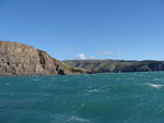
Digital Photograph: Godley Head Lighthouse
Images, Canterbury Museum
One landscape colour digital photograph taken on 26 May 2013 showing the Godley Head Lighthouse and cliffs. Taken from the entrance to Lyttelton Harbour looking north. The Godley Head Lighthouse (K4286) was discontinued on 6 July 2012. Volcanic banding is visible in the face of the cliffs. There were several major rock falls along the coastal ...

Digital Photograph: Godley Head
Images, Canterbury Museum
One landscape colour digital photograph taken on 26 May 2013 showing the southern cliffs of Godley Head, taken from the middle of the shipping channel. Some earthquake damage to the cliffs is visible. There were several major rock falls along the coastal cliffs near Christchurch and Lyttelton Harbour. At Godley Head these caused damage to the ...

Digital Photograph: Looking east from Norwich Quay, Lyttelton
Images, Canterbury Museum
One landscape colour digital photograph taken on 19 November 2011 looking east from Norwich Quay from approximately the base of Canterbury Street. Visible in the photograph are the partially deconstructed former Lyttelton Harbour Board Offices, the Holcim Cement Silos, the Oxford Street Railway Overbridge, Lyttelton Port of Christchurch's storag...

Digital Photograph: Shadbolt House, Norwich Quay, Lyttelton
Images, Canterbury Museum
One portrait colour digital photograph taken on 19 November 2011 showing Shadbolt House prior to its demolition. Architect Lyttelton's tallest building before its demolition was built in 1961 as the offices of the Lyttelton Harbour Board. At the time it was demolished the building was known as Shadbolt House and was owned by Independent Fisherie...

Digital Photograph: London and Oxford Streets
Images, Canterbury Museum
One landscape colour digital photograph taken on 27 May 2013 of London Street in Lyttelton. Taken from Sumner Road looking west across the intersection of London and Oxford Streets. The photograph shows several empty sections and the remaining buildings. The Lyttelton streetscape has changed dramatically from its pre-earthquake appearance and w...

Digital Photograph: Elevated view of London Street, Lyttelton
Images, Canterbury Museum
One landscape colour digital photograph taken on 26 May 2013 of London Street, Lyttelton. The photograph was taken from St Davids Street looking west. The roofs of the portable buildings forming the temporary Lyttelton Police station are visible in the foreground. The Lyttelton Port Company offices and Tunnel Portal are prominent in the midgrou...

Digital Photograph: Norwich Quay, Lyttelton.
Images, Canterbury Museum
One landscape colour digital photograph taken on 26 May 2013 on the corner of Norwich Quay and Canterbury Street, Lyttelton. The photograph shows the sites of the Royal Hotel, Shadbolt House, and the Lyttelton Hotel along Norwich Quay. The Wunderbar and the repair and strengthening work underway on the Lyttelton Working Mens Club/The Loons are v...
Digital Photograph: Godley Head, Lyttelton Harbour
Images, Canterbury Museum
One landscape colour digital photograph taken on 26 May 2013 off Godley Head looking north to Boulder Bay and Taylors Mistake. Rock which fell from the cliffs is heaped at the waters edge. Volcanic banding is visible in the face of the cliffs. There were several major rock falls along the coastal cliffs near Christchurch and Lyttelton Harbour....

Digital Photograph: Sumner Head
Images, Canterbury Museum
One landscape colour digital photograph taken on 26 May 2013 off Godley Head looking north towards Sumner Head. There were several major rock falls along the coastal cliffs near Christchurch and Lyttelton Harbour. In and around the suburb of Sumner some of these falls necessitated the abandonment of houses in areas where cliffs had given way or...

Digital Photograph: Earthquake damage to the Lyttelton Timeball Station.
Images, Canterbury Museum
One landscape colour digital photograph taken on 16 June 2011 showing the site of the Timeball Station after its collapse. Part of the ground floor remains visible. Photograph taken from Oxford Street Overbridge. Architect The 13 June 2011 earthquakes caused the collapse of the already damaged Lyttelton Timeball Station. After the 22 February ...
Could You Cycle Here?
Images, UC QuakeStudies
A cycle-lane sign submerged in water. The photographer comments, "During the Christchurch earthquake this sign must have dropped off of the pedestrian bridge above and landed straight down into the Avon River".
They Tried to Put Humpty Together Again
Images, UC QuakeStudies
A damaged brick building has wooden bracing holding the walls together. The photographer comments, "This building came through the September Christchurch quake with a few band aid plasters, but the February quake means that she is now DNR (Do Not Resuscitate)".
Open Plan Living and Good Indoor/Outdoor Flow
Images, UC QuakeStudies
A brick wall has fallen from this house, exposing the rooms within and leaving a pile of rubble in front. The ceiling has slumped and is held up with jacks. The photographer comments, "This was probably the result of the shallower February Christchurch earthquake rather than the bigger September one".