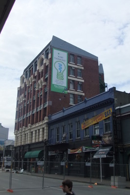
A photograph of the Treehouse Bar and Manchester Courts taken from the intersection of Manchester and Cashel Streets. Wire fencing has been placed across the street as a cordon.

A photograph of students at the University of Canterbury attending an earthquake memorial service on the C Block Lawn on the anniversary of the 22 February 2011 earthquake.

A photograph of students at the University of Canterbury attending an earthquake memorial service on the C Block Lawn on the anniversary of the 22 February 2011 earthquake.

A photograph of a flower in a road cone at the University of Canterbury. On the anniversary of the 22 February 2011 earthquake, people were encouraged to place flowers in road cones as a way of honouring those who lost their lives during the earthquake.

A photograph of a member of the public and a camera man standing in front of collapsed stores on Manchester Street taken shortly after the 22 February 2011 earthquake. An excavator can be seen in the background removing rubble.

A photograph of the back of the badly-damaged John Bull Cycles building on the corner of Colombo Street and Tuam Street.

A photograph of the back of the badly-damaged John Bull Cycles building on the corner of Colombo Street and Tuam Street.

A photograph of a cordon made out of temporary plastic fencing outside the Empire Hotel on London Street in Lyttelton.

A photograph of the Canterbury Provincial Chambers on Durham Street. The building has been cordoned off with wire fencing and the roof covered by plastic sheeting. A crane can be seen to the right.

A photograph of a truck on the site of the partially-demolished Art Gallery Apartments Building on Gloucester Street. In the background, an excavator is continuing to demolish the building.

A photograph of a worker evaluating the fallen ceiling tiles and pink batts in a teaching room at the University of Canterbury.

A photograph of fallen ceiling tiles and pink batts in a teaching room at the University of Canterbury.

A photograph of Rydges Hotel taken from behind a cordon fence on the Gloucester Street bridge near Cambridge Terrace.

A photograph of the Age Concern Canterbury Building behind a cordon fence on Cashel Street, near Cambridge Terrace. To the right is the site of a demolished building, next to another partially-deconstructed building.

A photograph of the site of the Crowne Plaza Hotel on the corner of Kilmore and Durham Streets. The hotel has been demolished, leaving large piles of rubble which two excavators are working to clear.

A photograph of two excavators demolishing the Manchester Securities House on the corner of Madras and Gloucester Streets.

A photograph of an excavator demolishing the Manchester Securities House on the corner of Madras and Gloucester Streets.

A photograph of the badly-damaged Edward Gibbon building on Tuam Street. The building has been cordoned off with wire fencing and the footpath behind the fence is covered in fallen bricks.

A photograph of a badly-damaged brick building on the corner of Madras Street and Lichfield Street. Lichfield Street has been cordoned off and fallen bricks lie behind a wire fence.

A photograph of a cordon at the entrance to Victoria Street from Bealey Avenue. Police tape and road cones have been placed across the street as well as a "Road Closed" sign.

A photograph of workers in a crane-raise platform removing bricks from the earthquake-damaged Christchurch Chinese Methodist Church on Papanui Road.

A photograph of workers from the Residential Access Project standing on High Street near the intersection with Tuam Street. In the background, a trailer is being loaded with items salvaged from people's homes during the project which gave residents temporary access to the cordon to retrieve items from their homes.

A photograph of workers loading a trailer with items salvaged from people's homes during the Residential Access Project. The project gave residents temporary access within the red-zone cordon in order to retrieve items from their homes.

A photograph of the west side of the of the ChristChurch Cathedral, and crowds of people in Cathedral Square. Scaffolding can be seen at the front of the Cathedral and The Chalice is in the distance.

A photograph of people walking through Press Lane, between Gloucester Street and Worcester Street. In the background, the Heritage Hotel can be seen.

A photograph of a camouflaged army vehicle on a road near Hagley Park.

A photograph of two workers loading a truck with items from people's homes during the Residential Access Project. The project gave residents temporary access within the red-zone cordon in order to retrieve items from their homes.

A photograph of trailers full of furniture and belongings from people's homes on Poplar Lane parked on High Street near the intersection with Tuam Street. The items were removed from the homes during the Residential Access Project which gave residents temporary access within the red-zone cordon in order to retrieve their possessions.

A photograph of an earthquake damaged building on the corner of Tuam and High Streets. The ground floor was the former site of C1 Espresso Cafe.

A photograph looking north down Manchester Street, taken from the intersection of Gloucester Street. In the distance, the road has been cordoned off. The Christchurch City Council car parking building can be seen on the right.