
Search
found 1309 results
Digital Photograph: Earthquake Damage to Old Post Office Building on Norwi…
Images, Canterbury Museum
One portrait colour digital photograph taken on 25 February 2011 showing damage to the Old Post Office Building on the Corner of Norwich Quay and Oxford Street. Architect The archaeological investigation of the site of the old Lyttelton Post Office uncovered evidence of Maori settlement in the area including a midden, fire places and an adze. Th...

Digital Photograph: Earthquake Damage to Lyttelton Historical Museum on Gl…
Images, Canterbury Museum
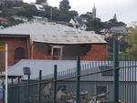
One landscape colour digital photograph taken on 25 February 2011 showing damage to the Lyttelton Historical Museum on the corner of Gladstone Quay and Donald Street. The photograph shows bracing and safety fencing installed after the September 2010 earthquakes. Architect Closed after the September 2010 earthquakes, the Lyttelton Museum buildin...
Digital Photograph: Earthquake Damage to Old Post Office Building on Norwi…
Images, Canterbury Museum
One landscape colour digital photograph taken on 27 April 2011 showing damage to the Old Post Office Building on the corner of Norwich Quay and Oxford Street. The old Telegraph office located beside the Old Post Office and the Timeball Station are also visible. Architect As Lyttelton's first main street, Norwich Quay was the site of many early g...
Digital Photograph: Sign Advertising a Matariki celebration in Lyttelton
Images, Canterbury Museum
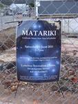
One portrait colour digital photograph taken on 8 June 2011 of a sign advertising Matariki Celebrations in Lyttelton. The sign is a printed piece of paper which has been laminated and attached to the fence on the site of the Volcano Restaurant on the corner of London and Canterbury Streets. The cleared site is visible through the fence in the ba...
Digital Photograph: Sign Advertising Whakahorohoro Ceremony in Lyttelton
Images, Canterbury Museum
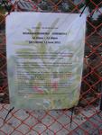
One portrait colour digital photograph taken on 8 June 2011 of a sign advertising a Whakahorohoro Ceremony in Lyttelton. The sign is a printed piece of paper which has been laminated and attached to the fence on the site of Ground Delicatessen on the corner of London and Canterbury Streets. The cleared site is visible through the fence in the ba...
Dan Neely WEMO Photograph 06
Images, UC QuakeStudies
A photograph of a block of damaged shops on the corner of Gloucester Street and Woodham Road. The top of the façade has crumbled. The bricks have fallen to the ground and taken the awnings with them. Wire fencing has been placed around the buildings as a cordon. Signs on the fences indicated that the T Bakery and Red Chilli are open.
Photograph by Neil Macbeth 069
Images, UC QuakeStudies
One end of the Arts Centre photographed shortly after the 22 February 2011 earthquake. The gable of the building has crumbled and fallen to the ground, collapsing an awning. A large crack can be seen in the corner tower. Blue ties can be seen at the top of the tower, used to brace the structure after the 4 September 2010. This has probably limited the damage caused by the 22 February 2011 earthquake.
Photograph by Neil Macbeth 091
Images, UC QuakeStudies
The damaged Cranmer Centre on the corner of Montreal and Armagh Streets shortly after the 22 February 2011 earthquake. The east wall of the building has crumbled onto the street and a man in a hard hat and high-visibility vest is directing people around it. There is scaffolding on the south side of the building from repair works after the 4 September 2010 earthquake. The gable in the background has also collapsed.
Photograph by Neil Macbeth 637
Images, UC QuakeStudies
The north-west end of the Arts Centre on the corner of Rolleston Avenue and Worcester Boulevard. The tip of the gable is missing as well as the spire which has been removed and braced on the footpath to limit damage. Wire fencing and road cones have been placed around the building as a cordon. In the distance, a crane is working on the building.
BeckerFraserPhotos April 2011 photograph 444
Images, UC QuakeStudies
Moira Fraser standing in front of the 'Passing Time' sculpture on the corner of St Asaph Street and Madras Street. 'Passing Time' was installed outside the CPIT Building for the 6th SCAPE (a contemporary public art programme in Christchurch) a few days prior to the 22 February 2011 earthquake. The work features twisting boxes depicting each year between 1906 (the founding of CPIT) and 2010 (the date of the sculpture's production).
BeckerFraserPhotos April 2011 photograph 397
Images, UC QuakeStudies
A plaque on the ground in front of the 'Passing Time' sculpture on the corner of Madras Street and St Asaph Street. The 'Passing Time' sculpture was installed outside the CPIT Building for the 6th SCAPE (a contemporary public art programme in Christchurch) a few days prior to the 22 February 2011 earthquake. The work features twisting boxes depicting each year between 1906 (the founding of CPIT) and 2010 (the date of the sculpture's production).
BeckerFraserPhotos April 2011 photograph 398
Images, UC QuakeStudies
Moira Fraser standing in front of the 'Passing Time' sculpture on the corner of St Asaph Street and Madras Street. 'Passing Time' was installed outside the CPIT Building for the 6th SCAPE (a contemporary public art programme in Christchurch) a few days prior to the 22 February 2011 earthquake. The work features twisting boxes depicting each year between 1906 (the founding of CPIT) and 2010 (the date of the sculpture's production).
BeckerFraserPhotos April 2011 photograph 401
Images, UC QuakeStudies
Moira Fraser in front of the 'Passing Time' sculpture on the corner of St Asaph Street and Madras Street. 'Passing Time' was installed outside the CPIT Building for the 6th SCAPE (a contemporary public art programme in Christchurch) a few days prior to the 22 February 2011 earthquake. The work features twisting boxes depicting each year between 1906 (the founding of CPIT) and 2010 (the date of the sculpture's production).
WEMO ERT Set 1 - March 2011 - Photograph 30
Images, UC QuakeStudies
A photograph of members of the Wellington Emergency Management Office Emergency Response Team working on the corner of Tuam and High Streets. In the background a large section of a building has collapsed and the bricks and other rubble have spilled onto the road. Wire fencing has been placed around the building as a cordon.
WEMO ERT Set 1 - February 2011 - Photograph 74
Images, UC QuakeStudies
A photograph of the entrance to the Brannigan's building on the corner of Gloucester Street and Oxford Terrace. Many of the windows down the centre of the building have broken, and the glass has fallen onto the footpath below. USAR codes have been spray painted on one of the front windows. A red sticker in the door indicates that the building is unsafe to enter.
Sonja Farmer Photograph 02
Images, UC QuakeStudies
A photograph of the earthquake damage to the Carlton Hotel on the corner of Bealey Avenue and Papanui Road. The walls along the western side of the building have crumbled, bricks spilling onto the footpath. Scaffolding and steel bracing has been erected up the side. Wire fencing has been placed around the building as a cordon. In the foreground, road cones line the street.
WEMO ERT Set 1 - March 2011 - Photograph 52
Images, UC QuakeStudies
A photograph of a building on the corner of Victoria Street and Bealey Avenue. Large sections of the building have collapsed and the bricks have spilled onto the footpath below. Scaffolding has been constructed around the rest of the building, blocking it from view. In the foreground steel fencing and road cones have been placed across Victoria Street as a cordon.
Rebekah Rogers WEMO Photograph 101
Images, UC QuakeStudies
A photograph of the earthquake damage to Knox Church on the corner of Bealey Avenue and Victoria Street. The walls of the gables have crumbled, the bricks falling onto the footpath. Many have been cleared away and now sit in a pile on the road. Road cones, metal fences, and cordon tape have been placed around the building.
Rebekah Rogers WEMO Photograph 052
Images, UC QuakeStudies
A photograph of the earthquake damage to the corner of Woodham Road and Avonside Drive. There are large cracks in the road, and flooding and liquefaction. Wire fencing and road cones have been placed around parts of the road that are unsafe. Two signs reading, "Road closed" and, "No entry" can be seen at the entrance to Avonside Drive.
WEMO ERT Set 1 - March 2011 - Photograph 148
Images, UC QuakeStudies
A photograph of the earthquake damage to St Paul's-Trinity-Pacific Church on the corner of Cashel and Madras Streets. Large sections of the church have collapsed and the bricks and other rubble have spilled onto the footpath and street in front. Sections of the scaffolding, constructed up the side of the building before the earthquake, have also collapsed.
WEMO ERT Set 3 - February 2011 - Photograph 044
Images, UC QuakeStudies
A photograph of an earthquake-damaged building on the corner of Colombo Street and St Asaph Street. The walls of the top storey of the building have crumbled, and bricks and other rubble have fallen onto the footpath and road below. In the background are many other earthquake-damaged buildings. Wire fencing and police tape have been placed across the street as a cordon.

Digital Photograph: Earthquake Damage to Lyttelton Historical Museum on Gl…
Images, Canterbury Museum
One landscape colour digital photograph taken on 14 July 2011 showing damage to the Lyttelton Historical Museum on the corner of Gladstone Quay and Donald Street. The photograph shows the safety fencing and containers installed after the 22 February 2011 earthquakes. Architect Closed after the September 2010 earthquakes, the Lyttelton Museum bu...
WEMO ERT Set 3 - February 2011 - Photograph 154
Images, UC QuakeStudies
A photograph of the earthquake damage to a building on the corner of Hereford and Madras Street. Sections of the façade have crumbled, bricks spilling onto the road in front. Wire fencing has been used to block off half of Madras Street. In the background, emergency management personnel are working through the rubble of the CTV building site. A digger and a crane are parked on the site.
WEMO ERT Set 3 - February 2011 - Photograph 221
Images, UC QuakeStudies
A photograph of the earthquake damage to the Iconic bar on the corner of Manchester and Gloucester Streets. Large sections of the outer walls have collapsed, the bricks and masonry spilling onto the footpath below, crushing several cars. USAR codes have been spray-painted near the door and a red sticker has been taped above. The red sticker indicates that the building is unsafe to enter.
WEMO ERT Set 1 - March 2011 - Photograph 98
Images, UC QuakeStudies
A photograph of the earthquake-damaged Our City O-Tautahi Building on the corner of Worcester Street and Oxford Terrace. Steel bracing has been placed against the building to secure the brick walls. The bracing is supported by large concrete blocks. Wire fences have also been placed around the bottom of the building as a cordon. Scaffolding has been erected around the tower to the right.
Rebekah Rogers WEMO Photograph 011
Images, UC QuakeStudies
A photograph of the earthquake damage to the Carlton Hotel on the corner of Papanui Road and Bealey Avenue. The wall of the top storey of the building has crumbled, and bricks have fallen onto the footpath. Wire fencing, road cones, and cordon tape have been placed around the building as a cordon. Scaffolding and steel bracing can be seen against the front of the building.

Digital Photograph: Earthquake Damage to Lyttelton Historical Museum, Glad…
Images, Canterbury Museum
One landscape colour digital photograph taken on 25 September 2011 showing the site of the Lyttelton Historical Museum on the corner of Gladstone Quay and Donald Street. The photograph shows the temporary fencing around the levelled site. The building visible at the rear is the former Municipal Stables on Donald Street. To the right of the phot...

Digital Photograph: Earthquake damage to Church of the Most Holy Trinity, …
Images, Canterbury Museum
One landscape colour digital photograph taken on 15 June 2011 showing earthquake damage to the Anglican Church of The Most Holy Trinity in Winchester Street, Lyttelton. Photograph shows collapsed roof of the nave and north transept. Photograph taken from the northwest corner of the church. Architect The collapse of the Church of the Most Holy Tr...
Walker, Malcolm, 1950- :Shhh! Urban planner at work... 8 July 2011
Images, Alexander Turnbull Library
The 11 frame cartoon strip tells a story about planning for a new Christchurch city post-earthquake. After filling the plan with every possible thing he can think of the planner puts the artist in an empty corner and the whole thing is delivered into a black hole that represents 'The real world'. Quantity: 1 digital cartoon(s).
WEMO ERT Set 1 - February 2011 - Photograph 19
Images, UC QuakeStudies
A photograph of the earthquake damage to the Country Theme store on the corner of Manchester and St Asaph Streets. Sections of the second storey walls have crumbled, and the bricks have fallen onto the footpath below. Wire fences have been placed around the building as a cordon. Red stickers on the front door and the wire fence indicate that the building is not safe to enter.