
Flooding and liquefaction on a residential property in Pines Beach, after the September 4th earthquake

A twisted bridge in Avonside blocked off with road cones after the September 4th earthquake.

An aerial photograph of the Port Hills following the 4 September earthquake, taken from a helicopter.

A twisted bridge in Avonside blocked off with road cones after the September 4th earthquake.

A crack in the centre of a street in Avonside after the September 4th earthquake.

An aerial photograph of the Port Hills following the 4 September earthquake, taken from a helicopter.

Photo of damage in Kaiapoi on tour with Hon Nick Smith, taken by Ian Heslop, 11 September 2010.
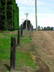
The farmer swore that his fence was erected in a straingt line, but mother nature had other ideas!
Aftermath of the Saturday 4 September 2010 magnitude 7.1 earthquake at the previously unknown faultline along which the quake originated.

The farmer swore that his hedge was planted in a straingt line, but mother nature had other ideas!
Aftermath of the Saturday 4 September 2010 magnitude 7.1 earthquake at the previously unknown faultline along which the quake originated.

The farmer swore that his fence was erected in a straingt line, but mother nature had other ideas!
Aftermath of the Saturday 4 September 2010 magnitude 7.1 earthquake at the previously unknown faultline along which the quake originated.

One white hard hat with a SCIRT logo at the front.

One orange High Viz vest with a SCIRT logo on the front.

A digitally manipulated image of a fallen headstone. The photographer comments, "Since the September 2010 earthquake in Christchurch, New Zealand a lot of the headstones have fallen, but sadly a lot have not been resurrected to their former places".

A photograph of Sumner and the Avon-Heathcote estuary taken prior to the 4 September 2010 earthquake. Shag Rock is visible near the centre of the photograph.

A photograph of Sumner and the Avon-Heathcote estuary taken prior to the 4 September 2010 earthquake. Shag Rock is visible near the centre of the photograph.
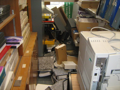
A photograph of a resource room in the Department of Civil and Natural Resources Engineering at the University of Canterbury after the 4 September 2010 earthquake.

The foundations of the historic Kaiapoi Railway Station building, which were damaged in the 4 September 2010 earthquake causing the building to lean towards the river.

A house on Avonside Drive with cracks in its foundations and the interior wall of its porch as a result of the 4 September 2010 earthquake.
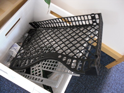
A photograph of broken filing trays in the rubbish at the Diabetes Centre on Hagley Avenue. The trays were damaged during the 4 September 2010 earthquake.

A photograph of a staff room in the Department of Civil and Natural Resources Engineering at the University of Canterbury after the 4 September 2010 earthquake.

A colour photograph of the Fisher's Building, seen from the corner of Lichfield and High Streets. The photograph was taken before the 4 September 2010 earthquake.

A photograph of emergency management personnel working in a temporary Civil Defence headquarters set up at the Mainland Foundation Ballpark after the 4 September 2010 earthquake.

A photograph of emergency management personnel working in a temporary Civil Defence headquarters set up at the Mainland Foundation Ballpark after the 4 September 2010 earthquake.

A photograph of a toppled bookcase in the Department of Civil and Natural Resources Engineering and the University of Canterbury after the 4 September 2010 earthquake.

One interactive model which demonstrates how different types of pipes perform in an earthquake.

The farmer swore that his fence and hedge were in a straingt line, but mother nature had other ideas!
Aftermath of the Saturday 4 September 2010 magnitude 7.1 earthquake at the previously unknown faultline along which the quake originated.

An aerial photograph of the port of Lyttelton following the 4 September earthquake, taken from a helicopter.

An aerial photograph of the port of Lyttelton following the 4 September earthquake, taken from a helicopter.

An aerial photograph of the port of Lyttelton following the 4 September earthquake, taken from a helicopter.

An aerial photograph of the port of Lyttelton following the 4 September earthquake, taken from a helicopter.