
One landscape colour digital photograph taken on 16 June 2011 showing the eastern skyline of Lyttelton without the tower of the Timeball Station and Signal Mast. Part of the ground floor remains visible. The Holcim Cement Silos and Lyttelton Port of Christchurch log storage yard are visible in the foreground. Photograph taken from Oxford Street...

Defence Force personnel walking down Norwich Quay during an operational tour of Lyttelton taken by Commander Joint Forces New Zealand, Air Vice Marshal Peter Stockwell and Chief of Army Tim Keating to view the aftermath of the Christchurch Earthquake. A large crack can be seen in the footpath.

An aerial view of the Port Hills a week after the 22 February 2011 earthquake. An army truck can be seen.

An aerial view of the Port Hills a week after the 22 February 2011 earthquake. A landslide on the hill can be seen.

Two workers inspect fuses placed in an embankment during reinforcement work. The photographer comments, "This is the reinforcing of an embankment in the port of Lyttelton, which partly collapsed in the Christchurch earthquakes. They are using the same equipment as used for blowing up rock faces to mend them".

Mayor Bob Parker shakes the hand of an officer on the HMNZS Otago during an onboard tour.

Mayor Bob Parker speaking to members of the ships' company from HMNZS Canterbury, HMNZS Otago and HMNZS Pukaki.

Mayor Bob Parker speaking to members of the ships' company from HMNZS Canterbury, HMNZS Otago and HMNZS Pukaki.

Mayor Bob Parker speaking to members of the ships' company from HMNZS Canterbury, HMNZS Otago and HMNZS Pukaki.

Mayor Bob Parker speaking to members of the ships' company from HMNZS Canterbury, HMNZS Otago and HMNZS Pukaki.

Mayor Bob Parker speaking to members of the ships' company from HMNZS Canterbury, HMNZS Otago and HMNZS Pukaki.

Mayor Bob Parker speaking to members of the ships' company from HMNZS Canterbury, HMNZS Otago and HMNZS Pukaki.

Mayor Bob Parker speaking to members of the ships' company from HMNZS Canterbury, HMNZS Otago and HMNZS Pukaki.

The magnitude 7.1 Christchurch earthquake broke off an enormous chunk of Castle Rock in the Port Hills which has tumbled down towards the Lyttelton tunnel.
View from Morgan's Valley (-43.578037° 172.714828°).

An image from a Navy Today April 2011 article titled, "Project Protector Makes a Difference". The image shows the HMNZS Pukaki, Otago and Canterbury alongside each other at the Lyttelton Port. The earthquake response was the first time one ship of each Project Protector class had been in a New Zealand port together (outside of the naval base).

A digitally manipulated photograph of broken windows on Shadbolt House. The photographer comments, "This was close to the start of the demolition of the earthquake damaged Shadbolt House building in the Port of Lyttelton, New Zealand. In the bright sun the glass reflected the blue sky, but the broken windows only reflected the blackness of the interior of the empty broken building".
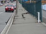
One landscape colour digital photograph taken on 25 February 2011 showing earthquake damage to the road, footpath and retaining wall on Norwich Quay. The photograph is taken from below the intersection of Norwich Quay and Canterbury Street looking east along Norwich Quay. Unlike most areas of Christchurch, land damage on the Port Hills was due ...

A blackboard announcing live music on Saturdays at the Lyttelton Petanque Club, a Gap Filler project in the empty site of the Ground Culinary Centre. In the distance, the Port Hole can be seen, a temporary bar made out of shipping containers where the Volcano Cafe used to be.