
A photograph of cracks in the ground near Governors Bay Road.

A photograph of cracks in the ground near Governors Bay Road.

A photograph of repaired cracks on Governors Bay Road.

A photograph of a crack in the concrete pad underneath a picnic table near Governors Bay Road.

A photograph of a concrete pad under a picnic table near Governors Bay Road. The concrete has shifted in the ground.

A photograph of cracks in the ground near Governors Bay Road.

A photograph of cracks in the ground near Governors Bay Road.

A photograph of repaired cracks on Governors Bay Road.

A photograph of cracks in the ground near Governors Bay Road.

A photograph of a picnic table near Governors Bay Road. The concrete pad underneath has cracked.

A photograph of repaired cracks on Governors Bay Road.

A photograph of a picnic table near Governors Bay Road. The concrete pad underneath has cracked.

A photograph of the cliff face along Wakefield Avenue in Sumner. It is showing signs of recent rockfall.

A photograph of the cliff face along Wakefield Avenue in Sumner. It is showing signs of recent rockfall.
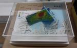
One oblong perspex covered 3-D model of the fault plains that ruptured to cause the 22 February and 13 June 2011 earthquakes; top of the model also acts as a map overlay. This model provides a visual demonstration of the geological forces that caused the 22 February and 13 June 2011 earthquakes. These forces were so strong that parts of the Por...

Photograph captioned by BeckerFraserPhotos, "Christchurch city from the air, looking south towards the Port Hills".

Houses in Lyttelton viewed from Reserve Terrace. The Port Hills are hidden by mist in the background.

Colombo Street looking south towards the Port Hills, taken from near the corner of Saint Asaph Street.

Aerial image of the Port Hills taken by the Royal New Zealand Air Force for the Earthquake Commission.

Aerial image of the Port Hills taken by the Royal New Zealand Air Force for the Earthquake Commission.

Aerial image of the Port Hills taken by the Royal New Zealand Air Force for the Earthquake Commission.

Aerial image of the Port Hills taken by the Royal New Zealand Air Force for the Earthquake Commission.

Aerial image of the Port Hills taken by the Royal New Zealand Air Force for the Earthquake Commission.

A view down High Street from Cashel Street, looking towards the Port Hills. Rubble from collapsed buildings litters the street.

An aerial view of the Port Hills a week after the 22 February 2011 earthquake. An army truck can be seen.

The electorate office of Ruth Dyson, Labour MP for Christchurch Port Hills. In the window is a "Keep calm and carry on" poster.

The electorate office of Ruth Dyson, Labour MP for Christchurch Port Hills. In the window is a "Keep calm and carry on" poster.

The magnitude 7.1 Christchurch earthquake broke off an enormous chunk of Castle Rock in the Port Hills which has tumbled down towards the Lyttelton tunnel.
View from Morgan's Valley (-43.578037° 172.714828°).

Photograph captioned by Fairfax, "Recently orphaned Paris Hilton, whose mother was killed by a falling boulder on a Port Hills farm, following the Canterbury earthquakes".

Photograph captioned by Fairfax, "Recently orphaned Paris Hilton, whose mother was killed by a falling boulder on a Port Hills farm, following the Canterbury earthquakes".