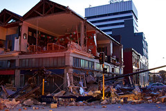
Helicopter Flight over Christchurch
New Zealand

A map showing road closures in the central city.

A map showing the locations of proposed developments in the central city.

None

None

None

None

A map showing areas of the central city where brothels will be allowed.

File Reference: CCL-CE-2013-09-30-EQNZ-2010.JPG
Photo taken by G. Coster
From the collection of Christchurch City Libraries

File Reference: CCL-CE-2013-09-30-EQNZ-2010.JPG
Photo taken by G. Coster
From the collection of Christchurch City Libraries

File Reference: CCL-CE-2013-09-30-EQNZ-2010.JPG
Photo taken by G. Coster
From the collection of Christchurch City Libraries

Another city walk around, this time with my brother-in-law from Auckland. Also went to the Quake City exhibition in the city organised by the Canterbury Museum. First fine day for a while.

Another city walk around, this time with my brother-in-law from Auckland. Also went to the Quake City exhibition in the city organised by the Canterbury Museum. First fine day for a while.

Another city walk around, this time with my brother-in-law from Auckland. Also went to the Quake City exhibition in the city organised by the Canterbury Museum. First fine day for a while.

Another city walk around, this time with my brother-in-law from Auckland. Also went to the Quake City exhibition in the city organised by the Canterbury Museum. First fine day for a while.

Another city walk around, this time with my brother-in-law from Auckland. Also went to the Quake City exhibition in the city organised by the Canterbury Museum. First fine day for a while.

None

Pigeons sit on the remains of one of the tallest buildings in Christchurch that was 95% demolished two or three years ago. The basement (now filled with water) and the columns remain.
Demolished due to damage from the Christchurch 2011 earthquake.

A map showing details of the Central City Plan.

A map showing road closures in the central city.

A map showing road closures in the central city.

File Reference: CCL-CE-2013-09-30-EQNZ-2010.JPG
Photo taken by G. Coster
From the collection of Christchurch City Libraries

6 March 2012.
File reference: CCL-2012-03-06-AroundChristchurch-IMG_0108
From the collection of Christchurch City Libraries.

6 March 2012.
File reference: CCL-2012-03-06-AroundChristchurch-IMG_0111
From the collection of Christchurch City Libraries.

6 March 2012.
File reference: CCL-2012-03-06-AroundChristchurch-IMG_0112
From the collection of Christchurch City Libraries.

A infographic giving the status of large buildings in the central city.

Hit at 4.35am (local time) on Saturday, September 4th 2010, measuring a 7.1 and centered 40km west of the city

Hit at 4.35am (local time) on Saturday, September 4th 2010, measuring a 7.1 and centered 40km west of the city

Hit at 4.35am (local time) on Saturday, September 4th 2010, measuring a 7.1 and centered 40km west of the city

Hit at 4.35am (local time) on Saturday, September 4th 2010, measuring a 7.1 and centered 40km west of the city
