
File Reference: CCL-CE-2010-09-08-DSC02048
From the collection of Christchurch City Libraries

A map showing areas of the central city where brothels will be allowed.

File Reference: CCL-CE-2013-09-30-EQNZ-2010.JPG
Photo taken by G. Coster
From the collection of Christchurch City Libraries

None

None

None

None

20131231_8484_EOS M-22 Quake City exhibit
Another city walk around, this time with my brother-in-law from Auckland. Also went to the Quake City exhibition in the city organised by the Canterbury Museum. First fine day for a while.
#4502
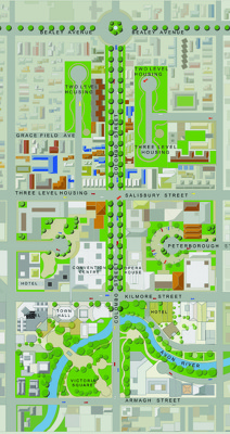
A map showing details of the Central City Plan.

A map showing road closures in the central city.

A map showing road closures in the central city.

File Reference: CCL-CE-2013-09-30-EQNZ-2010.JPG
Photo taken by G. Coster
From the collection of Christchurch City Libraries

File Reference: CCL-CE-2013-09-30-EQNZ-2010.JPG
Photo taken by G. Coster
From the collection of Christchurch City Libraries

File Reference: CCL-CE-2013-09-30-EQNZ-2010.JPG
Photo taken by G. Coster
From the collection of Christchurch City Libraries

Helicopter Flight over Christchurch
New Zealand

Another city walk around, this time with my brother-in-law from Auckland. Also went to the Quake City exhibition in the city organised by the Canterbury Museum. First fine day for a while.

A infographic giving the status of large buildings in the central city.

File Reference: CCL-CE-2013-09-30-EQNZ-2010.JPG
Photo taken by G. Coster
From the collection of Christchurch City Libraries
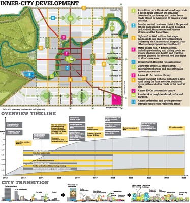
An infographic giving an overview of the draft Central City Plan.

A map showing the location of streams under the central city.

20131231_8503_EOS M-22 From Cashel Street
Another city walk around, this time with my brother-in-law from Auckland. Also went to the Quake City exhibition in the city organised by the Canterbury Museum. First fine day for a while.
#4504
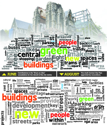
Word clouds comparing the draft Central City Plan to Share an Idea contributions.

An infographic showing retail floor size limits in the draft Central City Plan.

Hit at 4.35am (local time) on Saturday, September 4th 2010, measuring a 7.1 and centered 40km west of the city

Hit at 4.35am (local time) on Saturday, September 4th 2010, measuring a 7.1 and centered 40km west of the city

Hit at 4.35am (local time) on Saturday, September 4th 2010, measuring a 7.1 and centered 40km west of the city

Hit at 4.35am (local time) on Saturday, September 4th 2010, measuring a 7.1 and centered 40km west of the city

Hit at 4.35am (local time) on Saturday, September 4th 2010, measuring a 7.1 and centered 40km west of the city

6 March 2012.
File reference: CCL-2012-03-06-AroundChristchurch-IMG_0108
From the collection of Christchurch City Libraries.

6 March 2012.
File reference: CCL-2012-03-06-AroundChristchurch-IMG_0111
From the collection of Christchurch City Libraries.