
A photograph captioned by BeckerFraserPhotos, "A residential property on River Road".

A photograph captioned by BeckerFraserPhotos, "A residential property on River Road".

A photograph captioned by BeckerFraserPhotos, "A residential property on River Road".

Artificial flowers decorate a road cone on Estuary Road, New Brighton, on the anniversary of the 22 February 2011 earthquake.

A photograph of the earthquake damage to Rhodes Memorial Home on Dyers Pass Road.

A photograph of silt from liquefaction and a cracked footpath near a drain on Gayhurst Road.

A photograph captioned by BeckerFraserPhotos, "A residential property on River Road".

A photograph captioned by BeckerFraserPhotos, "Residential properties on River Road".

Power has been removed at these properties on New Brighton Road.

A photograph captioned by BeckerFraserPhotos, "A residential property on River Road".

A photograph captioned by BeckerFraserPhotos, "Liquefaction in New Brighton Road. Gumboots are essential for the photographer".

A photograph captioned by BeckerFraserPhotos, "A residential property on River Road".

A photograph captioned by BeckerFraserPhotos, "Even the sandbags look worse for wear in New Brighton Road".

A photograph captioned by BeckerFraserPhotos, "A residential property on River Road".

A photograph of the earthquake damage to Rhodes Memorial Home on Dyers Pass Road.

Workers and a police officer stand next to diggers and a Road Closed sign at the intersection of Victoria Street and Bealey Avenue, seen from Papanui Road.

A photograph captioned by BeckerFraserPhotos, "A residential property on River Road".

The Terrace on the Park apartment complex has been cordoned off. Fencing and road cones have been used to close the road around the complex.
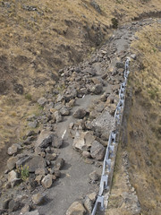
20130304_2852_G12-9 Rocks on Summit Road below Mt Cavendish

Christchurch Sept 4th Earthquake

A photograph looking north down Gayhurst Road, taken from the side of the bridge over the Avon River. Residential properties used to line the left-hand side of the road, and St Paul's church once stood on the corner. This was before the land was red-zoned as a result of the 2010 and 2011 Canterbury earthquakes. Separated cycle ways have recently been installed on both sides of the road. The photograph was modelled off an image taken by Mark Lincoln in September 2010.

A photograph looking north down Gayhurst Road, taken from the side of the bridge over the Avon River. Residential properties used to line the left-hand side of the road, and St Paul's church once stood on the corner. This was before the land was red-zoned as a result of the 2010 and 2011 Canterbury earthquakes. Separated cycle ways have recently been installed on both sides of the road. The photograph was modelled off an image taken by Mark Lincoln in September 2010.

A photograph looking north down Gayhurst Road, taken from the side of the bridge over the Avon River. Residential properties used to line the left-hand side of the road, and St Paul's church once stood on the corner. This was before the land was red-zoned as a result of the 2010 and 2011 Canterbury earthquakes. Separated cycle ways have recently been installed on both sides of the road. The photograph was modelled off an image taken by Mark Lincoln in September 2010.
Sadly the days are numbered after the 6.3 quake that hit Christchurch 22 February 2011! You can see the blue streel strengthening on the tower from the earthquake on 4 September 2010. Also if you look closely you can see the cracks that have determained its fate! Press L.

Flooding along Anzac Drive in Bexley. The photograph has been captioned by BeckerFraserPhotos, "Anzac Drive under reconstruction, adding about 40 cm to its elevation".

Art on the sides of shipping containers along Main Road in Sumner. The shipping containers have been placed along the road to protect road users from the risk of falling rocks from the cliff above. ContainerArt is a project to beautify shipping containers around the city, turning the negative into a positive.

A photograph looking west down Lichfield Street towards the intersection of Manchester Street. Bricks and other rubble from the earthquake-damaged buildings on either side of the road have scattered on the footpath and street. Road cones and plastic fencing has been used as cordons.

A large pile of liquefaction silt at a dump on Breezes Road. The photographer comments, "Breezes Road and Anzac Drive have recently opened but are now home to a brand new range of hills thanks to mountains of silt that have been collected by the hard working construction guys that have done a sterling job on the road there".

Art on the sides of shipping containers along Main Road in Sumner. The shipping containers have been placed along the road to protect road users from the risk of falling rocks from the cliff above. ContainerArt is a project to beautify shipping containers around the city, turning the negative into a positive.

Hehehe ..... did the surveyors get the road setout wrong?
This previously straight road is now kinked across this previously unknown faultline along which the Saturday 4 September 2010 magnitude 7.1 earthquake originated.