
A photograph of the earthquake damage to the Asko Design building on Victoria Street. The top of the facade has crumpled onto the street and awning below. A broken gutter and hole in the roof are visible to the left.

A photograph of the earthquake damage to a row of buildings on Colombo Street. The front of the buildings has collapsed, exposing the inside of both floors. The rubble from the collapsed walls has been cleared from the street in front.

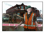
Photograph captioned by Fairfax, "Jade Kirk, a director of Jade/Roberts Consulting Engineers Ltd, was attacked by the operator of a 20-ton digger while trying to protect the earthquake-damaged Trinity Church on the corner of Worcester and Manchester Streets".
Oil and mixed media (ground up bricks and mortar and cordon tape) painting of an army woman (Private Rachel Crins of the 2nd Canterbury NMWC Battalion) behind a cordon restricting access to building damage from September 4, 2010 Canterbury earthquake.

Revisiting some of my images coming up to our one year anniversary of the 22 February 2011 Christchurch 6.3 earthquake.
Blue Jean Cuisine (Old Sydenham Post Office) built in 1911 was badly damaged in the 2011 earthquakes was demolished 2012.

20131212_6234_1D3-24 Another New Brighton building comes down (Day 346/365)
The old Esplanade Tavern is being demolished due to damage suffered in the earthquakes of 2011. Another one of New Brighton's iconic buildings to go.
#4457

Christchurch's CBD as seen from the Cashmere hills, south of the city.
Much of the CBD is still cordoned off and without power (as you should be able to spot) as a result of the damage caused by February's deadly earthquake.

Efforts are being made to shore up and strengthen this building (corner of Hereford Street / Manchester Street) to save it from demolition after it suffered structural damage in the magnitude 7.1 earthquake that struck Christchurch on Saturday 4 September 2010.

Efforts are being made to shore up and strengthen this building (corner of Hereford Street / Manchester Street) to save it from demolition after it suffered structural damage in the magnitude 7.1 earthquake that struck Christchurch on Saturday 4 September 2010.

Pigeons sit on the remains of one of the tallest buildings in Christchurch that was 95% demolished two or three years ago. The basement (now filled with water) and the columns remain.
Demolished due to damage from the Christchurch 2011 earthquake.

73 months after the earthquake that damaged it, the jetty at South New Brighton Domain is still not repaired. Seven years ago it was straight and level.
Dull, flat and orrible (horrible) light meant this image was destined to become monochrome!

A photograph captioned by BeckerFraserPhotos, "As we went by, we recorded the current state of the site of the urgent demolition in Redcliffs from last week. To our surprise when processing the photo, we noticed how damaged the surrounding houses are, particularly the house with the red tiles".

A photograph of the earthquake damage to Poplar Street taken from Tuam Street shortly after the 22 February 2011 earthquake. The road is completely covered by loose bricks and a car has been crushed. To the left, the corner of a building has collapsed, rubble falling into the street.

Crushed cars outside Winnie Bagoes on Gloucester Street. The cars were crushed when the top storey of Winnie Bagoes crumbled and fell into the street. A USAR code has been spray painted on one of the cars.

A photograph of the earthquake damage to Kudos Hairdressers on the corner of Papanui Road and Mansfield Avenue. The façade of the building has crumbled, the bricks falling to the footpath. Police tape has been draped around the building as a cordon.

A photograph of a woman walking past rubble from the earthquake damaged Cycle Trading store on Manchester Street shortly after the 22 February 2011 earthquake. A cars headlights can be seen through the rubble. The store's main window has been broken and the doors left open.

Damaged shops on Manchester Street. The front wall of the top storey of these buildings has crumbled onto the street, crushing vehicles. Emergency personnel have spray painted the word "Clear" on the cars to indicate that they have been checked for trapped or injured people.

Damaged shops on Manchester Street. The front wall of the top storey of these buildings has crumbled onto the street, crushing vehicles. Emergency personnel have spray painted the word "Clear" on the cars to indicate that they have been checked for trapped or injured people.

Damaged shops on Manchester Street. The front wall of the top storey of these buildings has crumbled onto the street, crushing vehicles. Emergency personnel have spray painted the word "Clear" on the cars to indicate that they have been checked for trapped or injured people.

The damaged Cranmer Courts on the corner of Kilmore and Montreal Streets. The corner of the building has crumbled onto the street, which is now littered with broken masonry. Wire fencing placed around the building after the 4 September 2010 earthquake has managed to keep the debris away from the road.

Photograph captioned by BeckerFraserPhotos, "96 Harbour Road, a red zoned property in Brooklands. Many of the homeowners in this area believe that their homes should not be red zoned as the damage is much less than in other red zoned areas".

A photograph of a fence on the Greendale Fault line which has been damaged by the 4 September 2010 earthquake. The wire has been pulled off the posts and is hanging loose. The ground has also shifted so the fence is no longer straight.

A photograph of a fence on the Greendale Fault line which has been damaged by the 4 September 2010 earthquake. The wire has been pulled off the posts and is hanging loose. The ground has also shifted so the fence is no longer straight.

A photograph of the Arts Centre taken from Rolleston Avenue near the Botanic Gardens. The building has been cordoned off by wire fencing and a wooden structure has been secured to the tower with tie-downs to help reduce damage from further aftershocks.

A photograph of the earthquake damage to The Press building in Cathedral Square. The top storey of the building has collapsed into the storey below, some of the masonry falling onto the pavement below. Wire fencing has been placed around the building as a cordon.

Photograph captioned by Fairfax, "A 1928 black and white film of Christchurch being played on a wall that is about to be demolished, on the site of South of the Border restaurant and Denis Moore Auto Electricians, which were destroyed by earthquake damage".

Photograph captioned by Fairfax, "A 1928 black and white film of Christchurch being played on a wall that is about to be demolished, on the site of South of the Border restaurant and Denis Moore Auto Electricians, which were destroyed by earthquake damage".

Extensive damage caused by liquefaction in Bracken Street, Avonside. A pile of liquefaction can be seen in front of this house. After the earthquake, many people had to dig this silt out of their properties and place it on the road to be collected.

Photograph captioned by Fairfax, "Christchurch Mayor Bob Parker surveys the earthquake damage to the Science Alive building (previously the old train station) on Moorhouse Avenue. The clock tower has large cracks and the clock itself stopped at the time the earthquake hit".

Photograph captioned by Fairfax, "Christchurch Mayor Bob Parker surveys the earthquake damage to the Science Alive building (previously the old train station) on Moorhouse Avenue. The clock tower has large cracks and the clock itself stopped at the time the earthquake hit".