Search
found 11195 results
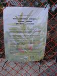
Digital Photograph: Sign Advertising Whakahorohoro Ceremony in Lyttelton
Images, Canterbury Museum
One portrait colour digital photograph taken on 8 June 2011 of a sign advertising a Whakahorohoro Ceremony in Lyttelton. The sign is a printed piece of paper which has been laminated and attached to the fence on the site of Ground Delicatessen on the corner of London and Canterbury Streets. The cleared site is visible through the fence in the ba...

Digital Photograph: Lyttelton Main School from the Gaol Steps, Lyttelton
Images, Canterbury Museum
One landscape colour digital photograph taken on 13 May 2011 showing Lyttelton Main School viewed from above near the top of the Gaol Steps between Oxford and St Davids Streets. The photograph is taken at an angle. Several subsequently demolished buildings are visible beyond the school including (from left to right) Lyttelton Police Station, th...

Digital Photograph: Gaol Steps and Lyttelton Main School, Oxford Street, L…
Images, Canterbury Museum
One landscape colour digital photograph taken on 13 May 2011 showing the damage to the Gaol Steps between Oxford and St Davids Streets and the upper playground of Lyttelton Main School. The Gaol Steps are a pedestrian link between Oxford and St Davids Streets. In October 2013 these steps were closed and barricaded with temporary fencing because...

Digital Photograph: The site of the Harbourlight Theatre, London Street, L…
Images, Canterbury Museum
One landscape colour digital photograph taken on 8 June 2011 showing the site of the Harbourlight Theatre on London Street. The site is fenced off, on the fence is the same heart shape which appears tied to a fence in a different part of London Street in 2013.17.39 A white painted wooden cross has been placed in the ground with 24 [street numbe...

Digital Photograph: Demolition of Former Canterbury Hotel, corner of Norwi…
Images, Canterbury Museum
One landscape colour digital photograph taken on 14 July 2011 showing the demolition of the former Canterbury Hotel on the corner of Norwich Quay and Oxford Street. At the time of demolition the ground floor was occupied by the Magma Gallery. Also visible in the photograph are the Old Post Office, Lyttelton Takeaways (corrugated iron walls) and ...

Digital Photograph: Partial demolition of the Old Lyttelton Harbour Board …
Images, Canterbury Museum
One landscape colour digital photograph taken on 19 May 2011 showing the partial demolition of the old Lyttelton Harbour Board Offices on the corner of Oxford Street and Norwich Quay. The photograph shows the upper floor of the original part of the building being removed and a temporary roof being constructed over the ground floor. At the time o...

Digital Photograph: Demolition of the former Library, Council Chambers and…
Images, Canterbury Museum
One landscape colour digital photograph taken on 11 June 2011 showing the demolition of the old Lyttelton Library, Council Chambers and Magistrates' Court on the corner of Oxford Street and Sumner Road. The photograph shows the upper floor of the building being demolished with a high reach digger and a jet of water being played on the building ...

Digital Photograph: Demolition of Former Canterbury Hotel, corner of Norwi…
Images, Canterbury Museum
One landscape colour digital photograph taken on 14 July 2011 showing the demolition of the former Canterbury Hotel on the corner of Norwich Quay and Oxford Street. At the time of demolition the ground floor was occupied by the Magma Gallery. Also visible in the photograph are 'Tin Palace' and a former office building which shows repairs made by...

Digital Photograph: Temporary Theatre, London Street, Lyttelton
Images, Canterbury Museum
One landscape colour digital photograph taken on 6 September 2011 showing the temporary theatre erected on the site of the Volcano Café on London Street for a production of Macbeth by The Loons Circus Theatre Company. The green canopy supported on shipping containers was used to shelter the audience. The stage area was the demolition site partia...

Sunset over a damaged city
Images, eqnz.chch.2010
Overlooking McCormacks bay out across the city with the Southern Alps as a backdrop. There is still a strong effect from the July 11, 2011 Volcanic erruption (Puyehue) in Chile. Ash made it over to New Zealand causing very strong colours at sunset. The colours have not been artificially changed and its not a mash up. The parts of the city (and...

St Pauls Church - other end of building subsided by about 50 cm
Images, eqnz.chch.2010
The base of the tower on the right of this picture has sunk about 25cm so that the lower course of bricks have disappeared below ground level. Meanwhile the other end of the building has sunk about 50cm splitting the building into thirds. The sand you can see is what came bubbling up out of the ground due to liquifaction. Unfortunately the build...

Sydenham Churchills Tavern - the black canopy under all those bricks is wh…
Images, eqnz.chch.2010
Reasons why it pays not to be a smoker - if the quake had hit during opening hours there would have been probably half a dozen smokers underneath the black awning crushed by falling bricks.

St Pauls school playground adjacent to church - that is not a wall at the …
Images, eqnz.chch.2010
The line that runs across this picture is the subsidence line - everything this side of the line has sunk by about 50 cm.

St Pauls Church - tower has subsided about 25cm
Images, eqnz.chch.2010
The base of the tower on the right of this picture has sunk about 25cm so that the lower course of bricks have disappeared below ground level. Meanwhile the other end of the building has sunk about 50cm splitting the building into thirds. The sand you can see is what came bubbling up out of the ground due to liquifaction. Unfortunately the build...

St Pauls church tower subsidence - first course of bricks no longer visible
Images, eqnz.chch.2010
The base of the tower on the right of this picture has sunk so that the lower course of bricks have disappeared below ground level. The sand you can see is what came bubbling up out of the ground due to liquifaction.

View from the back of the room
Images, eqnz.chch.2010
If you look very closely, running from the nearest right desk to the second desk on the left hand side, you can see my 'fault-line', - the crack that runs the length of the classroom under the lino.

St Pauls Church on Gayhurst Road Dallington
Images, eqnz.chch.2010
The base of the tower on the right of this picture has sunk about 25cm so that the lower course of bricks have disappeared below ground level. Meanwhile the other end of the building has sunk about 50cm splitting the building into thirds. The sand you can see is what came bubbling up out of the ground due to liquifaction. Unfortunately the build...

The end wall of this building collapsed onto the roof of the Monumental Ma…
Images, eqnz.chch.2010
Looked like a nice stereo they had.
Nisbet, Alistair, 1958- :Bottle Lake waste-dump recreation area?... 27 Nov…
Images, Alexander Turnbull Library
Several people run, leap, cycle and walk the dog through an area piled high with waste material. Context: Bottle Lake Forest Park has tracks and trails which include mountain-bike tracks, horse-trekking trails and walking tracks. After being established as a temporary dump after the February 22 earthquake the government intend to use special powers to turn part of Bottle Lake Forest Park into a permanent dump. Quantity: 1 digital cartoon(s).
Christchurch Press Image: Dean Kozanic 2010:09:10 (15)
Images, UC QuakeStudies
Photograph captioned by Fairfax, "Aftermath of the earthquake in Christchurch where the cleanup has begun. Teams of building inspectors gathered at the Linwood Service Centre before heading into the eastern suburbs en masse. Jeanette Banks, centre right, shares the relief of having had her property inspected with sister and Red Cross member Sandie Horne, down from Nelson. Napier building inspector, Gary Marshall, left, and City Council planner, Kent Wilson at right".
Christchurch Press Image: Dean Kozanic 2010:09:10 (12)
Images, UC QuakeStudies
Photograph captioned by Fairfax, "Aftermath of the earthquake in Christchurch where the cleanup has begun. Teams of building inspectors gathered at the Linwood Service Centre before heading into the eastern suburbs en masse. Napier building inspectors Gary Marshall, centre left, and Rod Jarvis were joined by City Council planner, Kent Wilson, right, and Kat Newman, left, who worked as the welfare officer on the team on Dallington Terrace".
Christchurch Press Image: Dean Kozanic 2010:09:10 (14)
Images, UC QuakeStudies
Photograph captioned by Fairfax, "Aftermath of the earthquake in Christchurch where the cleanup has begun. Teams of building inspectors gathered at the Linwood Service Centre before heading into the eastern suburbs en masse. Jeanette Banks, centre right, shares the relief of having had her property inspected with sister and Red Cross member Sandie Horne, down from Nelson. Napier building inspector, Gary Marshall, left, and City Council planner, Kent Wilson at right".

20160307_6607_7D2-110 Interior removal
Images, eqnz.chch.2010
The Forsyth Barr building has stood silent and empty (except the occasional intruder and pigeons) since the February 2011 earthquake. It was sold "as is" and I understand that it is now going to be fitted out as a hotel. This is the building that had severe stairwell damage during the quake necessitating people being lowered via ropes etc on t...
20130403_2911_G12-10 IRD building and 185 white chairs
Images, eqnz.chch.2010
Corner of Cashel and Madras streets, with the relatively new (built 2007) Inland Revenue Building and the white chair memorial to the 185 lives lost as a result of the 22/02/11 earthquake. The chairs sit on the site of the now demolished St Pauls Pacific Chuch and is diagonally across the intersection from the CTV (Canterbury TV) building where ...
New Zealand Defence Force photograph 665
Images, UC QuakeStudies
Members of the Singapore Civil Defence Force outside a tent in Latimer Square. After the 22 February 2011 earthquake, emergency service agencies set up their headquarters in Latimer Square.
Christchurch Press Image: Joseph Johnson 2010:09:08 09:26:47
Images, UC QuakeStudies
Photograph captioned by Fairfax, "Prime Minister John Key on his visit to Kaiapoi and Hororata to meet people badly affected and see the damage from the earthquake. Surveying Michael Oakley's knocked-over bins full of potatoes on his farm in Greendale, near Hororata, that suffered a lot of damage to produce".
Christchurch Press Image: Carys Monteath 2010:09:21 08:44:33
Images, UC QuakeStudies
Photograph captioned by Fairfax, "Gunyah homestead was badly damaged during the September 4th 2010 earthquake, but the Cotterill family are picking up the pieces and rebuilding. Builders repair the master bedroom where a large brick chimney came through the room narrowly missing the Cotterills and totally obliterating their bed".
Christchurch Press Image: Simonetta Cottrell 2010:09:04 09:22:19
Images, UC QuakeStudies
Photograph captioned by Fairfax, "Gunyah homestead was badly damaged during the September 4th 2010 earthquake, but the Cottrell family are picking up the pieces and rebuilding. Master bedroom where a large brick chimney fell through the roof crushing the bed where William and Simonetta Cottrell had been sleeping moments before".
Christchurch Press Image: Don Scott 2010:11:05 14:41:58
Images, UC QuakeStudies
Photograph captioned by Fairfax, "Pete Davey from Ambrose Heal Furniture. Owner Pete Davey has had to demolish his building and work out of a house at the back. He's going to rebuild, and has put a cheeky sign up saying that he has 'survived the recession, Chinese imports, and the earthquake'".
Christchurch Press Image: Carys Monteath 2010:09:21 08:44:22
Images, UC QuakeStudies
Photograph captioned by Fairfax, "Gunyah homestead was badly damaged during the September 4th 2010 earthquake, but the Cotterill family are picking up the pieces and rebuilding. Builders repair the master bedroom where a large brick chimney came through the room narrowly missing the Cotterills and totally obliterating their bed".