Search
found 1046 results
Umut Akguzel Photograph 506
Images, UC QuakeStudies
A photograph looking south down Manchester Street from the intersection with Hereford Street. Wire fencing has been placed along the right-hand side of the street as a cordon. To the left, the Treehouse Bar, Sullivans and Boogie Nights can be seen with rubble in front.
Digital Photograph: Earthquake Damage on Norwich Quay, Lyttelton
Images, Canterbury Museum
One landscape colour digital photograph taken on 25 February 2011 showing earthquake damage on Norwich Quay. The photograph is taken from approximately the intersection of Sutton and Norwich Quays looking east along Norwich Quay. The photograph also shows the eastern slope of Lyttelton and the damaged Timeball Station. Norwich Quay’s streetscap...
WEMO ERT Set 1 - February 2011 - Photograph 17
Images, UC QuakeStudies
A photograph of rubble from earthquake-damaged buildings along Colombo Street near the intersection with St Asaph Street. On the left-hand side of the street cars have been crushed by falling rubble. The road has been cordoned off with wire fencing.
WEMO ERT Set 1 - March 2011 - Photograph 35
Images, UC QuakeStudies
A photograph of High Street looking towards the intersection of Manchester and Lichfield Streets. Rubble from earthquake-damaged buildings litters the street to the right. In the distance excavators are clearing rubble from Manchester and High Streets while emergency management personnel look on.
WEMO ERT Set 3 - February 2011 - Photograph 170
Images, UC QuakeStudies
A photograph of a member of the Wellington Emergency Management Office Emergency Response Team standing on Hereford Street near the intersection of Manchester Street. In the background is the Hotel Grand Chancellor. The hotel has a noticeable slump on the left side.
Sonja Farmer Photograph 45
Images, UC QuakeStudies
A photograph of emergency personnel entering a cordon on Montreal Street near the intersection with Bealey Avenue. The cordon has been set up with road cones and a "Road closed" sign. Two members of the New Zealand Army are guarding the cordon.
WEMO ERT Set 2 - February 2011 - Photograph 18
Images, UC QuakeStudies
A photograph of emergency management personnel crossing the intersection of High, Colombo, and Hereford Streets. In the background is the earthquake-damaged Fisher's Building. Large sections of the top storey have collapsed, the masonry spilling onto the footpath and damaging the awning.
WEMO ERT Set 3 - February 2011 - Photograph 264
Images, UC QuakeStudies
A photograph of members of the Wellington Emergency Management Office walking down Gloucester Street towards the intersection of Manchester Street. Bricks from an earthquake-damaged building cover the footpath in the distance. Wire fences have been placed around the rubble as a cordon.
WEMO ERT Set 2 - February 2011 - Photograph 10
Images, UC QuakeStudies
A photograph taken from a corner of the Barbadoes and Worcester Streets intersection. On the opposite corner a brick building has collapsed, crushing three parked cars. To the right a rural fire van and a fire truck are parked on Worcester Street.
WEMO ERT Set 3 - February 2011 - Photograph 208
Images, UC QuakeStudies
A photograph of the Copthorne Hotel on the corner of Kilmore and Durham Streets. Tape has been draped around the footpath in front of the building. A member of the Wellington Emergency Management Office Emergency Response Team is walking through the intersection below.
Elizabeth Ackermann Photograph 201
Images, UC QuakeStudies
A photograph of trailers full of furniture and belongings from people's homes on Poplar Lane parked on High Street near the intersection with Tuam Street. The items were removed from the homes during the Residential Access Project which gave residents temporary access within the red-zone cordon in order to retrieve their possessions.
WEMO ERT Set 1 - March 2011 - Photograph 39
Images, UC QuakeStudies
A photograph looking west down Lichfield Street towards the intersection of Manchester Street. Bricks and other rubble from the earthquake-damaged buildings on either side of the road have scattered on the footpath and street. Road cones and plastic fencing has been used as cordons.
Christchurch Press Image: Dean Kozanic 2010:09:09 (01)
Images, UC QuakeStudies
Photograph captioned by Fairfax, "Aftermath of the earthquake in Christchurch where the cleanup has begun. USAR team members Mike Harvey, left, Craig Stevenson and Dr Jan Kupec, right, with Loss Adjustor Jonathan Winn from Cunningham Lindsey, centre right, work on Riccarton Road at the Rotherham Street intersection where several buildings were cordoned off".
Mark Lincoln Photograph 023
Images, UC QuakeStudies
Damaged buildings on Manchester Street, seen from the Tuam Street intersection. Police emergency tape cordons off the street. The photographer comments, "This was taken shortly after the 4th September earthquake. Police allowed us free access past the cordon and simply advised us to watch out for falling masonry. The access situation was much different after the February aftershock".
Bike Ride in the East Side - Photograph 60
Images, UC QuakeStudies
A sewage pumping station on Avonside Drive near the intersection with Robson Avenue has been lifted out of the ground by liquefaction. The photographer comments, "A Sunday afternoon ride to New Brighton, then back via Aranui, Wainoni, Dallington, and Richmond. Not a cheerful experience. Pumping station. Another hydraulically-lifted sewage pumping station, this time on Avonside Drive".
Ray Whelan WEMO Photograph 20
Images, UC QuakeStudies
A photograph of the site of a demolished building on Gloucester Street, near the intersection of Colombo Street. A Southern Demolition excavator is being used to clear the rubble away. In the background are the Forsyth Barr building, the Copthorne Hotel and the PricewaterhouseCoopers building.

Digital Photograph: Earthquake Damage and Demolition Work on London Street…
Images, Canterbury Museum
One landscape colour digital photograph taken on 27 April 2011 showing damage to London Street and demolition work being undertaken on the Harbourlight Theatre. Photograph taken looking west from the intersection of London Street with Oxford Street and Sumner Road. Architect In Christchurch's Central Business District many of the high profile d...
WEMO ERT Set 1 - March 2011 - Photograph 23
Images, UC QuakeStudies
A photograph looking north-west down High Street towards the intersection with Manchester Street. Rubble from several earthquake-damaged buildings lines both sides of the street. In the distance members of the Wellington Emergency Management Office Emergency Response Team and several excavators are working.
WEMO ERT Set 1 - March 2011 - Photograph 13
Images, UC QuakeStudies
A photograph of members of the Wellington Emergency Management Office Emergency Response Team standing on the intersection of Manchester and Lichfield Streets. In the background is the Majestic Theatre. Piles of rubble from earthquake-damaged buildings has been piled on the road below the building.
WEMO ERT Set 1 - March 2011 - Photograph 49
Images, UC QuakeStudies
A photograph of members of the Wellington Emergency Management Office walking down Lichfield Street towards the intersection of Madras Street. Buildings on either side of the team have been damaged by the earthquake and there are piles of rubble on the street in front of them.
BeckerFraserPhotos December 2011 photograph 0430
Images, UC QuakeStudies
An aerial photograph of the Christchurch central city looking over the Tuam and Durham Streets intersection. The photograph has been captioned by BeckerFraserPhotos, "Tuam Street is the most prominent street in this photograph. Durham Street runs across the foreground, and St Michael of all Angels is in the bottom right corner".
BeckerFraserPhotos December 2011 photograph 0402
Images, UC QuakeStudies
An aerial photograph of the Horseshoe Lake residential area near the Avon River. The photograph has been captioned by BeckerFraserPhotos, "Burwood School is at the top right of this photograph near the intersection of Lake Terrace Road and New Brighton Road. This area is mostly zoned residential green".
WEMO ERT Set 1 - March 2011 - Photograph 37
Images, UC QuakeStudies
A photograph of members of the Wellington Emergency Management Office Emergency Response Team walking down Lichfield Street towards the intersection of Manchester Street. Buildings on either side of the team have been damaged by the earthquake. Plastic and wire fences line the street to the right.
BeckerFraserPhotos December 2011 photograph 2319
Images, UC QuakeStudies
A photograph captioned by BeckerFraserPhotos, "Moira Fraser standing beside a bus stop sign in Bower Avenue (near the intersection with New Brighton Road) to demonstrate how much this pole has sunk into the ground. Note the marker with two round luminous spots which is at ground level and compare it with the next photo".
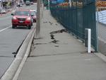
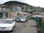
Digital Photograph: Earthquake Damage to Road on Norwich Quay, Lyttelton
Images, Canterbury Museum
One landscape colour digital photograph taken on 25 February 2011 showing earthquake damage to the road, footpath and retaining wall on Norwich Quay. The photograph is taken from below the intersection of Norwich Quay and Canterbury Street looking east along Norwich Quay. Unlike most areas of Christchurch, land damage on the Port Hills was due ...

Digital Photograph: Earthquake damage to the London Street Restaurant on L…
Images, Canterbury Museum
One landscape colour digital photograph taken on 27 April 2011 showing damage to the London Street Restaurant. Photograph taken looking west from the intersection of London Street with Oxford Street and Sumner Road. Adaptability and quick thinking has become a key part of business survival in post earthquake Canterbury. The owner of this bui...
WEMO ERT Set 1 - March 2011 - Photograph 51
Images, UC QuakeStudies
A photograph of members of the Wellington Emergency Management Office walking down Lichfield Street towards the intersection of Madras Street. Buildings on either side of the street have been damaged by the earthquake. Plastic fences have been places around piles of rubble on the street as cordons.
WEMO ERT Set 3 - February 2011 - Photograph 209
Images, UC QuakeStudies
A photograph of members of the Wellington Emergency Management Office walking down Kilmore Street near the intersection with Durham Street. To the left "no go" has been spray-painted on the Copthorne Hotel. A red sticker has been placed above this, indicating that the building is unsafe to enter.
WEMO ERT Set 3 - February 2011 - Photograph 105
Images, UC QuakeStudies
A photograph of a member of the Wellington Emergency Management Office Emergency Response Team walking through the intersection of Manchester and Gloucester Streets. In the background, Manchester Street has been cordoned off with wire fences and is littered with rubble. Many of the buildings in view are severely damaged.
Paul and Sam Corliss's Street Art Photograph (2015:03:24 04:08:30)
Images, UC QuakeStudies
A photograph of street art by the DTR crew between Aldwins Road and Linwood Avenue. The artwork depicts an orange cityscape behind purple tag art. The wall with the artwork on it is hidden behind billboards for Smart Real Estate and CPIT. A car is passing through an intersection in front of the artwork.