
One landscape colour digital photograph taken on 14 July 2011 showing damage to the Lyttelton Historical Museum on the corner of Gladstone Quay and Donald Street. The photograph shows the safety fencing and containers installed after the 22 February 2011 earthquakes. Architect Closed after the September 2010 earthquakes, the Lyttelton Museum bu...

A view after the 7.1 magnitude earthquake in Christchurch 4 September 2010.
Corner of Colombo and Byron Streets.
Given a bit of a HDR process to add some of what I was "feeling" at the time.

An advertisement for 'The Big Quake', a book about the 4 September earthquake produced by The Press. The advertisement advises that the book has sold out and is being reprinted.

Photo of damage to Waimakariri River South Branch(primary bank), taken by John Dore, 8 September 2010.

Photo of damage to mobiles shelves in Records Office, taken by Glenda Duffell on 6 September 2010.

A photograph of a sign in the Canterbury Quakes exhibition at the Canterbury Museum. The sign displays information about the 4 September 2010 earthquake.

A photograph of a section of road lying on the Greendale Fault line which has large cracks caused by the 4 September 2010 earthquake.
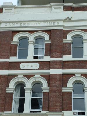
A colour photograph of details on the north side of the Lyttelton Times Building on Gloucester Street, taken after the 4 September 2010 earthquake.

The historic Kaiapoi Railway Station building, which can be seen leaning towards the river. Its foundations were damaged in the 4 September 2010 earthquake.

Bare patches of ground at Sullivan Park in Avonside. The bare patches mark where liquefaction covered the grass after the 4 September 2010 earthquake.

A house on Avonside Drive that has been abandoned due to damage from the 4 September 2010 earthquake. Its front garden has become overgrown.

A photograph of a building on Worcester Street which suffered fire damage when an electrical fire broke out after the 4 September 2010 earthquake.

A photograph of a fire fighter standing in front of 33 Worcester Street, now a pile of rubble after the 4 September 2010 earthquake.

A photograph of an opened filing cabinet at the Diabetes Centre on Hagley Avenue. The filing cabinet opened during the 4 September 2010 earthquake.

A photograph of an opened filing cabinet at the Diabetes Centre on Hagley Avenue. The filing cabinet opened during the 4 September 2010 earthquake.

A photograph of a displaced roof panel in the Diabetes Centre on Hagley Avenue. The panel was displaced during the 4 September 2010 earthquake.

A photograph of the Pills for Thrills building on Worcester Street which suffered damage from a fire caused by the 4 September 2010 earthquake.

An aerial photograph of rural Canterbury following the 4 September earthquake, taken from a helicopter.

An aerial photograph of rural Canterbury following the 4 September earthquake, taken from a helicopter.

An aerial photograph of rural Canterbury following the 4 September earthquake, taken from a helicopter.

An aerial photograph of rural Canterbury following the 4 September earthquake, taken from a helicopter.

An aerial photograph of rural Canterbury following the 4 September earthquake, taken from a helicopter.

An aerial photograph of rural Canterbury following the 4 September earthquake, taken from a helicopter.

An aerial photograph of rural Canterbury following the 4 September earthquake, taken from a helicopter.

An aerial photograph of rural Canterbury following the 4 September earthquake, taken from a helicopter.

An aerial photograph of rural Canterbury following the 4 September earthquake, taken from a helicopter.

An aerial photograph of rural Canterbury following the 4 September earthquake, taken from a helicopter.

An aerial photograph of rural Canterbury following the 4 September earthquake, taken from a helicopter.

An aerial photograph of rural Canterbury following the 4 September earthquake, taken from a helicopter.

An aerial photograph of rural Canterbury following the 4 September earthquake, taken from a helicopter.