Search
found 10153 results
Natalie Kerschner WEMO Photograph 008
Images, UC QuakeStudies
A photograph of a sign taped to the lamp post in front of Sonya Smith Atelier on Colombo Street. The sign reads, "Danger, keep out, restricted area". A yellow sticker on the front door also indicates that access to the building is restricted. A handwritten sign on the door reads, "Cannot open safely until structure is checked. Please ring Sonya if needing any more assistance. Sonya. Keep safe".
WEMO ERT Set 1 - March 2011 - Photograph 99
Images, UC QuakeStudies
A photograph looking west down Cashel Street from the intersection of Colombo Street. A member of the New Zealand Police is sitting on an armchair near the intersection. Behind him is a HireQuip generator. Several signs from nearby businesses are on his left and right. In the background there are large piles of rubble from earthquake-damaged buildings on the street.
Mark Lincoln Photograph 181
Images, UC QuakeStudies
Shoppers and tourists in the Re:Start mall. The photographer comments, "The new temporary city mall has been open in Christchurch now for a week. Buildings damaged in the earthquake have been demolished and replaced with cargo containers to create a new, temporary, Cashel Mall. I visited the mall yesterday and was quite impressed with what they have done. The cargo containers have been nicely converted, brightly painted and smartly branded to create some good looking stores".
Observatory Tower Photograph 32
Images, UC QuakeStudies
A photograph of the earthquake damage to the Observatory tower at the Christchurch Arts Centre. The top two storeys of the tower collapsed during the 22 February 2011 earthquake and the rubble spilled into the courtyard in front. A digger was used to clear the rubble away from the building. A tarpaulin has been draped over the top of the broken tower and the roof behind.
We Lived Here: Oxford Terrace Photograph 108
Images, UC QuakeStudies
A photograph of the house number spray-painted on the front of Robin Duff's house at 386 Oxford Terrace. To the right, two stickers have also been stuck to the door. The top sticker reads, "Attention, power has been removed". The bottom sticker is the Christchurch City Council's 'yellow sticker', which indicates that access to the building is restricted.
ELM Offices Level 7 Library - Photograph 01
Images, UC QuakeStudies
Members of the University of Canterbury's E-Learning team in their temporary office in the James Hight building. The photographer comments, "First looks at our new temporary (maybe) office space. Our group will stay here until April or May 2011, then will move to another floor in the Central Library. First briefing. Warren Marett, an acting manager from Deloittes (with tie), discusses our move with Electronic Learning Media staff; Alan Hoskin, Antoine Monti, Herbert Thomas, Paul Nicholls, and Jess Hollis".
ELM Offices Level 7 Library - Photograph 14
Images, UC QuakeStudies
Members of the University of Canterbury's E-Learning team admire the view from their temporary office in the James Hight building. The photographer comments, "First looks at our new temporary (maybe) office space. Our group will stay here until April or May 2011, then will move to another floor in the Central Library. South window of our office. Our view looks out to the Port Hills and around to the south west, towards Halswell and Lincoln".
ELM Offices Level 7 Library - Photograph 18
Images, UC QuakeStudies
Furniture and equipment packed up ready for the University of Canterbury's E-Learning team's move to their temporary office in the James Hight building. The photographer comments, "First looks at our new temporary (maybe) office space. Our group will stay here until April or May 2011, then will move to another floor in the Central Library. Waiting for the movers. Our office is packed into orange crates, everything is labelled, where are the movers?".

Digital Photograph: North side of London Street, Lyttelton
Images, Canterbury Museum
One landscape colour digital photograph taken on 19 November 2011 showing buildings on London Street. Visible in the photograph (left to right) are Bells Pharmacy - relocated into a converted house with law firm MacTodd on the upper floor, Portico (gift shop), Tommy Changs Cafe, and the edge of the Lyttelton Petanque Club Gap Filler initiative. ...

Digital Photograph: Census Poster in Window
Images, Canterbury Museum
One portrait colour digital photograph taken on 19 November 2011 showing a poster advertising the planned 2011 Census which was scheduled for Tuesday 8 March 2011. The census was abandoned because of the 22 February 2011 Earthquake. The poster was located in the window of the Lyttelton Information Centre on Oxford Street. The building was closed...

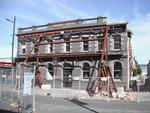
Digital Photograph: Demolition of the Royal Hotel, corner of Norwich Quay …
Images, Canterbury Museum
One landscape colour digital photograph taken on 27 April 2011 showing the demolition of the Royal Hotel on the corner of Norwich Quay and Canterbury Street. The hotel building shown in this photograph was the third on the site since 1851. It was built in 1916 as a replacement for the first Royal Hotel. The Royal Hotel was established in 1870 a...
Digital Photograph: Earthquake damage to the Empire Hotel, London Street, …
Images, Canterbury Museum
One landscape colour digital photograph taken on 12 April 2011 showing earthquake damage to the Empire Hotel on London Street. The photograph shows the façade of the hotel supported by the framework installed to brace the building after the 4 September 2010 earthquake. Also visible on the fencing in the foreground is the advertising placard for...

Digital Photograph: Demolition of the Empire Hotel, London Street, Lyttelt…
Images, Canterbury Museum
One landscape colour digital photograph taken on 19 April 2011 showing the demolition of the Empire Hotel on London Street. The photograph shows the façade of the hotel supported by the framework installed to brace the building after the 4 September 2010 earthquake. A crane is being used to enable the east wall to be demolished by hand to avoid...

Digital Photograph: Demolition of the former Library, Council Chambers and…
Images, Canterbury Museum
One landscape colour digital photograph taken on 11 June 2011 showing the demolition of the old Lyttelton Library, Council Chambers and Magistrates' Court on the corner of Oxford Street and Sumner Road. The photograph shows the upper floor of the building being demolished with a high reach digger. At the time of the 22 February 2011 Earthquake...

Digital Photograph: Partial demolition of the Old Lyttelton Harbour Board …
Images, Canterbury Museum
One landscape colour digital photograph taken on 19 May 2011 showing the partial demolition of the old Lyttelton Harbour Board Offices on the corner of Oxford Street and Norwich Quay. The photograph shows the upper floor of the original part of the building being removed and a temporary roof being constructed over the ground floor. At the time o...

Digital Photograph: Partial Demolition of the Old Lyttelton Harbour Board …
Images, Canterbury Museum
One landscape colour digital photograph taken on 16 June 2011 showing the partial demolition of the old Lyttelton Harbour Board Offices on the corner of Oxford Street and Norwich Quay. The photograph shows the temporary roof being constructed over the original ground floor of the building. At the time of the 22 February 2011 earthquake the build...
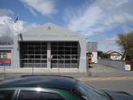
Digital Photograph: Lyttelton Fire Station, London Street, Lyttelton
Images, Canterbury Museum
One landscape colour digital photograph taken on 19 November 2011 showing the Lyttelton Fire Station. The building is fenced off and unused due to earthquake damage. To the right of the photograph the front of one of the Fire Appliances and the shipping containers set up in the rear car park to provide temporary facilities can be seen. Followin...

Digital Photograph: Corner of London and Oxford Streets, Lyttelton
Images, Canterbury Museum
One landscape colour digital photograph taken on 19 November 2011 showing the site of the old Lyttelton Library, Council Chambers and Magistrates' Court on the corner of Oxford Street and Sumner Road. At the time of the 22 February 2011 Earthquake the building was in private ownership and was the premises of Moda Fotografica and a private resid...

Digital Photograph: Earthquake Damage to Lyttelton Historical Museum, Glad…
Images, Canterbury Museum
One landscape colour digital photograph taken on 25 September 2011 showing the site of the Lyttelton Historical Museum on the corner of Gladstone Quay and Donald Street. The photograph shows the temporary fencing around the levelled site. The building visible at the rear is the former Municipal Stables on Donald Street. To the right of the phot...

Digital Photograph: Former Convent of Our Lady of Mercy, Exeter Street, an…
Images, Canterbury Museum
One landscape colour digital photograph taken on 30 June 2011 showing earthquake damage to the former Convent of Our Lady of Mercy and to the Catholic Church of St Joseph the Worker. Photograph taken from St. Davids Street The sense of loss felt when confronted with the collapse or demolition of an historic building is compounded when that bui...
Nisbet, Alistair, 1958- :New gateway for Christchurch?... 24 November 2011
Images, Alexander Turnbull Library
A new gateway into Christchurch is named 'Highway to hell'. Context: describes the way many Christchurch people feel about their city after the earthquakes of 2010 and 2011. There is a high level of frustration and feelings of helplessness brought about by uncertainty about the future because of building and insurance problems. Quantity: 1 digital cartoon(s).

20130207_2231_1D3-165 Sumner and "container alley"
Images, eqnz.chch.2010
Nearly 80 40 foot containers (most two high) protect Wakefield Avenue in Sumner from further rock falls. Behind these (to the left) are houses, church, bowling club, RSA (Returned Servicemens Association) and other community buildings that have been isolated now for nearly two years now. On the right upper third boundary (just behind two stand a...

Christchurch Earthquake 2011 - Rose Historic Chapel Broken
Images, eqnz.chch.2010
Sadly the Chapel has been badly damaged in the magnitude 6.3 earthquake that hit Christchurch 22 February 2011. See below. The Rose Historic Chapel formerly St Mary’s Convent Chapel is the sole survivor of a group of heritage buildings in Christchurch that once comprised the St Mary’s Convent complex for the Sisters of Mercy in North Colombo St...

Christchurch Arts Centre
Images, eqnz.chch.2010
For Best View Press"L" All 23 Arts Centre heritage buildings received significant damage in the earthquake and its subsequent aftershocks, and all have been issued with a red “Unsafe” placard. As a result of the magnitude of this damage, the Arts Centre Trust Board— the body charged with ensuring this iconic precinct is preserved and pr...

Porritt Park - Christchurch earthquake
Images, eqnz.chch.2010
20100918_3497_1D3-24 Porritt Park - Christchurch earthquake The Avon River loop around Porritt Park has risen with the quake. Huge cracks are all through Porritt Park (rowing, hockey and cricket venue). The main section of the river is in a man made cut behind the buildings in the background of this pic. #401

Christchurch Earthquake - Last Days For Manchester Courts
Images, eqnz.chch.2010
Manchester Courts, a seven-storey building on the corner of Hereford and Manchester Streets, is a category one historic place built in 1905-1906 that up until the 7.1 earthquake, housed offices. News of the scheduled demolition provoked an emotional response from the people of Christchurch. UPDATE 14 October 2010: A group of residents is campaig...

Christchurch Earthquake - Manchester Courts, Last Days
Images, eqnz.chch.2010
Manchester Courts, a seven-storey building on the corner of Hereford and Manchester Streets, is a category one historic place built in 1905-1906 that up until the 7.1 earthquake, housed offices. News of the scheduled demolition provoked an emotional response from the people of Christchurch. UPDATE 14 October 2010: A group of residents is campaig...
Hubbard, James, 1949- :"Now I know why those things are called BULLdozers.…
Images, Alexander Turnbull Library
In the foreground PM John Key drives a bulldozer over Christchurch; in the background two engineers read a newspaper report that says 'P.M. gives false demolition number, PM gives false World Cup hope' and one of them says 'Now I know why those things are called BULLdozers..' Context - Prime Minister John Key is sticking to a government estimate that 10,000 Christchurch homes will need to be razed despite criticism that he should wait for official figures; he also stated that 100,000 homes may need repairs, despite Civil Defence saying it has only checked 70,000 homes so far. John Key was also insisting that there was a chance of keeping World Cup rugby games in Christchurch but an official announcement on 16 March dashed those hopes. Quantity: 1 digital cartoon(s).
Empowered Christchurch Social Media Campaigns: Seismic Risk
Images, UC QuakeStudies
A poster created by Empowered Christchurch to advertise their submission to the CERA Draft Transition Recovery Plan on social media.The poster reads, "Submission, CERA Draft Transition Recovery Plan. Seismic Risk. One thing we can learn from the past is that seismic risk in Canterbury has been underestimated before the earthquakes struck. This is confirmed in a report for EQC in 1991 (paper 2005). It is also the conclusion of the Royal Commission in the CTV report. A number of recommendations have been made but not followed. For example, neither the AS/NZS 1170.5 standard nor the New Zealand Geotechnical Society guidelines have been updated. Yet another recovery instrument is the Earthquake Prone Building Act, which is still to be passed by Parliament. As the emergency response part of the recovery is now behind us, we need to ensure sustainability for what lies ahead. We need a city that is driven by the people that live in it, and enabled by a bureaucracy that accepts and mitigates risks, rather than transferring them to the most vulnerable residents."