
A scan of page 1 of the seventh book of The Pledge.

A graphic promoting a discussion on press.co.nz of an article titled, "1 per cent chance of mag-7.0 quake".

20160307_0012_1D3-32 Subway is closed (067/366)
The Subway shop in the High Street Mall has not operated since lunch time on the 22nd February 2011 when the most damaging of Christchurch and Canterbury's earthquakes struck. I assume the building is still to be demolished.
#7119

A thumbnail photograph of Whole House Reuse item 71, cropped for the catalogue. This item was salvaged from 19 Admiral Way in New Brighton as part of the Whole House Reuse project.

The front page graphic for an earthquake edition of The Press. The main headline reads, "100,000 homes need repairs".

A photograph of Julia Holden's painting 'Red Zone Home 1' displayed on a billboard in Mount Eden, Auckland.

A page banner promoting earthquake-related articles.

A page banner promoting an article about the Cathedral of the Blessed Sacrament.

Ryan Reynolds from Gap Filler at the opening of the Think Differently Book Exchange.

A page banner promoting an article about prefab housing.

A graph comparing construction industry salaries and wages in Canterbury and the rest of New Zealand.

A map showing an area of Canterbury to be aeromagnetically surveyed.

A page banner promoting an article about difficulties caused by the earthquakes for a blind student.

A map showing the status of wastewater pipes across Christchurch.
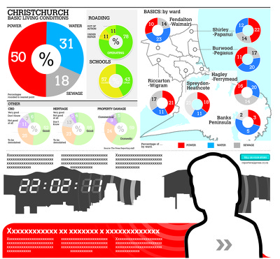
An incomplete infographic showing damage to services.

An infographic showing changes in median rents from September 2011 to September 2012.

A map showing the location of businesses in Sydenham.

A graphic showing the shortfall in Christchurch City Council's insurance cover.

A car covered in toys parked outside Gap Filler's first project at 832 Colombo Street.

An infographic comparing rises in rental prices in Christchurch with the rest of New Zealand.

Photo of damage in Halswell & Tai Tapu, taken by Dan Harrison, 10 September 2010.

The South New Brighton jetty has been closed for 3 or 4 years (fenced off) then the fence was removed and it was "open", but nothing has happened to it since the earthquakes, but it is closed again now, although it looks like a home made sign!

A man representing the South Island stands under an umbrella representing 'hope' to shelter from a bucketload of water representing 'misfortune'. Context - in the last year apart from the usual droughts and floods the South Island has suffered the Pike River Mine disaster on 19 November 2010 in which 29 coal miners were killed, the 7.1 earthquake on 4 September 2010 in which there was a lot of damage but no deaths and now on 22 February 2011 a 6.3 magnitude earthquake which has probably killed more than 200 people (at this point the number is still not known) and caused more severe damage. The reason the apparently lesser magnitude quake caused more destruction is because it was very shallow, was in the middle of the day and struck very close to the centre of the city.
Quantity: 1 digital cartoon(s).

20160104_1602_7D2-20 Porritt Park
Porritt Park was, before the earthquakes, the headquarters of hockey in this region. Two astro-turf fields (the main one was to the left of the building), and corporate offices etc.
The earthquakes buckled all the playing surfaces and damaged the buildings; a couple of smaller ones have been removed.
Hocke...

Christchurch's Cathedral

A photograph of a map used by emergency management personnel to inspect buildings after the 22 February 2011 earthquake. The map is of the block bordered by Barbadoes Street, Worcester Street, Gloucester Street, and Fitzgerald Avenue. Many of the buildings have been highlighted in blue, with some smaller buildings highlighted in orange. Two blocks of buildings have been outlined in dark-blue felt-tip pen. Numbers and messages have been written on the map with biro.

Demolition of the support structure for NZ Breweries smokestack in Christchurch. CERES NZ's nibbler is at work, the pipe stack having been removed yesterday (Saturday). I retuned three hours later to see what progress had been made and it was GONE! See next photo. Damage to complex was from the 22/02/20011 earthquake.
Porritt Park was, before the earthquakes, the headquarters of hockey in this region. Two astro-turf fields (the main one was other side of the building), and corporate offices etc.
The earthquakes buckled all the playing surfaces and damaged the buildings; a couple of smaller ones have been removed.
Hockey shifted the other side of the city t...

Photo of damage in Christchurch CBD, taken by Carolyn Eng, Publications, 7 September 2010 .

Paperback book with removable cover written in Japanese.