
A photograph of the west side of the of the ChristChurch Cathedral, and crowds of people in Cathedral Square. Scaffolding can be seen at the front of the Cathedral and The Chalice is in the distance.

Photograph captioned by BeckerFraserPhotos, "Knox Church, Bealey Avenue". There is a foam heart pegged to the fence reading, "'We can do no great things; only small things with great love' Mother Teresa".

A view down High Street, looking north-west through the cordon fence near the Tuam Street intersection. On the left a line of shipping containers support the facade of a damaged building. Rubble from demolished buildings can be seen in the distance.

A view down High Street, looking north-west through the cordon fence near the Tuam Street intersection. On the left a line of shipping containers support the facade of a damaged building. Rubble from demolished buildings can be seen in the distance.

Dried liquefaction silt in North New Brighton. The photographer comments, "Here you can see the very fine surface layer of liquefaction starting to shrink, crack and then curl up on itself".
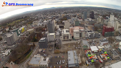
A snapshot from GPS Boomerang's SmartBird flight over the Christchurch red zone on 5 June 2012, looking over Hereford Street with the Re:Start container mall visible in the bottom right. The Cathedral can be seen in the middle right, Oxford Terrace to the left.

A photograph looking south down Colombo Street from the Avon River bridge. In the distance, the Copthorne Hotel and Forsyth Barr building can be seen. A collection of cranes are parked along the street.

A photograph of flooding on a residential street in Christchurch. Large piles of gravel have been placed along the street with cordon fences in front of them. Road cones can be seen in the foreground.

A photograph taken from Oxford Terrace, looking across a cleared site to the corner of Gloucester Street and Colombo Street. ChristChurch Cathedral and the Novotel building can be seen in the distance.

A photograph taken from Oxford Terrace, looking across a cleared site to the corner of Gloucester Street and Colombo Street. ChristChurch Cathedral and the Novotel building can be seen in the distance.

A photograph taken from Oxford Terrace, looking across a cleared site to the corner of Gloucester Street and Colombo Street. ChristChurch Cathedral and the Novotel building can be seen in the distance.

A photograph of a removed roof on the ground on the corner of Tuam Street and Manchester Street. A stack of shipping containers can be seen in the distance, against the remaining facade of the Excelsior Hotel building.

A photograph looking east down Tuam Street. The old Post Office building (now C1 Espresso) can be seen in the distance on the left. On the right is the badly-damaged McKenzie & Willis building.

A photograph of a cleared building site on High Street. Three shipping containers are stacked against the remaining facade of the Excelsior Hotel building on the left. The badly-damaged McKenzie & Lewis building on Tuam Street can be seen in the distance.

View down Victoria Street with the Casino on the right having some construction working being done, and the deconsruction of the Crowne Plaza Hotel at the end of the street. Flags in Canterbury colours, red and black can be seen on the street lights.

A photograph of SPCA Wellington vehicles parked on the intersection of Lichfield and Manchester Streets after the 22 February 2011 earthquake. In the background, the earthquake damage to the Tower Chambers building can be seen.

Sally Roome talking to members of the Sumner community outside the UC QuakeBox container in Sumner. Above, the damaged cliffs can be seen with a house at the edge on a lean.

Members of the public at Gap Filler's "Film in the Gap!" project in Beckenham. Gap Filler has provided old beds and garden swing seats as seating. In the background, the red Southern Espresso Rescue van can be seen.

Emergency personnel searching for people trapped in the collapsed Canterbury Television Building on Madras Street. Smoke can be seen rising from the ruins. On the left is an excavator which has been used to shift the rubble.

Buckled curbing along Jones Street in Kaiapoi. A pile of liquefaction can be seen in the foreground as well as a few plastic pipes. A number of portaloos line the street in the distance as well as road cones.

St John Ambulance personnel standing over a stretcher loaded with medical supplies outside the collapsed Canterbury Television Building on Madras Street. Behind them, emergency personnel can be seen searching the ruins of the building for trapped people.

A photograph of Pretty Things on Colombo Street, with damage to the front wall and fencing around the building. A red sticker can be seen on the front door, indicating that the building is unsafe to enter.

Members of the central and lower North Island Territorial Forces clearing silt from a resident's garden in Christchurch. Sapper Nelson Lambert from Palmerston North can be seen pushing a wheelbarrow.

A photograph of the central city taken from a car park on Gloucester Street. The Rendezvous Hotel, Forsyth Barr building and PricewaterhouseCoopers building can be seen in the distance. An excavator is clearing rubble to the right.

The demolition site of the ANZ Building. A digger sits behind a pile of rubble, and water fills the former basement. The former post office can be seen in the background.

A photograph taken from Oxford Terrace, looking across a cleared site to the corner of Gloucester Street and Colombo Street. ChristChurch Cathedral and the Novotel building can be seen in the distance.

An abandoned residential property at 34 Waygreen Avenue in New Brighton. The front of the section is overgrown with weeds and silt from liquefaction. Cushions lie on the footpath. A blue sticker can be seen on the window.

The sunken footpath around the base of a power pole on Bracken Street in Avonside. Dry silt from liquefaction can be seen mixed in with the gravel around it as a result of the 4 September 2010 earthquake.

An aerial photograph of a residential area in Burwood. At the bottom of the photograph, New Brighton Road can be seen and Queensbury Street is running up the middle.

A view down New Brighton Road where silt from liquefaction still remains on the street curb. A power pole in the foreground is on a noticeable lean and a Port-a-loo can be seen to the right.