
None

A photograph taken near the intersection of Manchester Street, Lichfield Street and High Street. The old Post Office building, now housing C1 Espresso, can be seen in the distance with Ronnie Van Hout's sculpture on the roof. Coloured shipping containers support the remaining front facade of the Excelsior Hotel building.

A photograph taken from the top of the BNZ building. The photograph is captioned by BeckerFraserPhotos, "Finally, the mess outside Coffee Culture on High Street has been cleared and demolition work will complete what the earthquake began. The red containers in the background are Fletchers containers, servicing the Hotel Grand Chancellor deconstruction".

A photograph of a map used by emergency management personnel to inspect buildings after the 22 February 2011 earthquake. The map is of the streets to the north-west of Cathedral Square. An area encompassing parts of St Asaph, Madras, Tuam, High, and Lichfield Streets have been outlined with biro.

A photograph of the Stranges Building on the corner of High Street and Lichfield Street. In the background are the Mexican Café and Honey Pot Café buildings. The outer wall of the top storey of the Stranges Building has collapsed and the rubble has spilled onto the footpath below.

A photograph of members of the Wellington Emergency Management Office Emergency Response Team and the Red Cross working on High and Manchester Streets. On both sides of the street there are piles of rubble from the earthquake-damaged buildings. Several excavators have been parked in a line along the street.

A photograph taken near the intersection of Manchester Street, Lichfield Street and High Street. The old Post Office building, now housing C1 Espresso, can be seen in the distance with Ronnie Van Hout's sculpture on the roof. Coloured shipping containers support the remaining front facade of the Excelsior Hotel building.

Workers placing road cones on a newly re-opened stretch of High Street.

A view down High Street, looking south-east from the Cashel Street intersection.

The backs of damaged buildings on High Street, seen from St Asaph Street.

The backs of damaged buildings on High Street, seen from St Asaph Street.

The backs of damaged buildings on High Street, seen from St Asaph Street.

Diggers demolishing the former Christchurch Girls' High building after it was damaged by the earthquakes.

Diggers demolishing the former Christchurch Girls' High building after it was damaged by the earthquakes.
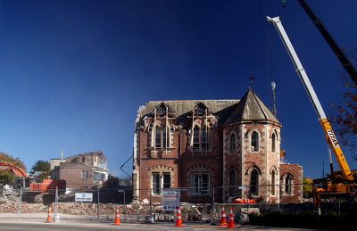
Diggers demolishing the former Christchurch Girls' High building after it was damaged by the earthquakes.

Diggers demolishing the former Christchurch Girls' High building after it was damaged by the earthquakes.

A tram in front of the former Christchurch Girls' High building seen before the earthquakes.

Photograph captioned by BeckerFraserPhotos, "The Manchester, High, and Lichfield Streets intersection".

Photograph captioned by BeckerFraserPhotos, "235-243 High Street and Westpac building".

A photograph of High Street, looking south east from the Colombo Street intersection.

A photograph of High Street, looking south-east towards the Cashel Street intersection.

A photograph of a building facade on High Street supported by shipping containers.

A photograph of high school students working at the Fitzgerald Avenue Community Garden.

A photograph of High Street, looking south-west from the Colombo Street intersection.

A photograph captioned by BeckerFraserPhotos, "A collapsed building on High Street".

A photograph captioned by BeckerFraserPhotos, "A collapsed building on High Street".

A photograph of High Street, looking south east from the Colombo Street intersection.

A photograph of High Street, looking south east from the Colombo Street intersection.

Photograph captioned by Fairfax, "Aerial pictures of earthquake damage in Christchurch. High Street".

A photograph of High Street, looking north west from the Lichfield Street intersection.