
Artificial fabric and plastic orange gerbera with stem.

Slightly flared plain white glazed bowl. Bowl is dirty.

Tuam Street opposite Alice's

Carparking Structure Tuam Street

Hotel Grand Chancellor, Christchurch.

Plywood windows and doors, Shirley Road.
File reference: CCL-2012-05-10-Around-Shirley-May-2012 DSC_02861.JPG
From the collection of Christchurch City Libraries.

Text reads 'AFTERSHOCK$$$$$$$$$$$ $2 billion $4 billion'. Refers to the estimated costs resulting from the Canterbury earthquake of 4th September 2010 - The '2' is crossed out and the 'Treasury' pen writes '4' in its place.
Quantity: 1 digital cartoon(s).

One landscape colour digital photograph taken on 19 November 2011 showing part of the north side of London Street. The properties visible in the photograph are (from left to right) Tommy Changs Café, Canterbury Street, site of theatre erected for the Loons Circus Theatre Company production of Macbeth (being dismantled), Lyttel Arthouse (closed),...

One landscape colour digital photograph taken on 19 November 2011 showing buildings on London Street. Visible in the photograph (left to right) are Bells Pharmacy - relocated into a converted house with law firm MacTodd on the upper floor, Portico (gift shop), Tommy Changs Cafe, and the edge of the Lyttelton Petanque Club Gap Filler initiative. ...

One landscape colour digital photograph taken on 19 November 2011 showing the site of the Albion Hotel/ Ground Delicatessen. After the demolition of the building the site was used for a Gap Filler initiative called the Lyttelton Petanque Club. The photograph shows the temporary furniture, landscaping and public Petanque court. The site formerl...

One landscape colour digital photograph taken on 19 November 2011 showing part of the north side of London Street. The properties visible from left to right are: Himalaya Design (obscured), Coffee Culture (downstairs), J Voyce and Co Ships Providore (upstairs), empty shop, and Lyttel Piko Organic and Wholefoods The Lyttelton streetscape has cha...

One landscape colour digital photograph taken on 19 November 2011 showing part of the north side of London Street. The properties visible from left to right are: part of Lyttel Piko Organic and Wholefoods, Satchmo Café Pizzabar, Milly May and Snoclothes New Zealand. The empty section was formerly occupied by No. 6 Cafe. The Lyttelton streetsc...

One landscape colour digital photograph taken on 26 May 2013 showing the Godley Head Lighthouse and cliffs. Taken from the entrance to Lyttelton Harbour looking north. The Godley Head Lighthouse (K4286) was discontinued on 6 July 2012. Volcanic banding is visible in the face of the cliffs. There were several major rock falls along the coastal ...

One landscape colour digital photograph taken on 19 November 2011 looking east from Norwich Quay from approximately the base of Canterbury Street. Visible in the photograph are the partially deconstructed former Lyttelton Harbour Board Offices, the Holcim Cement Silos, the Oxford Street Railway Overbridge, Lyttelton Port of Christchurch's storag...

One portrait colour digital photograph taken on 19 November 2011 showing Shadbolt House prior to its demolition. Architect Lyttelton's tallest building before its demolition was built in 1961 as the offices of the Lyttelton Harbour Board. At the time it was demolished the building was known as Shadbolt House and was owned by Independent Fisherie...

One landscape colour digital photograph taken on 26 May 2013 of London Street, Lyttelton. The photograph was taken from St Davids Street looking west. The roofs of the portable buildings forming the temporary Lyttelton Police station are visible in the foreground. The Lyttelton Port Company offices and Tunnel Portal are prominent in the midgrou...

One landscape colour digital photograph taken on 26 May 2013 on the corner of Norwich Quay and Canterbury Street, Lyttelton. The photograph shows the sites of the Royal Hotel, Shadbolt House, and the Lyttelton Hotel along Norwich Quay. The Wunderbar and the repair and strengthening work underway on the Lyttelton Working Mens Club/The Loons are v...
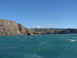
One landscape colour digital photograph taken on 26 May 2013 off Godley Head looking north to Boulder Bay and Taylors Mistake. Rock which fell from the cliffs is heaped at the waters edge. Volcanic banding is visible in the face of the cliffs. There were several major rock falls along the coastal cliffs near Christchurch and Lyttelton Harbour....

One landscape colour digital photograph taken on 26 May 2013 off Godley Head looking north towards Sumner Head. There were several major rock falls along the coastal cliffs near Christchurch and Lyttelton Harbour. In and around the suburb of Sumner some of these falls necessitated the abandonment of houses in areas where cliffs had given way or...

One landscape colour digital photograph taken on 19 April 2011 showing the demolition of the Empire Hotel on London Street. The photograph shows the façade of the hotel supported by the framework installed to brace the building after the 4 September 2010 earthquake. A crane is being used to enable the east wall to be demolished by hand to avoid...

One landscape colour digital photograph taken on 25 September 2011 showing the remaining portion of the former Convent of Our Lady of Mercy. St Mary's School, run by the Sisters of Mercy, was also housed in this building. At the time of the 4 September 2010 earthquake the building was a private residence. The picture shows the perimeter wall, t...

One landscape colour digital photograph taken on 7 March 2011 showing Her Majesty's New Zealand Ship (HMNZS) Canterbury departing Lyttelton following the completion of her support role in Canterbury following the 22 February 2011 Earthquake. The photograph shows HMNZS Canterbury passing through the Moles out of the Inner Harbour and turning to ...

UC Senior Management Team at the Emergency House after the September earthquakes.

Students in the Student Volunteer Army cleaning up silt after the earthquake.

A toppled filing baniet in the Engineering library after the September earthquake.

Students in the Student Volunteer Army cleaning up silt after the earthquake.

Students in the Student Volunteer Army cleaning up silt after the earthquake.

Students in the Student Volunteer Army cleaning up silt after the earthquake.

Students in the Student Volunteer Army cleaning up silt after the earthquake.

Post-earthquake progressive re-start, outside the entrance to the NZi3.