
A photograph of earthquake-damaged buildings along Hereford Street near the intersection with Manchester Street. Wire fencing has been placed along the street as a cordon.

A photograph looking west down Cashel Street from the intersection with Madras Street. In the distance, wire fencing has been placed across the street as a cordon.

A photograph looking south down Colombo Street from the intersection of Hereford Street. A section of road on the right has been cut out and is surrounded by road cones.

A photograph looking south down Colombo Street from the intersection of Hereford Street. Pieces of pipe are lying in the gutter and pavement bricks have been upturned.

A photograph looking east along Tuam Street towards the intersection with Manchester Street. Collapsed buildings and a stack of shipping containers can be seen in the distance.

A view through the cordon at the intersection of Oxford Terrace and Hereford Street. The building rubble in the background used to be the Mythai Thai Restaurant & Monkey Bar on Hereford Street.

The intersection of Kilmore Street and Fitzgerald Ave. Damaged buildings in the background have been cordoned off with fencing and road cones. Plastic road barriers have been placed to divert the traffic.

A photograph of a humorous sign reading, "Warning! No pot holes next 400 m". The photograph captioned by Paul Corliss, "Just before intersection of Kilmore St with Fitzgerald Avenue".

A photograph of a humorous sign reading, "Warning! No pot holes next 400 m". The photograph captioned by Paul Corliss, "Just before intersection of Kilmore St with Fitzgerald Avenue".

A view of the intersection of Cambridge Terrace and Worcester Boulevard. From the left are the Police station, Christchurch City Council's Civic Offices, the HSBC Tower and the Harley Building on the right.

Looking inside the CBD cordon at the intersection of Tuam and Manchester Streets. The The Odeon Theatre and the Pink Pussy Cat Building formerly Lawrie & Wilson Auctioneers can seen in the background.

A photograph of a humorous sign reading, "Warning! No pot holes next 400 m". The photograph captioned by Paul Corliss, "Just before intersection of Kilmore St with Fitzgerald Avenue".

A photograph of a humorous sign reading, "Warning! No pot holes next 400 m". The photograph captioned by Paul Corliss, "Just before intersection of Kilmore St with Fitzgerald Avenue".

The intersection on the corner of Colombo and Bealey Avenue. In the background, the demolition site where the Bealey Pharmacy was. A damaged car sits on top of the pile of building rubble.

The cordon checkpoint at the intersection of Colombo and Gloucester Streets. In the background, people stand in a section of walkway opened up to allow the public a view of Cathedral Square.

A photograph of a humorous sign reading, "Warning! No pot holes next 400 m". The photograph captioned by Paul Corliss, "Just before intersection of Kilmore St with Fitzgerald Avenue".

The intersection of Kilmore Street and Fitzgerald Ave. Damaged buildings in the background have been cordoned off with fencing and road cones. Plastic road barriers have been placed to divert the traffic.
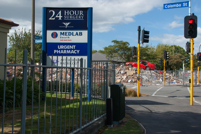
The intersection on the corner of Colombo and Bealey Avenue. In the background, the demolition site where the Bealey Pharmacy was. A damaged car sits on top of the pile of building rubble.

Photograph captioned by BeckerFraserPhotos, "A view looking from the Edmonds Band Rotunda across the River Avon to the intersection of Manchester Street and Oxford Terrace".

An aerial photograph of the intersection of High, Lichfield and Manchester Streets. The site of the Strange's building is in the bottom-left quadrant of the photo.

A photograph of the intersection of Durham and Kilmore Streets, with the Copthorne Hotel on the left. Kilmore Street has been cordoned off with cones and tape.

A photograph of Hereford Street taken from the intersection with Oxford Terrace. The street has been blocked off on one side with wire fencing and road cones.

A photograph looking east down Wilmer Street from the intersection with Montreal Street. Emergency tape and road cones have been placed across the road as a cordon.

A photograph looking east down Hereford Street from the intersection with Durham Street. In the distance, members of the New Zealand Army are guarding a cordon fence.

A photograph of emergency management personnel crossing the intersection between Colombo and Hereford Streets. Paving stones have lifted from the corner of the streets in the background.

A photograph looking north down Colombo Street, from the intersection of Armagh Street. In the distance, rubble from the partially-collapsed Winnie Bagoes building can be seen on the road.

A photograph looking south down Colombo Street from the intersection of Armagh Street. The road has been cordoned off and an excavator is demolishing a building on the right.

A photograph looking east down Hereford Street from the intersection with Manchester Street. In the distance, an excavator can be seen filling a truck with the rubble from a demolished building.
A photograph of the Treehouse Bar and Manchester Courts taken from the intersection of Manchester and Cashel Streets. Wire fencing has been placed across the street as a cordon.

A photograph looking west down Gloucester Street, taken from the Cambridge Terrace intersection. Wire fencing can be seen along both sides of the footpath, keeping people away from the buildings.