
A list of newly released casualities of the 22 February 2011 earthquake.

A map showing the possible location of a fault line below Christchurch.

A map showing the location of an emergency stopbank on Avonside Drive.

A list of newly released casualities of the 22 February 2011 earthquake.

Text at top reads 'Some Christchurch suburbs to move?... The cartoon shows three complete suburbs that have been dug up and are now being flown by helicopters attached to tall towers to their new spots on the Australian Gold Coast. Someone in one of the houses on the move yells 'Woohoo! Yeehaa! Well... As NZ and Ozzie are such great mates... Gold Coast here we come!' Context - In some cases where whole communities have to move because the earthquakes have made it impossible for them to remain in their present locations, many in the community have elected to try to move and relocate together in order to retain their old neighbours and community spirit.
Quantity: 1 digital cartoon(s).

Depicts huge elderly woman with 'CERA' on her dress scolding smaller adult dressed as schoolboy near bustop with sign 'CBD red zone tours' Text reads 'And don't talk to strangers and don't cross the road and remember to eat your lunch..' Context: After the 22 Feburary 2011 earthquake in Christchurch, the central business district (CBD) was marked as a red zone. Red zone areas were deemed unsuitable for habitation due to significant damage and at high risk of further damage from low levels of earth shaking. CERA (Christchurch Earthquake Recovery Authority) ran public bus tours of the Christchurch CBD from November to December 2011. For safety reasons the public was not allowed off the buses as it was a dangerous and active demolition site.
Quantity: 1 digital cartoon(s).

A map showing the locations of proposed developments in the central city.

The layout for an interactive web graphic showing the results of a survey on insurance claims.

A map which was used to illustrate an Ask the Expert feature, showing the locations of aftershocks and fault lines.

An infographic showing the fault ruptures which caused the 4 September 2010 and 22 February 2011 earthquakes.

Graphs showing the result of an opinion poll on reactions to the Central City Recovery Plan.

A graphic showing the magnitude 8.2 and 8.6 Indonesian earthquakes, which were recorded on the McQueens Valley seismograph.

A chart showing the results of a poll, comparing responses from Canterbury to those from the rest of New Zealand.

A graphic for an opinion piece on the two minutes' silence observed one week after the 22 February 2011 earthquake.

A chart showing the results of a poll, comparing responses from Canterbury to those from the rest of New Zealand.

A map showing the location of a study looking for historic earthquakes on the Alpine Fault.

A page banner promoting an article about the proposed development of the Hagley Park cricket oval.

A chart showing the results of a poll, comparing responses from Canterbury to those from the rest of New Zealand.

A map showing the location of major projects proposed in the Christchurch Central Development Unit's blueprint.

Shows a hand lifting a house up from the ground, as the earth shakes and rumbles around it. A voice in the earth says, 'I'm still here'. Refers to ongoing earthquakes and aftershocks following the devastating 2010 and 2011 earthquakes in Canterbury.
Quantity: 1 digital cartoon(s).

Shows various sized boats for the 'tsunami-conscious' as show homes in Christchurch. Context: There is anxiety about the potential for a local source tsunami but the Christchurch City Council says on its website that there will be no time to issue an official warning for a local source tsunami.
Quantity: 1 digital cartoon(s).

A graphic comparing spending in the Boxing Day and 'Boxing Day replay' sales.

A map showing the airport noise contour relative to residential developments in Kaiapoi.

A map showing the airport noise contour relative to residential developments in Kaiapoi.
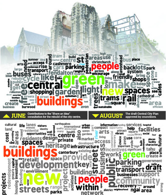
Word clouds comparing the draft Central City Plan to Share an Idea contributions.

An uncompleted page layout with a map showing the locations of damaged buildings.

A page banner promoting articles about the Christchurch rebuild.

An infographic showing retail floor size limits in the draft Central City Plan.

A large sign just outside Christchurch's Red Zone reads 'Christchurch RED ZONE - security staff and celebrities only'. A security guard phones through to Check Point One, saying 'Base to check point one - no shop keepers allowed but the queen, Fidel Castro, Tina Turner and Elvis are coming in'. These four people have formed a queue and are allowed to enter the Red Zone. Context - It is now three months past the earthquake of 19 February and shopkeepers and owners of small businesses are becoming very frustrated by the still limited access to the Red Zone business area.
Colour and black and white versions available
Quantity: 2 digital cartoon(s).

A map showing the proposed location of the Tait Communications business and technology campus.